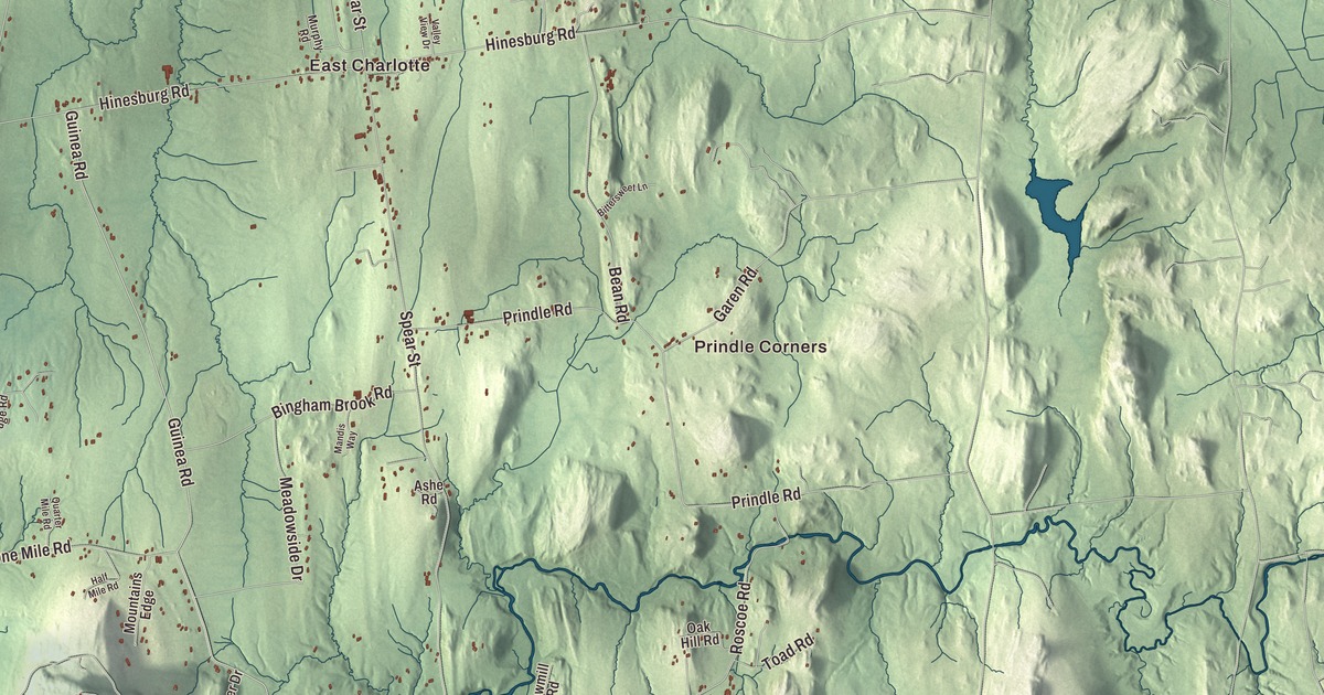
Say it the local way, with the weight on “lotte,” and you’re already talking like someone from Charlotte. This map prints the town from Lake Champlain to Lewis Creek, with East Charlotte, West Charlotte, Prindle Corners and Cedar Beach, and Ethan Allen Highway, Greenbush Road, Spear Street, Mount Philo Road, Lake Road and Town Line Road.
Charlotte is a town in the southwestern corner of Chittenden County, Vermont.
KNOWOL made this map in 2026 from public survey data and gave it the feel of an old county atlas. Shaded relief from United States Geological Survey elevation data brings up the hills, and the roads and the town line come from the Census Bureau. Charlotte covers 50.3 square miles, and 9.1 of them are water: to the west, the town runs out to the New York line in the middle of the lake. It had 3,912 people at the 2020 census. Click here to purchase a print of this map for your wall.
Named for a queen
Charlotte dates to 1762. New Hampshire granted it on June 24 of that year, and the town organized in 1787. It was named for Queen Charlotte, but unlike Charlotte, North Carolina, or Charlottesville, Virginia, the Vermont town puts the accent on the second syllable. Shelburne lies to the north, Hinesburg to the east, and Monkton and Ferrisburgh in Addison County to the south.
The town has two old villages. East Charlotte is in the eastern part of town. West Charlotte, known around town as “the West Village,” sits on the west side of U.S. Route 7, and it’s also called the Four Corners Historic District. From West Charlotte a short state road, Vermont Route F-5, runs down to the ferry dock on the lake.
Vermont’s first state park
Mount Philo rises in Charlotte with views west over Lake Champlain to the Adirondacks. From the late 1800s until 1924 it was a favorite outing for guests of the Mt. Philo Inn. That year the inn’s owner, Francis Humphreys of Brookline, Massachusetts, gave the land to the State of Vermont for recreation, and it became Vermont’s first state park. Mount Philo State Park now covers 237 acres, with hiking trails from the base to the summit, and it’s a good place to watch hawks and other raptors pass on migration.
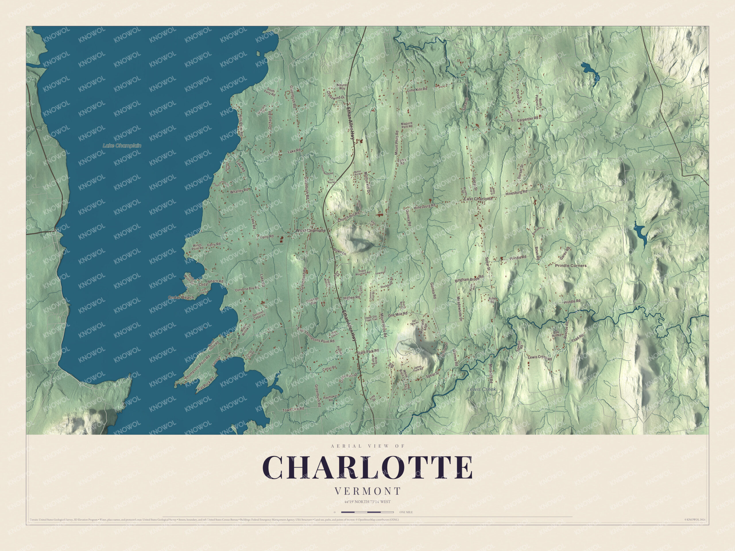
Click to explore a larger preview. The digital watermark does not appear on printed maps.
Names on this map
These names are printed on this map.
Places: Prindle Corners, Cedar Beach, East Charlotte, Lake Champlain, Lewis Creek and West Charlotte.
Streets and roads: Ethan Allen Highway, Greenbush Road, Town Line Road, Spear Street, Mount Philo Road, Lake Road, Hinesburg Road, Guinea Road, Dorset Street, Ferry Road, Thompsons Point Road, Prindle Road.
More street names, A to Z
Ashe Road, Bean Road, Big Oak Lane, Bingham Brook Road, Bittersweet Lane, Black Willow Lane, Bown Lane, Cannon Point Road, Carpenter Road, Cattail Road, Cedar Beach Road, Church Hill Road, Claflin Farm Road, Common Way, Converse Bay Road, Crosswind Drive, Dolliver Drive, East Thompsons Point Road, Elcy Lane, Elfin Lane, Fields Farm Road, Flat Rock Road, Fox Run Road, Garen Road, Half Mile Road, Haymaker Road, Higbee Road, Hills Point Road, Holmes Road, Inn Road, James Farm Road, Lanes Lane, Lewis Creek Road, Lime Kiln Road, Line Drive, Long View Trail, Lucy's Lane, Maguire Pent Road, Mandis Way, Meadowside Drive, Monkton Road, Mountains Edge, Murphy Road, Museum Road, Mutton Hill Drive, Mutton Hill Road, Natures Way, North Pasture Lane, North Shore Road, Oak Hill Road, One Mile Road, Orchard Road, Palmer Lane, Patton Woods Road, Pease Mountain Road, Popple Dungeon Road, Quarter Mile Road, Ridge Road, Riverview Drive, Roscoe Road, Sawmill Road, Sentinel Cedar Lane, South Forty Road, State Park Road, Stockbridge Road, Stone Wall Lane, Tamarack Road, Thorpe Cove Road, Toad Road, Tom's Road, Turtle Moon Road, Upper Old Town Trail, Valley View Drive, Whalley Road, White Birch Lane, Windy Ridge Road, Wings Point Road.
See it on a wall
The Charlotte map as a framed print. Swipe for more.


The ferry and the covered bridge
From Charlotte you can cross Lake Champlain by boat. The Lake Champlain Transportation Company runs an hourly ferry between Charlotte and Essex, New York, and in most recent years it has run all year, stopping only for a few days when the lake is rough or icy. Inland, the Seguin Covered Bridge carries Roscoe Road over Lewis Creek in eastern Charlotte. It was built around 1850 by a builder nobody recorded, and it’s one of three covered bridges that survive in town and one of nine in Vermont built with the Burr arch design. The town’s sign spells it “Seguin” for a family that owned the land around it.
Charlotte people
Cyrus Pringle was born in Charlotte in 1838. He started as a plant breeder on his mother’s farm, bred the ‘Snowflake’ potato, and went on to spend 35 years cataloguing the plants of North America, including 39 collecting trips to Mexico for the Gray Herbarium. He’s buried in Morningside Cemetery in East Charlotte. The landscape architect Dan Kiley, who designed more than a thousand projects in the modern style, among them Gateway Arch National Park, later moved to Charlotte. Sir Wilfred Grenfell, the medical missionary who opened hospitals along the coast of Labrador, died at Kinloch House in Charlotte in 1940. The town has kept its own newspaper, the Charlotte News, going since 1958 as an independent nonprofit.
To find your own corner of town, start at the water. Lake Champlain fills the whole western edge of the sheet, with Cedar Beach and Lake Road near the shore. Ethan Allen Highway, Spear Street, Greenbush Road, Mount Philo Road and Town Line Road are printed on the map farther inland, and so are Prindle Corners, West Charlotte and East Charlotte, with Lewis Creek winding through the east side of town.
Hang this map of Charlotte in an office, library or den, or use it to teach children the geography and history of a lake town. It’s made for everyone who calls Charlotte home and shows the town as it looks today, from the ferry dock to East Charlotte. KNOWOL created it in 2026, and it’s printed on museum quality archival paper. Zoom in on the preview above to explore the details, then click here to get your copy of the Charlotte, Vermont map.

Sources