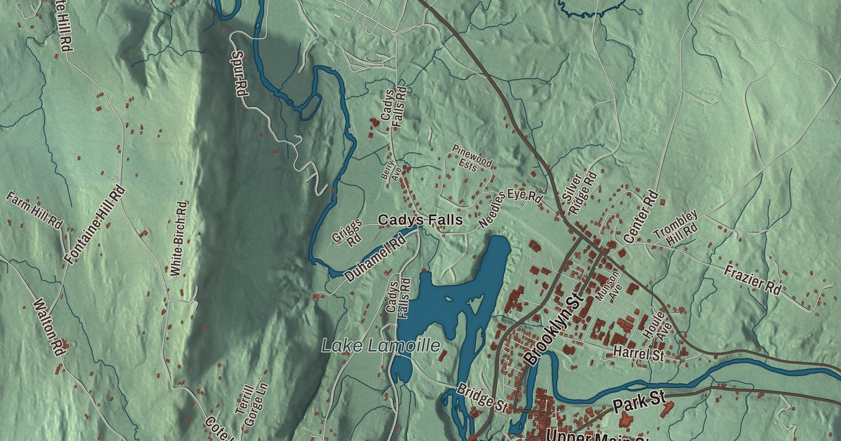
Morristown stretches south from the Lamoille River into a broad valley east of the Green Mountains’ main range, with the village of Morrisville in its northern part. This map prints Laporte Road, Upper Main Street, Elmore Road, Park Street, Brooklyn Street and Walton Road, with Cadys Falls, Morrisville and Lake Lamoille.
Morristown is a town in Lamoille County, Vermont.
KNOWOL made this map in 2026 from public survey data and gave it the look of an old county atlas, shading the hills from United States Geological Survey elevation data and drawing the roads and town line from the Census Bureau. The town covers 51.7 square miles, and 5,434 people lived here at the 2020 census, the most of any town in Lamoille County. Click here to purchase a print of this map for your wall.
A town that changed counties
Vermont granted Morristown on November 6, 1780, and chartered it on August 24, 1781. The town organized in March 1796 as part of Orleans County, and it stayed there until Lamoille County was organized in 1836. Elisha Boardman was its first representative in the legislature, in 1804, and Samuel Cook and Luther Bingham each held the seat for several terms in the decades that followed. Its central village, Morrisville, serves as the county’s main commercial center.
The Lamoille River flows through the northern part of town, and Ryder Brook and other streams join it from the broad valley to the south. Morrisville sits on the river, east of Lake Lamoille, a small reservoir. Several state highways come together here. Route 100 runs northwest 3 miles to Hyde Park, the county’s shire town, and south 8 miles to Stowe, and Morristown is the most populous town on the whole length of Route 100. Route 12 heads southeast 26 miles to Montpelier, and Route 15 crosses the town north of the village on its way between Jeffersonville and Hardwick. Legend says early French settlers called the river La Mouette, “the seagull,” and that a mapmaker who forgot to cross his t’s turned it into La Moulle, which became Lamoille.
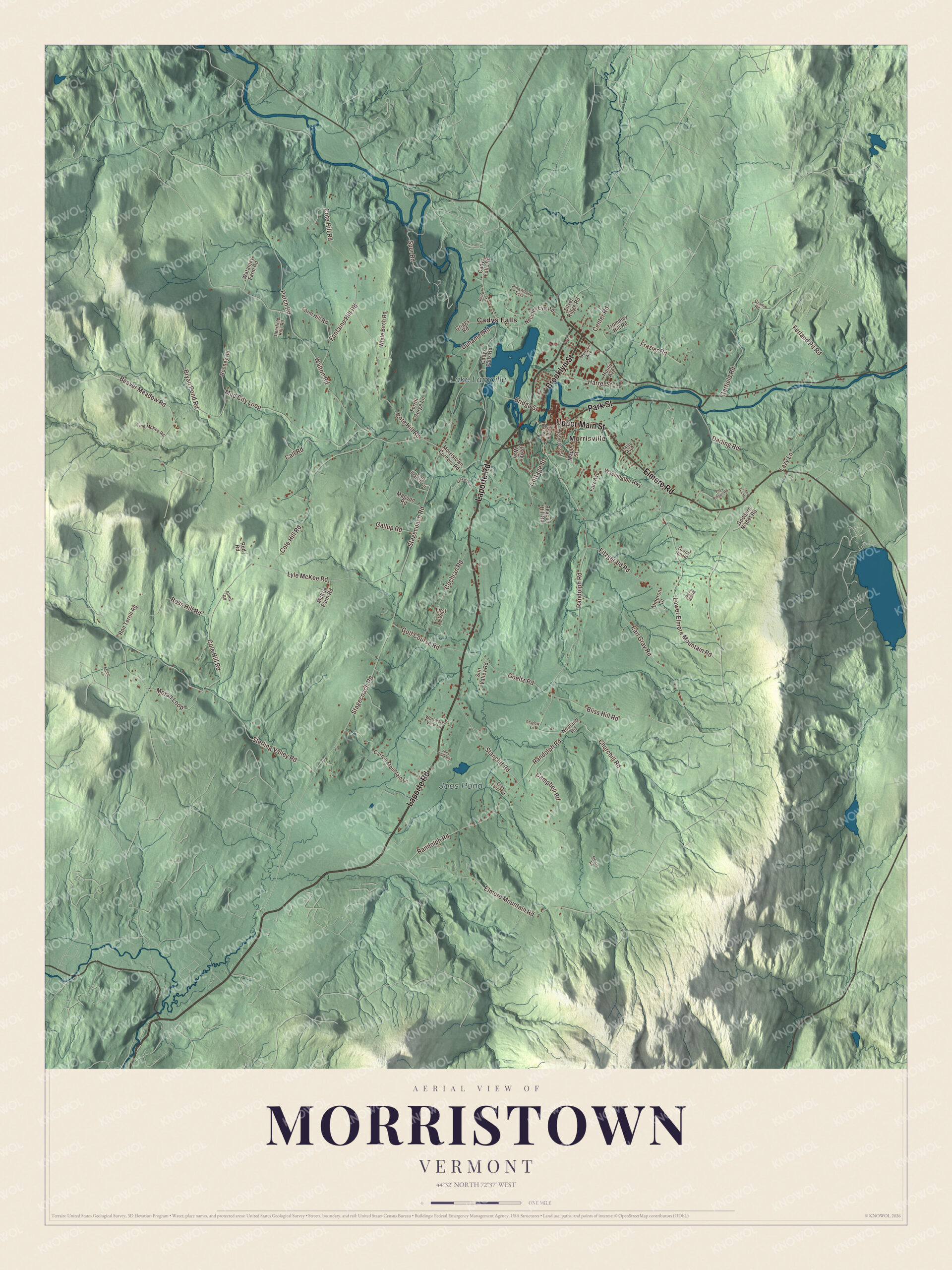
Click to explore a larger preview. The digital watermark does not appear on printed maps.
Names on this map
These names are printed on this map.
Places: Lake Lamoille, Joes Pond, Cadys Falls and Morrisville.
Streets and roads: Laporte Road, Upper Main Street, Elmore Road, Park Street, Brooklyn Street, Walton Road, Cote Hill Road, Randolph Road, Stagecoach Road, Mud City Loop, Cole Hill Road, Sterling Valley Road.
More street names, A to Z
Allen Road, Almeron Drive, Arctic Lane, Beacon Hill Road, Beaver Meadow Road, Berry Avenue, Bliss Hill Road, Bridge Street, Bryan Pond Road, Cadys Falls Road, Call Road, Campbell Road, Carroll Mountain Lane, Center Road, Churchill Road, Cochran Road, Congress Street, Cottage Street, Cram Road, Darling Road, Deerfield Hills Road, Duhamel Road, Earl Gray Road, East High Street, Elmore Mountain Road, Farm Hill Road, Farr Avenue, Ferland Pit Road, First Street, Fitzgerald Road, Fontaine Hill Road, Frazier Road, Gallup Road, Garfield Road, Goddard Nisbet Road, Goeltz Road, Golf Course Road, Gray Farm Road, Griggs Road, Harrel Street, Houle Avenue, Jersey Way, Joes Pond Road, Lazy Lane, Long Branch Circle, Lower Elmore Mountain Road, Lyle McKee Road, Magoon Road, Maple Street, McKee Farm Road, Moran Loop, Morristown Corners Road, Mowry Road, Munson Avenue, Needles Eye Road, Neuland Road, Paine Avenue, Patch Road, Pinewood Ests, Pvt Ridges Road, Red Road, Ron Terrill Road, Rooney Road, Ross Hill Road, Sand Hill Heights, Shadow Lane, Silver Ridge Road, Spring Hill Road, Spur Road, Stancliff Road, Stickell Road, Sun Valley Road, Terrill Gorge Lane, Tine McKee Road, Towne Hill Road, Trombley Hill Road, Washington Highway, Watanjay Farm Road, White Birch Road, Worcester View Lane.
See it on a wall
The Morristown map as a framed print. Swipe for more.


The Red Bridge and the Noyes House
Out in Sterling Valley, in the southwest of town, the Red Covered Bridge carries Cole Hill Road over Sterling Brook. It was built in 1896 and is the only 19th-century covered bridge left in Morristown, and one of the last built in Vermont in that century. It’s a queen post truss, 64 feet long, sided in red-painted boards, and its unusually thick bottom chords are built up from twelve layers of planking. Steel beams were set under the deck in 1971 to carry the traffic. Overlooking the Lamoille, the Noyes House Museum is a house built in 1797, enlarged with a brick Federal addition in 1810, with an English barn from the 1820s. Its exhibits show 19th-century life in Morristown through furniture, clothing, tools, pottery and photographs, and its collection includes an 18th-century Native American dugout canoe.
Two speakers and a treasury secretary
H. Henry Powers was born in Morristown in 1835 and graduated from People’s Academy. He was elected Speaker of the Vermont House in 1874, resigned to join the Vermont Supreme Court, where he served until 1890, and then represented Vermont in Congress from 1891 to 1901 before going back to his law practice in Morristown. Leslie M. Shaw, born here in 1848, went west to Iowa, became its 17th governor, and served as Secretary of the Treasury under Theodore Roosevelt from 1902 to 1907. More recently, Shap Smith of Morristown, who represented the town in the Vermont House, served as the 92nd Speaker of the House from 2009 to 2017.
On the map, start at Cadys Falls and Morrisville, then follow Laporte Road, Upper Main Street, Elmore Road, Park Street, Brooklyn Street and Walton Road. Lake Lamoille and Joes Pond are printed. Morristown dates to 1781.
This map of Morristown is made for everyone who calls Morristown home, and it shows the town as it looks today, from the Lamoille River to Cadys Falls. Hang it in an office, library or den, or use it to teach children the geography and history of their town. It’s printed on museum quality archival paper. Zoom in on the preview above to explore the details, then click here to get your copy of the Morristown, Vermont map.

Sources
- Morristown, Vermont, Wikipedia
- Town histories and representatives, M towns, Vermont Legislature
- Vermont Route 100, Wikipedia
- Lamoille River, Wikipedia
- Red Covered Bridge (Morristown, Vermont), Wikipedia
- Noyes House Museum, Wikipedia
- H. Henry Powers, Wikipedia
- Leslie M. Shaw, Wikipedia
- Shap Smith, Wikipedia