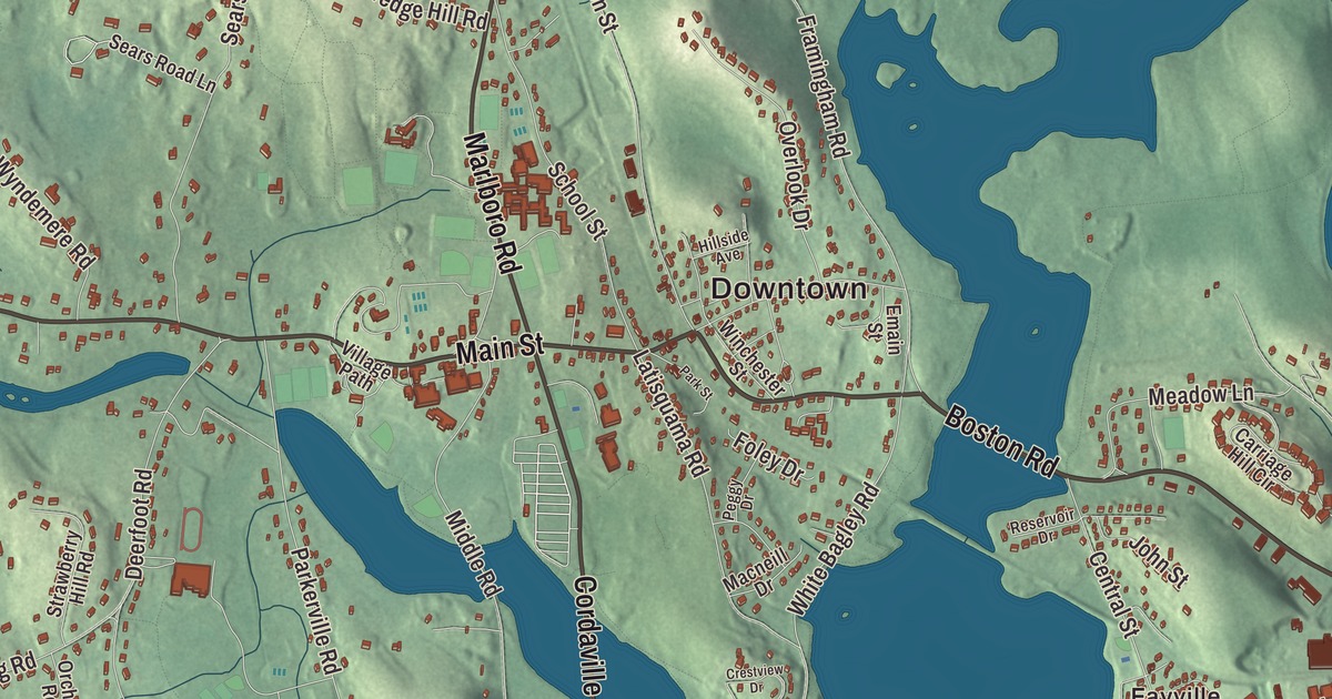
Southborough’s villages are all here, Southville, Cordaville and Fayville, along with Main Street through the center, Cordaville Road and Marlboro Road running out from it, and the waters of Sudbury Reservoir and Crystal Pond. Click here to purchase a print of this map for your wall.
Southborough is in Worcester County.
KNOWOL made this map in 2026 from public survey data, drawn in the spirit of an old county atlas. The hills come from United States Geological Survey elevation data, and the roads and the town line come from the Census Bureau. Southborough covers 15.7 square miles, and 1.5 square miles of it are water. About a tenth of the town lies under Sudbury Reservoir, and open space made up about 35 percent of its land in 2021. Many signs and maps shorten the name to Southboro. The town had 10,450 people at the 2020 census.
The south borough
The Town of Southborough’s recorded history, in the Secretary of the Commonwealth’s list, dates European settlement to 1660, and Southborough was incorporated as a town in 1727. That July it split off as the “south borough” of Marlborough, ten years after Westborough had done the same. The meeting point of Main Street with Marlboro Road and Cordaville Road has been the center of town life ever since, and the town common, the old burying ground and an eighteenth century stone-walled animal pound still survive near it. Main Street was part of the stagecoach road between Boston and Worcester. Southborough farmed at first, then mills on its small rivers turned out plaster, straw bonnets, boots and shoes by the end of the 1800s.
In the 1890s the Sudbury Dam, also called the Fayville Dam for the nearby village, was built to hold back the Stony Brook branch of the Sudbury River for Boston’s growing water supply. Water began filling the reservoir on February 8, 1897. Construction meant moving about 4.5 million cubic yards of soil and boulders, and a cluster of nineteenth century farm buildings was moved out of the way. Manufacturing in town vanished as a result, and Southborough didn’t grow much again until the high-tech boom of the 1970s. No part of Sudbury Reservoir lies in the town of Sudbury; most of it’s in Southborough and Marlborough. It’s now a backup supply, and its watershed is open for hiking, picnicking and shoreline fishing.
The Burnetts and their schools
Joseph Burnett, born in Southborough in 1820, made a fortune as a chemist and manufacturer, and his products included America’s first commercially viable vanilla extract. In 1865 he founded St. Mark’s School, one of the first New England schools built on the British public school model, and it opened with twelve students. A year later his first cousins Eliza Burnett Fay and Harriet Burnett started Fay School in a former parsonage across from St. Mark’s, with seven students. It’s the oldest junior boarding school in the nation. Burnett also paid for the town’s Episcopal church, town hall and library. Parts of the 2023 film The Holdovers were shot in the St. Mark’s dining hall, headmaster’s office and basketball court.
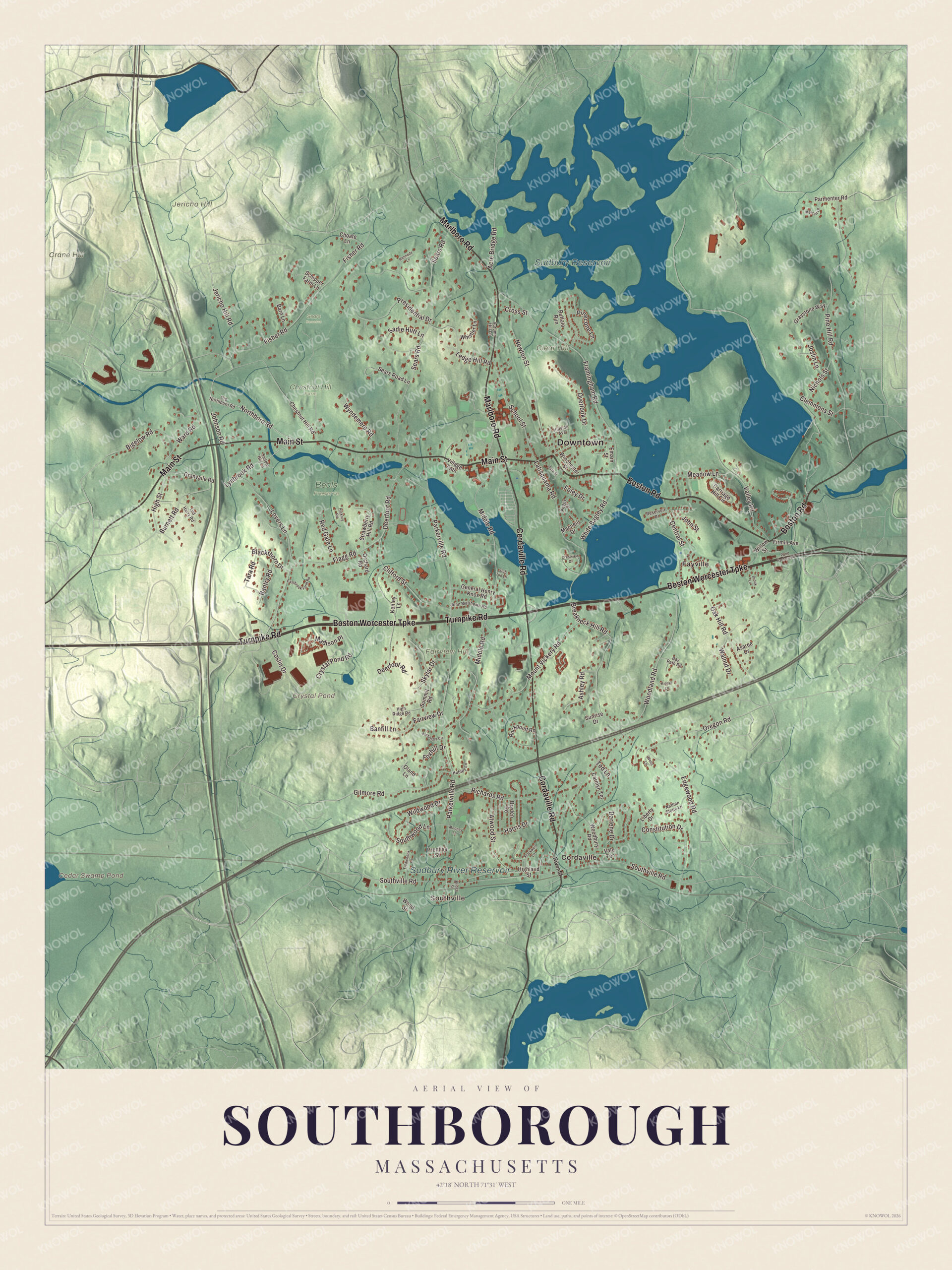
Click to explore a larger preview. The digital watermark does not appear on printed maps.
Names on this map
These names are printed on this map.
Places: Downtown, Southville, Cordaville, Fayville, Clear Hill, Crane Hill, Fairview Hill, Jericho Hill, Cedar Swamp Pond, Crystal Pond, Sudbury Reservoir, Sudbury River Reservoir, Beals Preserve, Chestnut Hill Farm and Sears Reserve.
Streets and roads: Boston Road, Main Street, Boston Worcester Turnpike, Turnpike Road, Cordaville Road, Marlboro Road, Northboro Road, Lynbrook Road, Jericho Hill Road, Madison Place, Parkerville Road, Southville Road.
More street names, A to Z
Acre Bridge Road, Alexandra Circle, Asaree Drive, Ashley Road, Atwood Street, Autumn Hill Lane, Banfill Lane, Bantry Road, Barn Lane, Bay Path Road, Bigelow Road, Blackthorn Drive, Breakneck Hill Road, Bridge Street, Brook Lane, Bryden Road, Buffalo Run, Burnett Road, Carolyn Terrace, Carriage Hill Circle, Central Street, Chestnut Hill Road, Choate Lane, Clemmons Street, Clifford Street, Constitution Drive, Coslin Drive, Crestview Drive, Cross Street, Crystal Pond Road, Darlene Drive, Deerfoot Road, Eastbrook Farm Road, Edgewood Road, Emain Street, Fairview Drive, Fiddleneck Lane, Firmin Avenue, Fisher Road, Flagg Road, Foley Drive, Foxhill Drive, Framingham Road, General Henry Knox Road, Gilmore Road, Granvaile Road, Graystone Way, Harris Drive, Hickory Road, Highland Street, High Ridge Road, High Street, Hillside Avenue, Hubley Lane, John Matthews Road, Johnson Road, John Street, Joslin Lane, Kenley Lane, Kennedy Lane, Kidder Lane, Latisquama Road, Ledge Hill Road, Liberty Drive, Lovers Lane, Macneill Drive, Meadow Lane, Metcalf Lane, Middle Road, Mooney Lane, Mount Vickery Road, Nathan Stone Lane, Newton Street, Nichols Street, Oak Hill Road, Oland Lane, Old Harry Road, Old Northboro Road, Orchard Road, Oregon Road, Overlook Drive, Park Street, Parmenter Road, Peggy Drive, Pinecone Lane, Pine Hill Road, Pond Factory Road, Prentiss Street, Presidential Drive, Red Gate Lane, Reservoir Drive, Richards Road, River Street, Rockpoint Road, Saddle Hill Lane, Sadie Hutt Lane, Schipper Farm Lane, School Street, Sears Road, Sears Road Lane, Skylar Drive, Southwood Lane, Stockwell Lane, Strawberry Hill Road, Stub Toe Lane, Summit Road, Sunrise Drive, Tara Road, Ted Lane, Vale Terrace, Valley Road, Village Path, Walnut Drive, Ward Road, Wells Lane, Whistler Lane, White Bagley Road, Wildwood Drive, Willow Street, Winchester Street, Woodbury Road, Woodland Road, Wood Street, Wyndemere Road.
See it on a wall
The Southborough map as a framed print. Swipe for more.


Around the map
Start with Southville. Follow Boston Road, Main Street, the Boston Worcester Turnpike, Turnpike Road, Cordaville Road and Marlboro Road across town. Then look outward toward Cordaville and Fayville. Cedar Swamp Pond, Crystal Pond, Sudbury Reservoir, Sudbury River Reservoir, Clear Hill, Crane Hill and Fairview Hill are all printed on the map. The Southborough Center Historic District runs along Main Street from the Fay School grounds to the railroad crossing east of Latisquama Road. The railroad arrived in 1850, and most of the center’s civic and church buildings went up later in that century, among them the Italianate town house of 1870 and the Episcopal church, both by the Framingham architect Alexander Rice Esty. The first firehouse built for the purpose went up on Main Street in 1927. Every Columbus Day, the town holds Heritage Day with a parade led by the Algonquin High School marching band.
The Southborough map makes a thoughtful addition to an office, library or den, and it can help teach children the geography and history of the town that grew up around the reservoir. It’s made for people who call Southborough home, from Southville to Fayville, and it shows the town as it looks today. Zoom in on the preview above to explore the details, then click here to get your copy of the Southborough, Massachusetts map.

Sources
- Southborough, Massachusetts, Wikipedia
- Southborough Center Historic District, Wikipedia
- Sudbury Dam Historic District, Wikipedia
- Sudbury Reservoir, Wikipedia
- Joseph Burnett (educator), Wikipedia
- St. Mark’s School (Massachusetts), Wikipedia
- Fay School, Wikipedia
- City and Town Incorporation and Settlement Dates, Secretary of the Commonwealth of Massachusetts (archived copy)