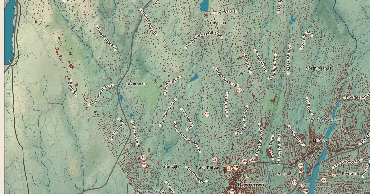
If you grew up in Greenwich, whether in Cos Cob, Riverside, Old Greenwich, Glenville or Byram, you’ll find your town on this map just as it stands in 2026. Look for your road. North Street, Old Mill Road, Locust Road, Summit Road, Stanwich Road, Moreland Road, Dewart Road, Pine Ridge Road, Clapboard Ridge Road and Byfield Road are all printed by name, along with many more.
Greenwich is in Fairfield County, at the southernmost and westernmost tip of Connecticut, between Stamford and New York City.
KNOWOL made this map in 2026 from public survey data, and gave it the look of an old atlas. The shaded hills, from North Greenwich down to Greenwich Cove and Long Island Sound, come from United States Geological Survey elevation data. The streets and the town line come from the Census Bureau, right down to small roads like Valley Road. North Greenwich, Riversville, Mianus, Glenville, Old Greenwich, Cos Cob and Belle Haven are all printed by name. A guide of 34 numbered landmarks runs along the bottom, with the National Historic Landmark and the National Register sites marked, and we checked those against National Park Service records.
Twenty-Five Coats
In 1640 Robert Feake and Captain Daniel Patrick, who came from Watertown, Massachusetts, bought the land from the Siwanoy people for 25 English coats. That’s the year on the title panel: Founded 1640. One of the founders was Elizabeth Fones Winthrop Feake, and what’s now Greenwich Point was long called “Elizabeth’s Neck” for her purchase of the point and much of today’s Old Greenwich. The town was named for Greenwich, near London. Its oldest settlement was Sound Beach, and the village in the center of town came to be called Horseneck, after a pasture where settlers kept their horses.
During the Revolution, on February 26, 1779, General Israel Putnam escaped the British here by riding down Put’s Hill, and he was able to warn Stamford. The scene is on the town seal. In the 1800s the railroad made Horseneck a suburb of New York, and in 1854 it became the Borough of Greenwich.
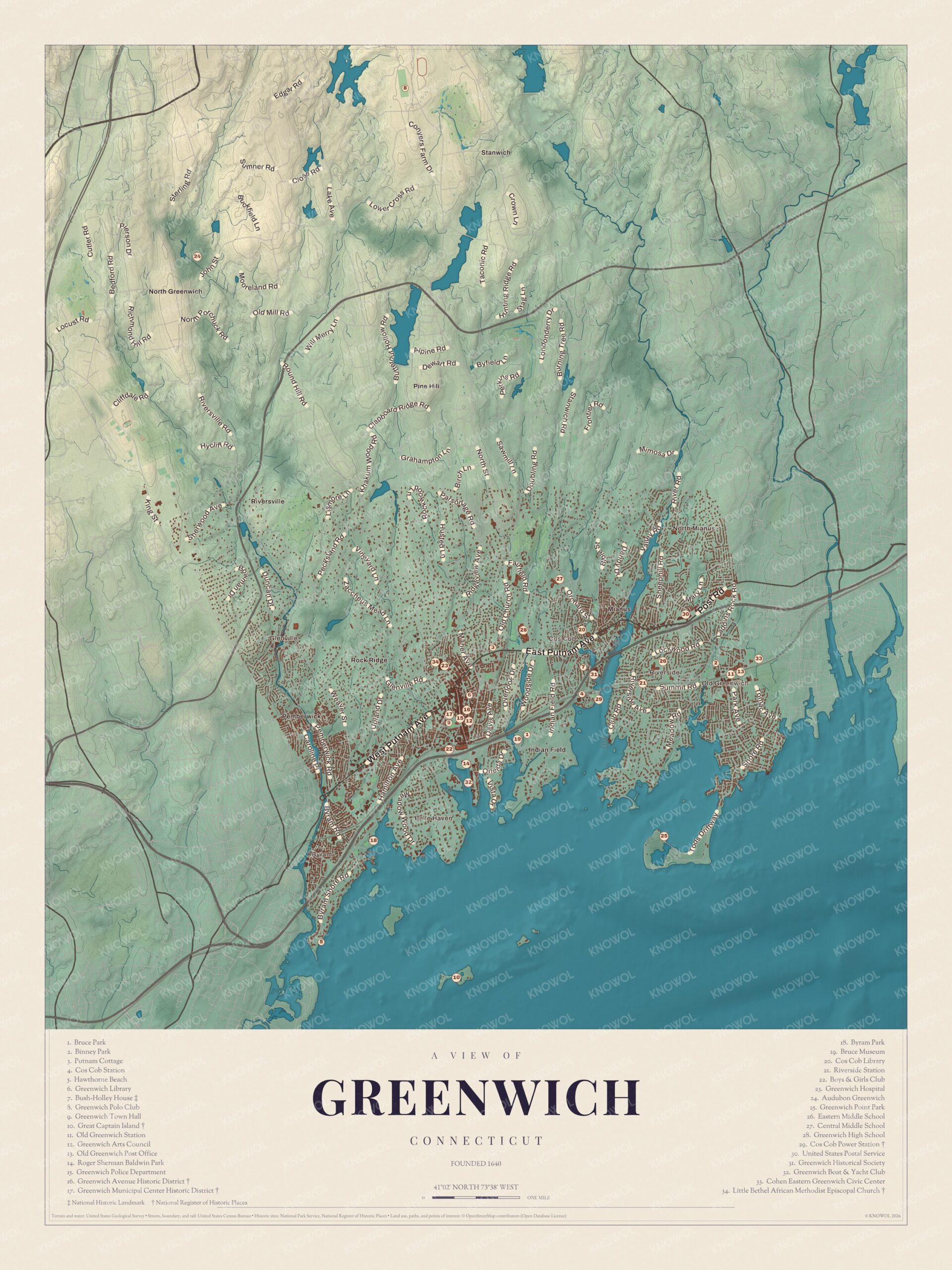
Click to explore a larger preview. The digital watermark does not appear on printed maps.
Names on this map
These names are printed on this map.
Places: North Greenwich, Old Greenwich, Great Captain Island, Riverside, Glenville, Stanwich, Audubon Greenwich, Belle Haven, Binney Park, Boys & Girls Club, Bruce Museum, Bruce Park, Bush-Holley House, Byram Park, Central Middle School, Cohen Eastern Greenwich Civic Center, Cos Cob Library, Cos Cob Power Station, Eastern Middle School, Greenwich Avenue Historic District, Greenwich Boat & Yacht Club, Greenwich High School, Greenwich Historical Society, Greenwich Hospital, Greenwich Library, Greenwich Municipal Center Historic District, Greenwich Point Park, Greenwich Polo Club, Greenwich Town Hall, Hawthorne Beach, Indian Field, Little Bethel African Methodist Episcopal Church, North Mianus, Pine Hill, Rock Ridge, Roger Sherman Baldwin Park and United States Postal Service.
Streets and roads: Old Mill Rd, Will Merry Ln, Sterling Rd, Pierson Dr, Cutler Rd, John St, Bedford Rd, Pine Rd, Farm Dr, Taconic Rd, Ridge Rd, Londonderry Dr.
More street names, A to Z
Belle Ave, Husted Ln, Lockwood Rd, Overlook Dr, Pecksland Rd, Post Rd, River Rd, Sheephill Rd, Sherwood Ave, Shore Rd, Stanwich Rd, Summit Rd, Tods Driftway, Vineyard Ln.
Downtown and Greenwich Avenue
The cluster of numbers near Greenwich Harbor is downtown Greenwich. The Greenwich Avenue Historic District (16) runs the whole length of Greenwich Avenue, from Putnam Avenue down to the railroad tracks, where the New Haven Railroad’s Greenwich station spurred the town’s growth. Its shops and offices went up in the late 1800s and early 1900s, and it was listed on the National Register in 1989. Within it is the Greenwich Municipal Center Historic District (17), listed the year before for its Classical Revival town buildings around Havemeyer Field. Henry O. Havemeyer gave the town the Havemeyer Building, first a school, in 1892, and Robert M. Bruce and his sister Sarah gave the Old Town Hall of 1905.
Greenwich Town Hall (9), the Greenwich Library (6), the Greenwich Arts Council (12) and the Greenwich Police Department (15) are close by, and Roger Sherman Baldwin Park (14) is to the south, toward the harbor. The guide also lists the United States Postal Service (30), and the post office building downtown dates from 1916.
The Bruce Museum (19) sits on a hill in a downtown park, beside Bruce Park (1). Robert Moffat Bruce, a textile merchant, bought the house in 1858 and gave it to the town in 1908 “as a natural history, historical and art museum, for the use and benefit of the public.” Today it shows art, science and natural history, including work by the Cos Cob artists.
Putnam Hill and the North
Putnam Cottage (3), on East Putnam Avenue along the old Boston Post Road, was Knapp’s Tavern during the Revolution. George Washington stopped there for lunch with his troops in 1776, and Putnam’s escape took place close by. The Daughters of the American Revolution have cared for it since 1910. Greenwich High School (28) and Central Middle School (27) are to the north. The Little Bethel African Methodist Episcopal Church (34), across from Greenwich Hospital (23), was founded in 1882 as Greenwich’s first African American congregation of any denomination. Its present church was built in 1921 and listed on the National Register in 2010. Far to the north are the Greenwich Polo Club (8) and Audubon Greenwich (24).
Cos Cob and Riverside
Cos Cob is printed by name on the harbor where the Mianus River meets the Sound. The Bush-Holley House (7), a National Historic Landmark, was built about 1730 on a hill above the harbor. From 1890 to 1920 it was a boarding house and the center of the Cos Cob Art Colony, Connecticut’s first art colony, where students came to study with the American Impressionists John Henry Twachtman, J. Alden Weir, Theodore Robinson and Childe Hassam. The Historical Society of the Town of Greenwich runs it today, and the guide also lists the Greenwich Historical Society (31).
Cos Cob Station (4) and the Cos Cob Library (20) are close by. The Cos Cob Power Station (29) marks the site of a power plant built in 1907 for the first mainline railroad electrification in the United States. It was listed on the National Register in 1990 and taken down in 2001, and part of its site is now a public park. To the east, Riverside Station (21) and Eastern Middle School (26) are in Riverside.
Old Greenwich and the Islands
Old Greenwich is printed by name in the east, with Old Greenwich Station (11), Binney Park (2), the Cohen Eastern Greenwich Civic Center (33) and the Old Greenwich Post Office (13). Greenwich Point Park (25), the old Elizabeth’s Neck, reaches out into the Sound, and the Bruce Museum keeps a Seaside Center there.
Off the shore is Great Captain Island (10), carrying a Register mark in the guide. The island includes the southernmost point in Connecticut, and it’s home to the Great Captain Island Light, built of granite in 1868 and listed on the National Register in 1991. The town has owned the island since 1973 and runs a summer ferry to it. Byram Park (18) is at the western end of town, near Belle Haven, and the guide also lists Hawthorne Beach (5), the Boys & Girls Club (22) and the Greenwich Boat & Yacht Club (32).
This map of Greenwich makes a handsome addition to a living room, office, library or den, and it can even help teach children the geography and history of the town. It’s a thoughtful gift for anyone who calls Greenwich home, grew up here, or moved away. Created by KNOWOL in 2026, it’s printed on museum quality archival paper in three sizes. Zoom in on the preview above to explore the details, then click here to get your copy of the Greenwich map.

Sources
- Greenwich, ConnecticutHistory.org
- Greenwich, Connecticut, Wikipedia
- Greenwich Avenue Historic District, Wikipedia
- Bruce Museum, Wikipedia
- Putnam Cottage, Wikipedia
- Little Bethel AME Church, Wikipedia
- Bush-Holley House, Wikipedia
- Cos Cob art colony, Wikipedia
- Cos Cob Power Station, Wikipedia
- Great Captain Island, Wikipedia
- Great Captain Island Light, Wikipedia