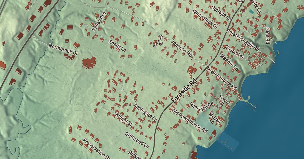
Foreside Road is the street to follow on this map of Falmouth Foreside, Maine. Underwood Road, Johnson Road, Applegate Lane, Hedgerow Road and Knight Street fill in the rest. Click here to purchase a print of this map for your wall.
Falmouth Foreside is a named community in the town of Falmouth, Cumberland County, with 1,554 people at the 2020 census.
KNOWOL made this map in 2026 from public survey data and gave it the look of an old atlas. The community is mapped with its own boundary, the census-designated place the Census Bureau draws for Falmouth Foreside, which measures 1.7 square miles with 0.15 square miles of water, and the finished artwork gives Falmouth Foreside its own place title. United States Geological Survey elevation data shades the ground, which has a listed elevation of 115 feet.
The Foreside
Falmouth Foreside is the northern of two census-designated places in the eastern part of Falmouth; the other, Falmouth, lies to the south. Arthur Mackworth, its first European resident, lived on the east bank of the Presumpscot River as early as 1630, and when Massachusetts took control of Maine in 1658 the area was renamed Falmouth. It was formally incorporated on November 12, 1718. In 1698 a palisaded fort and trading post, Fort Casco, was built on what is now Route 88, opposite Pine Grove Cemetery, at the request of local Abenaki who wanted a convenient place to trade and repair tools and weapons.
Foreside Road is State Route 88, which runs north from U.S. Route 1 in Falmouth to Yarmouth and was once called the Atlantic Highway. It keeps to the east of Route 1 the whole way, and in its Falmouth Foreside section it gets as far as about half a mile from it. Near the bay it crosses Mill Creek, once called Felt’s Brook for George Felt, a large landowner in the 1600s; a plaster mill stood just south of the crossing, at the end of today’s Old Mill Road, for 140 years.
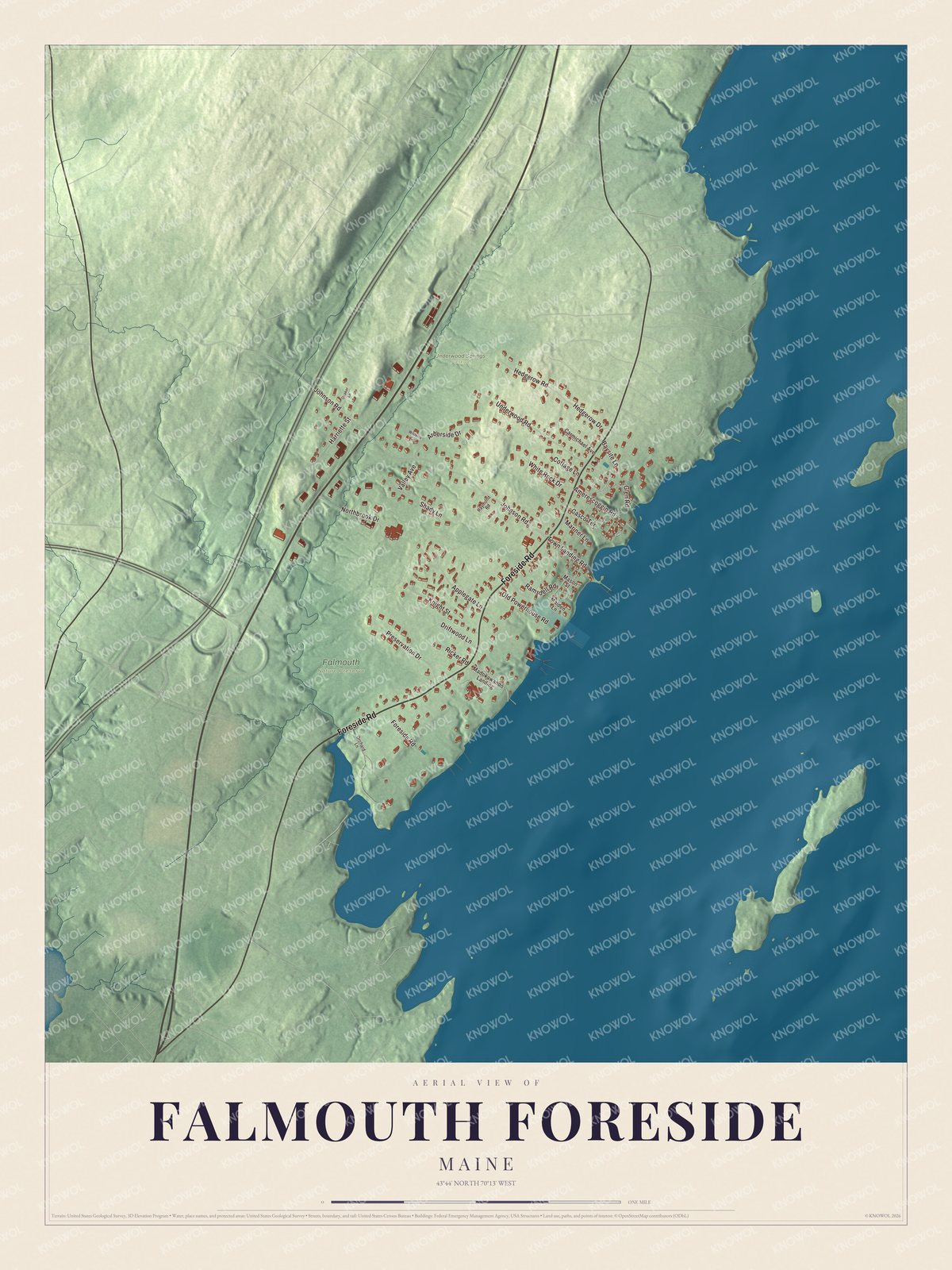
Click to explore a larger preview. The digital watermark does not appear on printed maps.
See it on a wall
The Falmouth Foreside map as a framed print. Swipe for more.


Trolleys and summer people
Trolley service from Portland reached the Foreside in 1898 and began turning the rural town toward Portland, and the Foreside into a place where city people came to relax. To promote its line, the Portland and Yarmouth Electric Railway opened Underwood Spring Park north of the town landing on July 18, 1899, a resort overlooking Casco Bay with an open-air theater, a casino and a gazebo, with cars to and from Portland every fifteen minutes. The theater burned in 1907 and the park closed, and the trolleys stopped running in 1933, but the Underwood name lives on nearby in Underwood Park and the Underwood Springs Forest Preserve, both on the inland side of Route 88.
Until the early 1900s the Foreside was mostly farmland, but by 1910 landowners were selling coastal lots for estates. Portland insurance executive Ralph S. Norton built a summer house on a high point above the bay, designed in 1912 by John Calvin Stevens and his son John Howard Stevens; the Norton House Historic District on Foreside Road was listed on the National Register of Historic Places in 2004. Part of the old Norton estate is now the grounds of the Portland Yacht Club, founded in 1869 and called by its page the “third-oldest yacht club in continuous operation in the United States.” On Foreside Road at Town Landing Road, Town Landing Market has been in business under one name or another since 1880, first serving the summer cottages along the road. It became known for a sign selling “fresh native ice cubes,” and in 1991 it appeared in a national Coca-Cola commercial.
Around Falmouth Foreside
Merle Nelson, who served five terms in the Maine House of Representatives and helped establish the Seeds of Peace summer camp, makes her home in Falmouth Foreside. Foreside Road is printed on the map, and so are Underwood Road, Johnson Road, Applegate Lane, Hedgerow Road and Knight Street. Underwood Road shares its name with the old spring park, and the community’s other streets and lanes are drawn in as well.
This Falmouth Foreside map makes a fine addition to an office, library or den, and it can help teach children the geography and history of the area. It’s made for everyone who calls Falmouth Foreside home, from Foreside Road to Knight Street, as it looks today. Zoom in on the preview above to explore the details, then click here to get your copy of the Falmouth Foreside, Maine map.

Sources