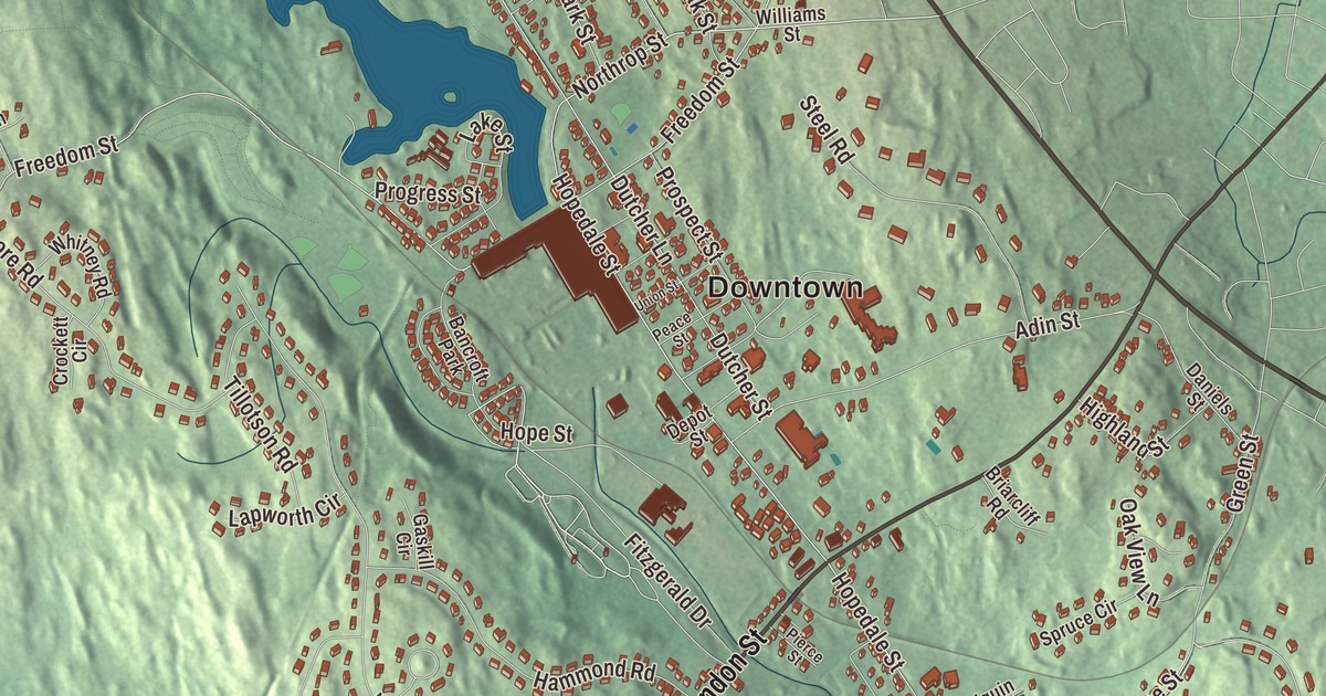
Hopedale’s center grew up around a mill pond and a loom works. This map prints South Main Street, West Street, Mendon Street, Hopedale Street, Northrop Street and Freedom Street, with Hopedale Pond, Milford Pond, Mill Pond, Bear Hill and Magomiscock Hill. Click here to purchase a print of this map for your wall.
Hopedale is in Worcester County.
KNOWOL made this map in 2026 from public survey data and gave it the look of an old atlas. The relief comes from United States Geological Survey elevation data, and the streets and the town line come from the Census Bureau. Hopedale covers 5.3 square miles in the Blackstone Valley, about 25 miles southwest of Boston, and it’s part of the Blackstone River Valley National Heritage Corridor, though much of the town drains to the Charles River. It had 6,017 people at the 2020 census.
A Christian community in Milford
The Town of Hopedale’s recorded history, in the Secretary of the Commonwealth’s list, dates European settlement to 1660. Benjamin Albee built a mill at what is now the south end of town in 1664. The land belonged first to Mendon, a 64-square-mile town in the Blackstone Valley, and then to Milford, which split from Mendon in 1780.
Hopedale’s own story begins with Adin Ballou, a Universalist and Unitarian minister who preached Christian nonresistance and worked for the immediate end of slavery. On August 26, 1841, Ballou and his fellow Practical Christians gave the name Hopedale to their land inside Milford, and the town page dates the Hopedale Community itself to 1842. Ballou wanted a community that blended a factory village with a church fellowship, without walling itself off from the world. According to the community’s page, it stood for temperance, abolition, women’s rights and education. Leo Tolstoy later admired Ballou’s writings on nonviolence and cited him as a major influence. His page notes that Hopedale still keeps streets named Peace, Hope, Freedom and Union. One of them, Freedom Street, is among the roads printed here. A statue of Ballou stands in Adin Ballou Park, along with a doorstep and boot scraper from the first settlers’ farmhouse.
The Drapers and the looms
The commune went bankrupt in 1856, and Ebenezer and George Draper, loom makers, bought its assets. Under the Draper brothers various industries grew up, including the Hopedale Machine Company and the Hopedale Furnace Company. At its peak, the Draper Corporation was the largest maker of textile looms in the United States. Its Northrop loom came from James Henry Northrop, a mechanic from Keighley, England, who worked for George Draper and Sons and invented a shuttle-charging mechanism for an automatic loom. The Northrop loom refilled itself without stopping, and with it one weaver could run 16 or more looms instead of eight. By 1900 the company had sold more than 60,000 of them.
Hopedale became a separate town in 1886, when it split from Milford. George Draper designed and paid for the town hall, built of Milford granite and sandstone and dedicated in 1887. The Drapers also gave the Unitarian church, a plant superintendent gave the Bancroft Memorial Library, and the Drapers paid for the marble sculpture outside the library, shipped from Rome in 1904. George’s son Eben Sumner Draper, born in Hopedale in 1858, served as the 44th governor of Massachusetts from 1909 to 1911. The Draper factory closed on August 29, 1980, and demolition of the old plant began in 2020; only a few outbuildings remain.
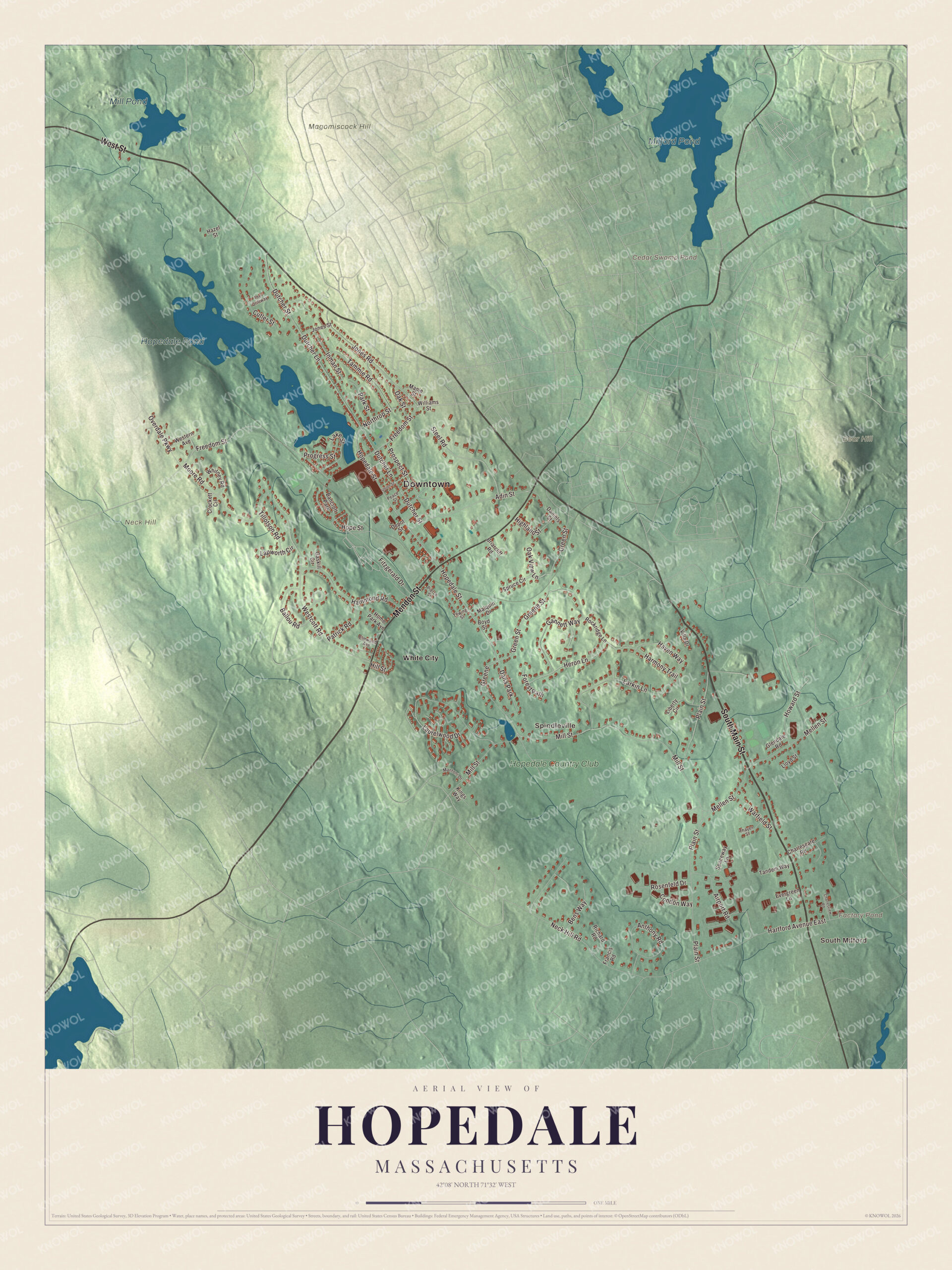
Click to explore a larger preview. The digital watermark does not appear on printed maps.
Names on this map
These names are printed on this map.
Places: Downtown, South Milford, Spindleville, Bear Hill, Magomiscock Hill, Neck Hill, Cedar Swamp Pond, Factory Pond, Milford Pond, Hopedale Pond, Mill Pond, White City, Hopedale Country Club, Dana Park and Bancroft Park.
Streets and roads: South Main Street, West Street, Mendon Street, Hopedale Street, Northrop Street, Freedom Street, Greene, Dutcher Lane, Dutcher Street, Plain Street, Mill Street, Green Street.
More street names, A to Z
Adin Street, Airport Road, Anthony Road, Ballou Road, Bens Way, Boyd Street, Briarcliff Road, Charlesgate Road, Charlesview Road, Condon Way, Crockett Circle, Cutler Street, Daniels Street, Depot Street, Elmwood Avenue, Evergreen Lane, Fitzgerald Drive, Forest Path, Francis Road, Gannett Way, Gaskill Circle, Glendale Road, Greene Street, Hammond Road, Harmony Trail, Hartford Avenue East, Haven Way, Hazel Street, Heron Lane, Highland Street, Hill Street, Home Park Avenue, Hope Street, Howard Street, Inman Street, Jones Road, Jones Street, Kings Way, Lake Street, Lapworth Circle, Larkin Lane, Laurelwood Drive, Liberty Circle, Lloyd Street, Malquin Drive, Mantoni Drive, Maple Street, Mellen Street, Moore Road, Neck Hill Road, Oak Street, Oak View Lane, Overdale Parkway, Park Street, Patrick Road, Peace Street, Pierce Street, Progress Street, Prospect Street, Richard Road, Rockridge Lane, Rosenfeld Drive, Spaceway Lane, Spruce Circle, Steel Road, Tammie Road, Tandem Way, Thayer Street, The Driftway, Thwing Street, Tillotson Road, Union Street, Villa Drive, Warfield Street, Westcott Road, Western Avenue, Whitney Road, Williams Street.
Around the map
Start with South Milford, then follow South Main Street, West Street, Mendon Street, Hopedale Street, Northrop Street and Freedom Street across town. Look outward toward Spindleville and White City. Milford Pond, Hopedale Pond, Mill Pond, Bear Hill, Magomiscock Hill, Neck Hill, Cedar Swamp Pond and Factory Pond are all printed on the map, and every one of those names is right there on the artwork. Hopedale Pond, the largest body of water in town, sits close to the center inside the Parklands, a 275-acre nature reserve with walking trails laid out in 1899 by a firm run by Frederick Law Olmsted. The Hopedale Village Historic District, on the National Register since 2002, centers on the old Draper mill site at Hopedale and Freedom streets and takes in the mill pond and homes along Mendon Street.
The Hopedale map makes a fine addition to an office, library or den, and it can help teach children the geography and history of a town that began as a hope for a better society. It’s made for people who call Hopedale home, from Spindleville to South Milford, and it shows the town as it looks today. Zoom in on the preview above to explore the details, then click here to get your copy of the Hopedale, Massachusetts map.

We made a map for every town and city in Massachusetts. Explore the complete Massachusetts map collection and find your town.
Sources
- Hopedale, Massachusetts, Wikipedia
- Adin Ballou, Wikipedia
- Hopedale Community, Wikipedia
- Draper Corporation, Wikipedia
- Northrop Loom, Wikipedia
- James Henry Northrop, Wikipedia
- Eben Sumner Draper, Wikipedia
- Hopedale Village Historic District, Wikipedia
- City and Town Incorporation and Settlement Dates, Secretary of the Commonwealth of Massachusetts (archived copy)