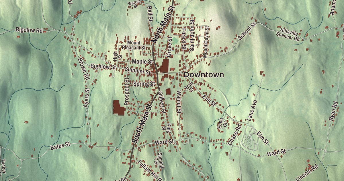
George M. Cohan once told a reporter there was no place like North Brookfield. On this map North Main Street and South Main Street run through the center, with West Brookfield Road, Oakham Road, North Brookfield Road and New Braintree Road heading out toward Lake Lashaway, Brooks Pond and Bell Hill. Click here to purchase a print of this map for your wall.
North Brookfield is in Worcester County.
KNOWOL made this map in 2026 from public survey data, with the look of an old atlas page. United States Geological Survey elevation data shapes the hills, and the Census Bureau supplied the streets and the town line. The town covers 21.7 square miles and had 4,735 people at the 2020 census. Spencer lies to the east, East Brookfield and Brookfield to the south, West Brookfield to the west and New Braintree to the north. In the northeast corner four towns meet, North Brookfield, Spencer, New Braintree and Oakham, but Brooks Pond cuts that point off from the rest of the town.
Out of the Quaboag Plantation
The town’s land was once part of the Quaboag Plantation, which John Pynchon of Springfield bought in 1660 for a settlement about halfway between Boston and Springfield, named for the Quaboag people, with whom his father, William Pynchon, had long done business. Twenty families from Ipswich came to settle it. The Town of North Brookfield’s recorded history, in the Secretary of the Commonwealth’s list, dates European settlement to 1664. North Brookfield was incorporated as a town in 1812, when it split from Brookfield; West Brookfield and East Brookfield were later carved from Brookfield’s land too. Its Town House at 185 North Main Street went up in 1864, a wood-frame building trimmed in Italianate and Second Empire style, with a 60-foot tower on the corner of North Main and Summer Streets. It’s the town’s third town hall and joined the National Register in 2001. The public library dates to 1879.
Summers in North Brookfield
As a boy, Cohan spent summers off the vaudeville circuit at his grandmother’s home in North Brookfield, where he befriended the baseball player Connie Mack, and the family generally put on a show at the town hall each summer. Those summers inspired his 1907 musical 50 Miles from Boston, set in North Brookfield, which includes his song “Harrigan.” When he came back in 1934 in the cast of Ah, Wilderness!, he told a reporter, “I’ve knocked around everywhere, but there’s no place like North Brookfield.”
The economist Amasa Walker moved to North Brookfield with his parents as a boy and started in business here in 1820. He later helped found the Free Soil Party in 1848, served as Massachusetts Secretary of the Commonwealth from 1851 to 1853, and went to Congress. His son Francis Amasa Walker moved here with the family at age three, came back to recover from his Civil War wounds, ran the 1870 and 1880 censuses, published the first Statistical Atlas of the United States, a work that used maps to report the census, and became the third president of MIT. He’s buried in Walnut Grove cemetery in North Brookfield. The poet Abbie M. Gannett was born here in 1845, and her book of poems, The Old Farm Home, reflects her love of the countryside and her early years.
On the north shore of Lake Lashaway, Dr. William N. DeBerry founded Camp Atwater in 1921, first called St. John’s Camp, to give African American boys a summer camp at a time when most camps were segregated. It drew campers from up and down the Atlantic coast, among them Coleman Young, Hazel O’Leary and Clifton Wharton Jr., and joined the National Register in 1982. Long View Farm, a recording studio a Clark University professor opened on his farm in 1974, hosted the Rolling Stones for rehearsals in 1981. The town remains part of Worcester County today.
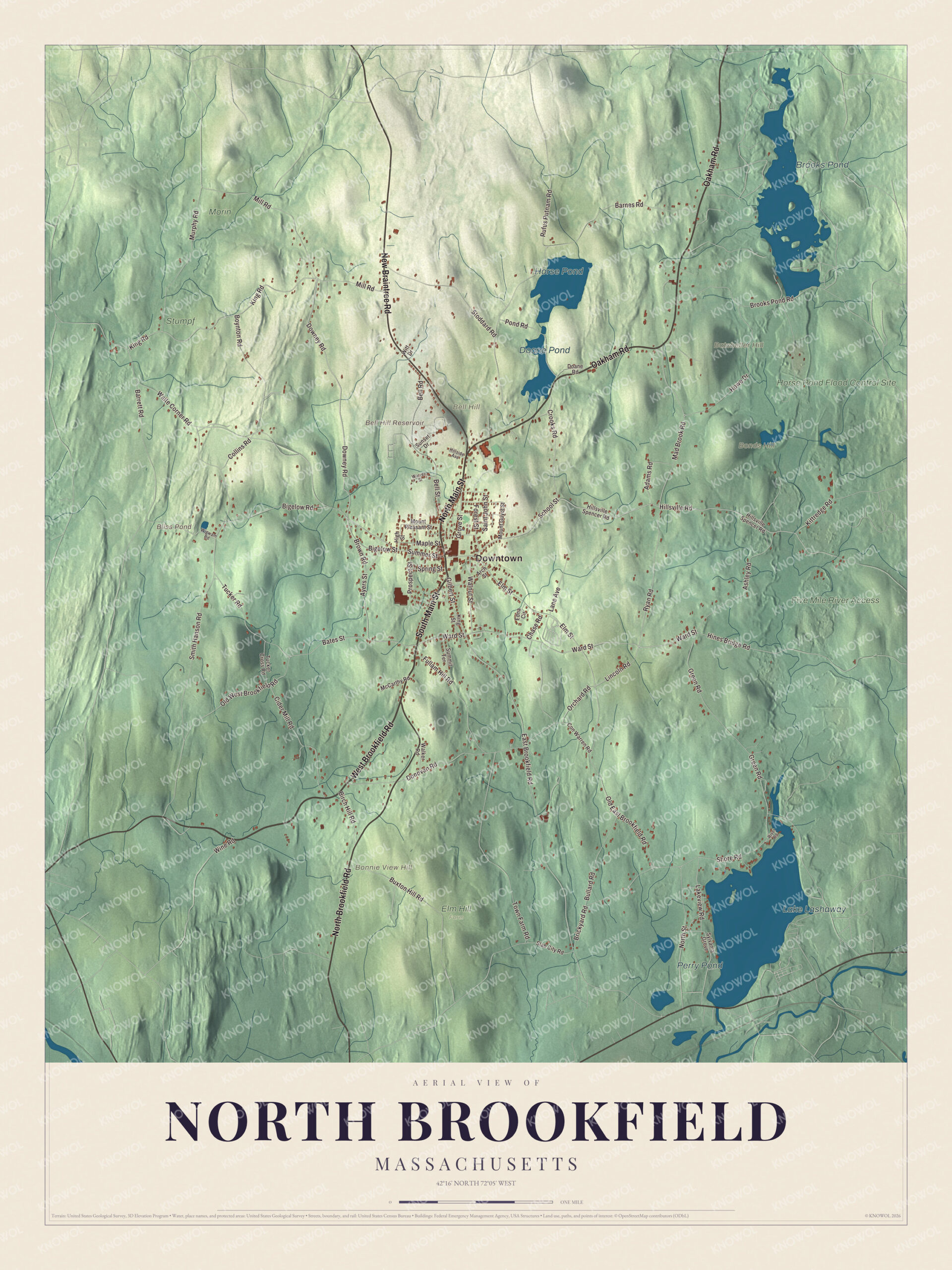
Click to explore a larger preview. The digital watermark does not appear on printed maps.
Names on this map
These names are printed on this map.
Places: Downtown, Batcheller Hill, Bell Hill, Bonds Hill, Bonnie View Hill, Bell Hill Reservoir, Bliss Pond, Lake Lashaway, Brooks Pond, Horse Pond, Doane Pond, Perry Pond, Five Mile River Access, Horse Pond Flood Control Site, Elm Hill Farm, Morin and Stumpf.
Streets and roads: South Main Street, North Main Street, West Brookfield Road, Oakham Road, North Brookfield Road, New Braintree Road, Summer Street, School Street, Downey Road, King Road, Ward Street, Ashley Road.
More street names, A to Z
Adams Road, Arch Street, Ayers Street, Barnes Road, Barrett Road, Bates Street, Bell Road, Bell Street, Bigelow Road, Bigelow Street, Birch Hill Road, Boynton Road, Brickyard Road, Brooks Pond Road, Brown Road, Bullard Road, Buxton Hill Road, Chase Road, Cider Mill Road, Collins Road, Con Warren Road, Crooks Road, Doane Road, Donovan Road, East Brookfield Road, Edna Circle, Elm Street, Forest Street, Fullam Hill Road, Gilbert Street, Green Road, Grove Street, High Street, Hillside Avenue, Hillsville Road, Hillsville Spencer Road, Hines Bridge Road, Howe Drive, King Street, Kittredge Road, Lakeview Road, Lane Avenue, Lincoln Road, Mad Brook Road, Maple Street, McCarthy Road, Mill Road, Mount Guyot Street, Mount Pleasant Street, Murphy Road, North Street, Old East Brookfield Road, Old West Brookfield Road, Orchard Road, Pond Road, Prospect Street, River Road, Rufus Putnam Road, Ryan Road, Saint John Street, Shore Road, Slab City Road, Smith Hanson Road, Spring Street, Stoddard Road, Summit Terrace, Sunset Drive, Sylvania Grove, Town Farm Road, Tucker Cross Road, Tucker Road, Waite Corner Road, Walker Road, Walnut Street, Warren Street, Wigwam Road, Wine Road, Witt Drive.
See it on a wall
The North Brookfield map as a framed print. Swipe for more.


Around the map
Start at the Town House. Follow South Main Street, North Main Street, West Brookfield Road, Oakham Road, North Brookfield Road and New Braintree Road across town. Bliss Pond, Lake Lashaway, Brooks Pond, Horse Pond, Batcheller Hill, Bell Hill, Bonds Hill and Bell Hill Reservoir are all printed on the map. Lake Lashaway is a man-made lake with the East Brookfield and North Brookfield town lines running through it. Jeduthan Stevens dammed the stream for his mills in the years after about 1825, and the lake was first known as Stevens Pond. Brooks Pond is bordered by North Brookfield, Oakham, Spencer and New Braintree, and its dam raised it to roughly its present size in 1848. It’s the headwaters of the Five Mile River.
The North Brookfield map looks fine in an office, library or den, and it can help teach children the geography and history of a small town in central Massachusetts. It’s made for anyone who calls North Brookfield home, from North Main Street to the shore of Lake Lashaway, and it shows the town as it looks today. Zoom in on the preview above to explore the details, then click here to get your copy of the North Brookfield, Massachusetts map.

Sources
- North Brookfield, Massachusetts, Wikipedia
- Quaboag Plantation, Wikipedia
- Brookfield, Massachusetts, Wikipedia
- North Brookfield Town House, Wikipedia
- George M. Cohan, Wikipedia
- Amasa Walker, Wikipedia
- Francis Amasa Walker, Wikipedia
- Abbie M. Gannett, Wikipedia
- Camp Atwater, Wikipedia
- Long View Farm Studios, Wikipedia
- Lake Lashaway, Wikipedia
- Brooks Pond (Massachusetts), Wikipedia
- City and Town Incorporation and Settlement Dates, Secretary of the Commonwealth of Massachusetts (archived copy)