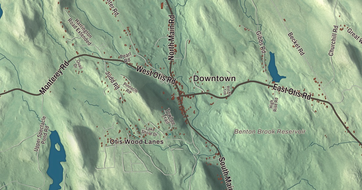
Otis lies in the southern Berkshires, where most people live around the reservoir or in the town center. This map prints its roads, North Main Road, South Main Road, East Otis Road, West Otis Road, Monterey Road and Becket Road, with Otis Reservoir, Big Pond and Abbey Lake. Click here to purchase a print of this map for your wall.
Otis is in Berkshire County.
KNOWOL made this map in 2026 from public survey data and gave it the look of an old atlas. United States Geological Survey elevation data raises the hills, and the Census Bureau supplied the streets and the town line. Otis covers 38.0 square miles on Berkshire County’s eastern border with Hampden County and had 1,634 people at the 2020 census. Becket lies to the north, Blandford to the east, Tolland to the southeast, Sandisfield to the south, and Monterey and Tyringham to the west. The highest ground is in the north, with Church Hill to the east and Kingsbury Mountain to the west, and much of the land around the brooks is marshy.
Loudon and Bethlehem
The Town of Otis’ recorded history, in the Secretary of the Commonwealth’s list, dates European settlement to 1735. The state’s list says Otis was incorporated as a town in 1773. The town page tells it another way: the town of Loudon annexed the neighboring District of Bethlehem in 1809, and the combined town was incorporated in 1810 as Otis, named after Harrison Gray Otis, a Boston lawyer, financier and Federalist leader of the Revolutionary era. In January 1776 Colonel Henry Knox passed through with cannons from Fort Ticonderoga, hauled by oxen across the snowy Berkshires to help end the Siege of Boston. Route 23, which crosses Otis, is known as the Knox Trail, with a historical marker in the eastern part of town.
Otis was a farming community, with small mills along its waterways, and today it’s mostly rural with some tourism. The town hall, police and fire departments, library and post office are all at the town center. The West Branch of the Farmington River rises in Otis, at the outlet of Hayden Pond, and heads south. Otis Ridge, just west of the center, opened as a ski area in 1946 with two surface lifts and a single trail. The town remains part of Berkshire County today.
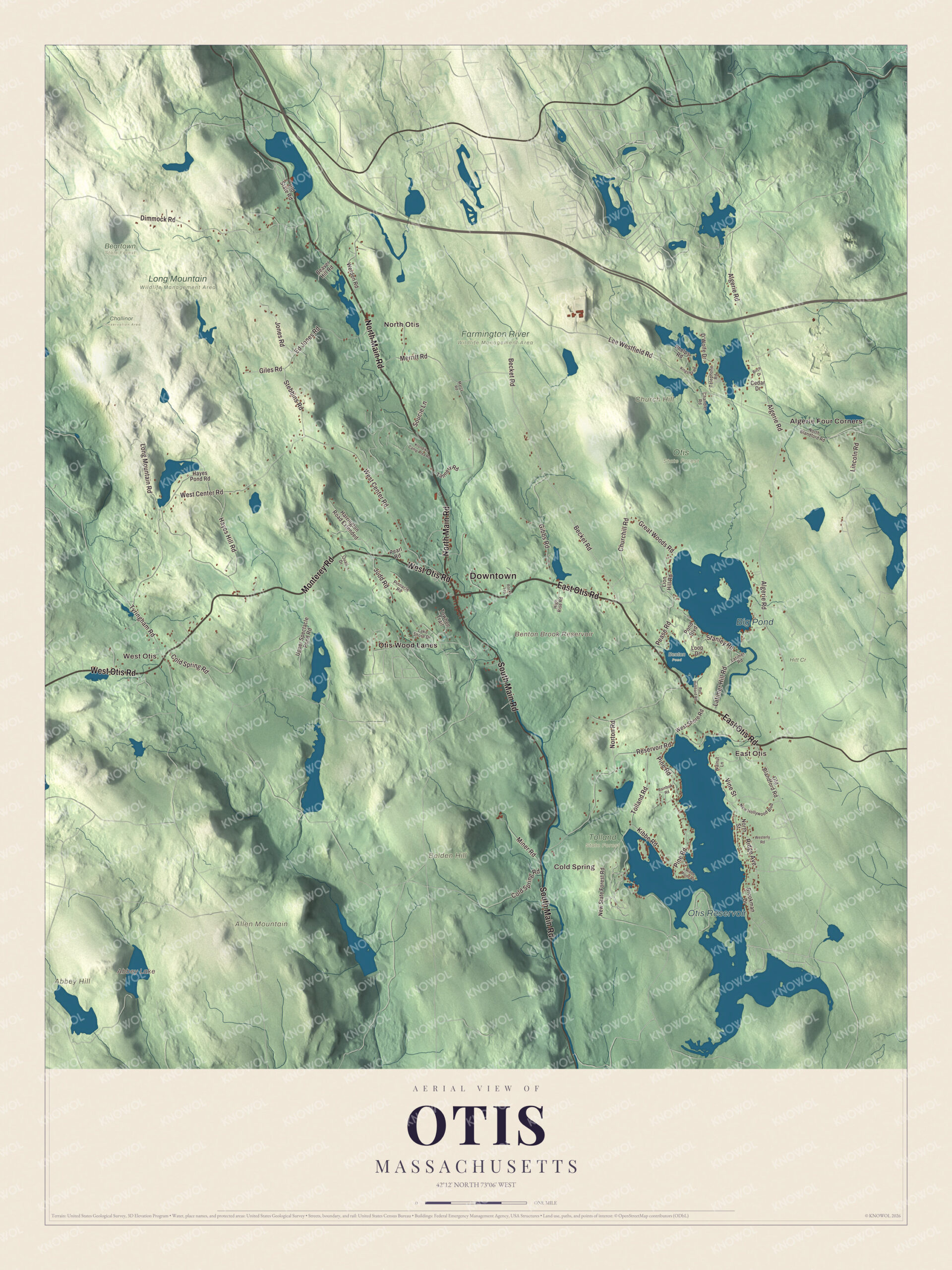
Click to explore a larger preview. The digital watermark does not appear on printed maps.
Names on this map
These names are printed on this map.
Places: Downtown, Algerie Four Corners, East Otis, West Otis, Cold Spring, North Otis, Abbey Hill, Allen Mountain, Belden Hill, Church Hill, Abbey Lake, Benton Brook Reservoir, Otis Reservoir, Big Pond, Beartown State Forest, Benton Pond, Challinor Conservation Area, Farmington River Wildlife Management Area, Hitt Cr, Long Mountain Wildlife Management Area, Otis State Forest, Tolland State Forest and Otis Wood Lanes.
Streets and roads: North Main Road, East Otis Road, West Otis Road, South Main Road, Monterey Road, Becket Road, Algerie Road, West Center Road, Reservoir Road, Lee Westfield Road, Hayes Hill Road, Tolland Road.
More street names, A to Z
Beaver Hill Road, Birch Drive, Brookman Drive, Cedar Drive, Chandler Road, Churchill Road, Cold Spring Road, D'Wolfe Drive, Dimmock Road, Ed Jones Road, Gibbs Road, Giles Road, Great Woods Road, Harrington Road Extended, Hayes Pond Road, High Rise Road, Jones Road, Judd Road, Kibbe Point Road, Kibbe Road, Kingsley Road, Klondike Camp Area Road, Lake Shore Drive, Latimer Hill Road, Latimer Road, Lincoln Road, Lion Hill Road, Long Mountain Road, Loop Drive, Marcy Road, Merritt Road, Miner Road, New Hollywood Boulevard, New State Forest Road, North Blandford Road, North Street, Norton Road, Old Blandford Road, Old State Road, Pearl Road, Pease Road, Phelps Road, Pine Road, Pinnacle Road, Pond Boulevard, Quail Drive, Rainbow Road, Ray Hubbard Road, Ridge Avenue, Rocky Top, Soucie Lane, Stanley Road, Stebbins Road, Tannery Road, Telephone Road, Towhee Trail, Tyringham Road, Upper Spectacle Pond Road, Vine Street, Walnut Lane, Werden Road, Westerly Road, West Shore Road.
See it on a wall
The Otis map as a framed print. Swipe for more.


Around the map
Start with Algerie Four Corners. Follow North Main Road, East Otis Road, West Otis Road, South Main Road, Monterey Road and Becket Road across town. Then look outward toward East Otis, West Otis, Cold Spring, North Otis and Otis Wood Lanes. Abbey Lake, Otis Reservoir, Big Pond, Abbey Hill, Allen Mountain, Belden Hill and Benton Brook Reservoir are all printed on the map. Otis Reservoir, mostly in Otis with small parts in Tolland and Blandford, was made in 1865 when the Farmington River Power Company dammed the Fall River and flooded Rand, Little and Messenger ponds, storing water to keep the mills along the Farmington running. Cottages went up along its shore in the early 1900s as more people came by car, and Tolland State Forest now holds about a quarter of the shoreline, with a campground the Civilian Conservation Corps built on a peninsula. Big Pond, a 330-acre lake, is in Otis too.
The Otis map is a fine addition to an office, library or den, and it can help teach children the geography and history of a town in the southern Berkshires. It’s made for anyone who calls Otis home, from Algerie Four Corners to Otis Reservoir, and it shows the town as it looks today. Zoom in on the preview above to explore the details, then click here to get your copy of the Otis, Massachusetts map.

Sources
- Otis, Massachusetts, Wikipedia
- Harrison Gray Otis (politician), Wikipedia
- Henry Knox Trail, Wikipedia
- Farmington River, Wikipedia
- Otis Ridge, Wikipedia
- Otis Reservoir, Wikipedia
- Tolland State Forest, Wikipedia
- Big Pond (Massachusetts), Wikipedia
- City and Town Incorporation and Settlement Dates, Secretary of the Commonwealth of Massachusetts (archived copy)