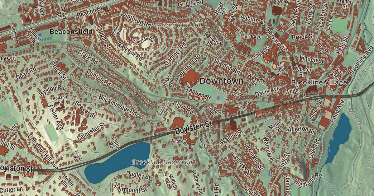
Boylston Street, which is Route 9, unofficially divides Brookline in two: north of it the town is fairly urban, and south of it much less so. This map prints Boylston Street, Beacon Street, Washington Street, Commonwealth Avenue, Saint Marys Street and the Vfw Parkway, with Brookline Village, Westbrook Village, Aspinwall Hill and the Brookline Reservoir. Click here to purchase a print of this map for your wall.
Brookline is in Norfolk County, an exclave surrounded by Boston and Newton.
KNOWOL made this map in 2026 from public survey data and gave it the look of an old atlas. The relief comes from United States Geological Survey elevation data, and the streets and the town line come from the Census Bureau. Brookline covers 6.8 square miles and borders six Boston neighborhoods, Brighton, Allston, Fenway and Kenmore, Mission Hill, Jamaica Plain and West Roxbury, with the city of Newton to the west. North of the D-line tracks the town is as dense as parts of Cambridge, and to the south it opens into suburban streets and big estates. It had 63,191 people at the 2020 census.
Muddy River becomes Brookline
The land was part of Algonquian territory before English colonists came. The Town of Brookline’s recorded history, in the Secretary of the Commonwealth’s list, dates European settlement to 1638, when it began as a hamlet of Boston called Muddy River, settled on the west side of the river of that name. Brookline was incorporated as a town in 1705, with the Muddy River as its border with Boston. The name is said to come from a farm here once owned by Judge Samuel Sewall.
Brookline has turned Boston down. In 1873 a contentious vote kept the town independent. Boston took in Brighton and West Roxbury in 1874 and Hyde Park in 1912, and those annexations left Brookline as an island of Norfolk County, which it remains today. When Brighton joined the city, Boston also took the strip of land along the Charles River, cutting Brookline off from the shoreline. Its northern line now follows Commonwealth Avenue and, to the northeast, Saint Marys Street.
A garden of a town
In 1841 the landscape writer Andrew Jackson Downing called this neighborhood “a kind of landscape garden,” full of winding lanes between cottages and villas. In 1883 Frederick Law Olmsted bought an 1810 farmhouse at 99 Warren Street and set up Fairsted, which its page calls the world’s first full-scale professional office for landscape design. Its office holds nearly a million original design records, for places from the grounds of the U.S. Capitol to Central Park and Yosemite Valley, and the site is open for tours.
Olmsted’s Emerald Necklace runs along the town’s eastern edge. In the 1890s the Muddy River was folded into the Riverway and Olmsted Park, shared by Boston and Brookline. Olmsted Park, first called Leverett Park, took his name in 1900, and it reaches south to Jamaica Pond, which lies just over the line in Boston’s Jamaica Plain. Jamaica Pond is the source of the Muddy River and the largest body of fresh water in Boston.
Presidents, firsts and an old motor collection
John F. Kennedy, the 35th president, was born in 1917 in the upstairs bedroom of the house at 83 Beals Street, near Coolidge Corner, and lived his first years in Brookline. His mother, Rose Kennedy, later restored the house, and it’s now the John Fitzgerald Kennedy National Historic Site, run by the National Park Service. Robert F. Kennedy was born in Brookline too. Coolidge Corner, where Beacon and Harvard streets cross, takes its name from the Coolidge & Brother store that opened there in 1857, and its Art Deco Coolidge Corner Theatre has been showing films since 1933.
The Country Club, formed by a group of Boston men in 1882, was the first private club in the country made only for outdoor activities, the town page says, and its own page calls it the oldest golf-oriented country club in the United States. It was one of the five clubs that founded the United States Golf Association, and in 1913 a 20-year-old former caddie named Francis Ouimet, who grew up across the street, beat the English stars Harry Vardon and Ted Ray in a playoff to win the U.S. Open there. At Larz Anderson Park, on the old 64-acre Anderson estate, the Larz Anderson Auto Museum keeps the oldest collection of motorcars in the United States, starting with an 1899 Winton. Brookline residents were among the first in the country to propose giving women the vote, and in 1936 Sybil Holmes, a Brookline town meeting member, became the first woman elected to the Massachusetts Senate. Two stops on the Underground Railroad stood in Brookline, at 9 Toxteth Street and 182 Walnut Street.
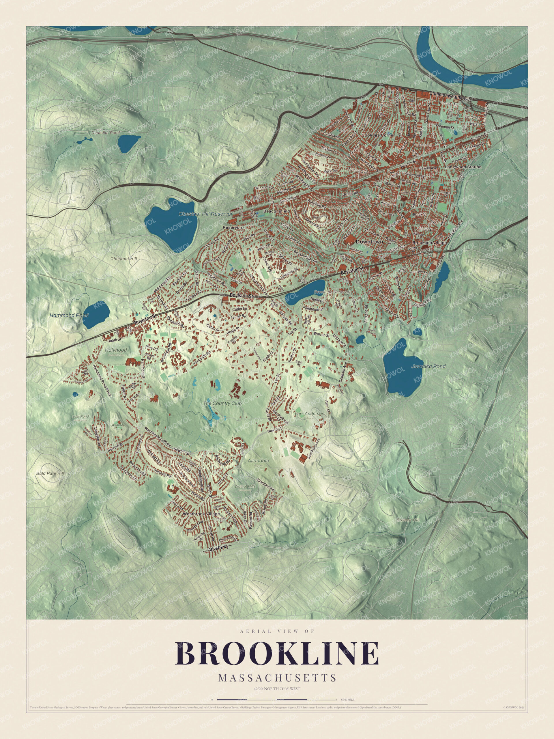
Click to explore a larger preview. The digital watermark does not appear on printed maps.
Names on this map
These names are printed on this map.
Places: Downtown, Longwood Station, Aspinwall Hill, Bald Pate Hill, Bussey Hill, Chestnut Hill, Brookline Reservoir, Chandler Pond, Chestnut Hill Reservoir, Jamaica Pond, Hammond Pond, Allandale Farm, Holyhood Cemetery, Larz Anderson Park, Lost Pond Sanctuary, Skyline Park, Walnut Hills Cemetery, Beaconsfield, Brookline Village, Coolidge Corner, Reservoir, Westbrook Village and The Country Club.
Streets and roads: Commonwealth Avenue, Vfw Parkway, Boylston Street, Beacon Street, Saint Marys Street, Washington Street, Newton Street, Grove Street, Ivy Street, Winchester Street, Monmouth Street, Walnut Street.
More street names, A to Z
Ackers Avenue, Acron Road, Addington Road, Alberta Road, Allandale Road, Allerton Street, Alton Place, Amory Street, Arlington Road, Asheville Road, Aston Road, Auburn Street, Avon Street, Babcock Street, Baker Circle, Bartlett Crescent, Beals Street, Beech Road, Beresford Road, Beverly Road, Blake Road, Bonad Road, Borland Street, Bowker Street, Brington Road, Brookline Avenue, Brook Street, Browne Street, Buckminster Road, Cabot Street, Cameron Street, Catlin Road, Cedar Road, Centre Street, Chapel Street, Chestnut Hill Avenue, Chestnut Street, Chilton Street, Claflin Road, Clark Road, Clearwater Road, Cleveland Road, Clinton Path, Clinton Road, Clyde Street, Codman Road, Colchester Street, Columbia Street, Conant Road, Coolidge Street, Corey Road, Cottage Farm Road, Cottage Street, Craftsland Road, Crafts Road, Cramond Road, Crowninshield Road, Cutler Lane, Cypress Street, Dale Street, Davis Avenue, Dean Road, Denny Road, Devon Road, Druce Street, Dudley Street, Dummer Street, Dunster Road, Elba Street, Eliot Street, Elm Street, Essex Street, Euston Street, Evans Road, Fairgreen Place, Fairmount Street, Fairway Road, Fernwood Road, Fisher Avenue, Fisher Road, Francis Street, Franklin Street, Freeman Street, Fuller Street, Gardner Road, Gerry Road, Gibbs Street, Glenoe Road, Glen Road, Goddard Avenue, Goodnough Road, Green Hill Road, Green Street, Griggs Road, Griggs Terrace, Hallwood Road, Hammond Pond Parkway, Hammond Street, Hancock Road, Harrison Street, Harvard Avenue, Harvard Street, Heath Hill, Heath Street, Hedge Road, Highland Road, High Street, Hillside Road, Hilltop Road, Holden Street, Holland Road, Holly Lane, Hyslop Road, Intervale Road, Jamaica Road, James Street, Jefferson Road, Jordan Road, Juniper Street, Kennard Road, Kent Street, Kilsyth Road, Lagrange Street, Lancaster Terrace, Laurel Road, Lawton Street, Lee Street, Leicester Street, Leland Road, Lenox Street, Linden Street, Longwood Avenue, Lyman Road, Lyon Road, Maple Street, Marion Street, Marthas Lane, Mason Terrace, Meadowbrook Road, Middlesex Road, Naples Road, Norfolk Road, Ogden Road, Orchard Road, Parkman Street, Park Street, Payson Road, Perry Street, Pine Road, Pleasant Street, Plowgate Road, Pond Avenue, Powell Street, Prince Street, Princeton Road, Randolph Road, Rangeley Road, Rawson Road, Reservoir Road, Risley Road, Rockwood Street, Russell Street, Saint Paul's Avenue, Saint Paul Street, Salisbury Road, Sargent Crossway, Sargent Road, School Street, Sears Road, Seaver Street, Sewall Avenue, Shaw Road, South Street, Spooner Road, Stanton Road, Stearns Road, Stedman Street, Stetson Street, Still Street, Strathmore Road, Summit Avenue, Sumner Road, Tappan Street, Thorndike Street, Thornton Road, Toxteth Street, Tully Street, Valley Road, Verndale Street, Vernon Street, Village Way, Wallis Road, Walnut Hill Road, Walnut Place, Warren Street, Waverly Street, Webster Place, Webster Street, Welch Road, Welland Road, Westbourne Terrace, West Roxbury Parkway, White Place, Willard Road, Windsor Road, Winslow Road, Winthrop Road, Wolcott Road, Woodcliff Road, Woodland Road, Yarmouth Road, York Terrace.
See it on a wall
The Brookline map as a framed print. Swipe for more.


Around the map
Start at Longwood Station, on Chapel Street at the Boston line, a Green Line stop since the D branch opened in 1959, then follow Commonwealth Avenue, Beacon Street, Saint Marys Street, Boylston Street, Washington Street and the Vfw Parkway across the town, and look outward toward Beaconsfield, Brookline Village, Coolidge Corner, Reservoir and Westbrook Village. Brookline Village, once called Punch Bowl Village after a tavern, is the historic center, with the town hall and public library, and its stretch of Washington Street is on the National Register. Beacon Street west of Kenmore Square was laid out in 1850, and streetcar tracks were laid on it in 1888; those lines became the Green Line’s C branch. On Boylston Street, the Brookline Reservoir was built in 1848 as the end of the Cochituate Aqueduct; its granite gatehouse is a National Historic Landmark. The Chestnut Hill Reservoir, made in 1870, lies in Boston’s Chestnut Hill section. Brookline Reservoir, Chandler Pond, Chestnut Hill Reservoir, Jamaica Pond, Aspinwall Hill, Bald Pate Hill and Bussey Hill are all printed on the map.
Brookline’s map makes a fine addition to an office, library or den, and it can help teach children the geography and history of a town that voted to stay independent. It’s made for people who call Brookline home, from Coolidge Corner to Brookline Village, and it shows the town as it looks today. Zoom in on the preview above to explore the details, then click here to get your copy of the Brookline, Massachusetts map.

Sources
- Brookline, Massachusetts, Wikipedia
- Frederick Law Olmsted National Historic Site, Wikipedia
- Olmsted Park, Wikipedia
- Jamaica Pond, Wikipedia
- John Fitzgerald Kennedy National Historic Site, Wikipedia
- Coolidge Corner, Wikipedia
- The Country Club, Wikipedia
- Larz Anderson Auto Museum, Wikipedia
- Sybil Holmes, Wikipedia
- Longwood station (MBTA), Wikipedia
- Brookline Village, Wikipedia
- Reservoir Park (Massachusetts), Wikipedia
- Chestnut Hill Reservoir, Wikipedia
- City and Town Incorporation and Settlement Dates, Secretary of the Commonwealth of Massachusetts (archived copy)