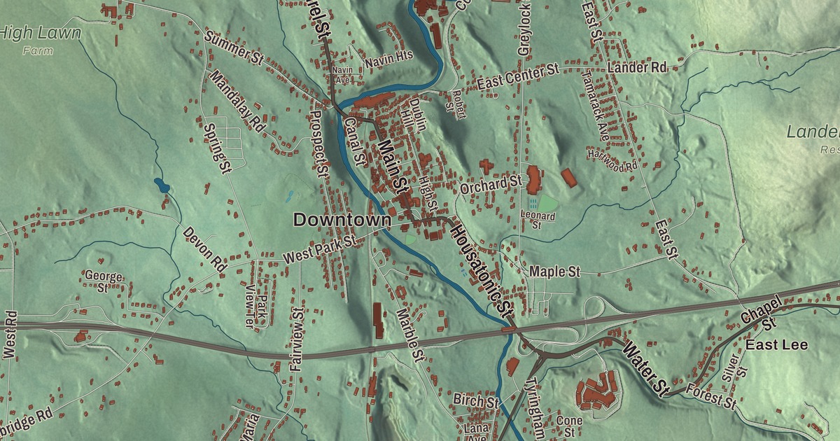
Lee lies in a valley along the Housatonic River in the southern Berkshires, and it grew up as a mill town. This map prints Main Street, Laurel Street, Housatonic Street, Water Street, Kimble Street and Cape Street, with Laurel Lake, Goose Pond, Basin Pond, Felton Lake and Lanier Hill. Click here to purchase a print of this map for your wall.
Lee is in Berkshire County.
KNOWOL made this map in 2026 from public survey data and gave it the look of an old atlas. The relief comes from United States Geological Survey elevation data, and the streets and the town line come from the Census Bureau. Lee covers 27.0 square miles, bordered by Lenox, Washington, Becket, Tyringham, Great Barrington and Stockbridge, 10 miles south of Pittsfield and 125 miles west of Boston. Lee is known as the “Gateway to the Berkshires,” and its Exit 10 is the westernmost full exit on the Massachusetts Turnpike. The town had 5,788 people at the 2020 census.
Dodgetown and a general’s name
The land was Mahican territory. The Town of Lee’s recorded history, in the Secretary of the Commonwealth’s list, dates European settlement to 1760, when the first settlement was known as Dodgetown, after its founding settler, Asahel Dodge of Cape Cod. Lee was incorporated as a town in 1777, from parts of Great Barrington and Washington, and it’s named for Charles Lee, a general in the Continental Army during the Revolution. The town remains part of Berkshire County today. In the autumn of 1786, during Shays’ Rebellion, about 250 of Daniel Shays’s followers met state troops under General John Paterson near East Lee. The Shaysites paraded a fake cannon made from a yarn beam, and the troops fled.
Paper and marble
Lee’s streams and rivers powered mills for textiles and wire, and papermaking became the main industry in 1806, when Samuel Church built the Willow Mill in South Lee. The Columbia Mill in central Lee, founded in 1827, became the first to supply newsprint made entirely of groundwood to The New York Times. By 1857 Lee had 25 paper mills. The Smith Paper Company worked out how to make paper solely from wood pulp in 1867, and through the 1870s it was the country’s largest producer of paper. The old Smith mills closed in 2008, and today the town has a single papermaking plant.
Lee’s marble is known for its quality. The first quarry opened in 1852, and in 1867 almost 500,000 cubic feet of marble went out on the Housatonic Railroad. Lee marble went into a wing of the Capitol in Washington, 250 sculptures on Philadelphia City Hall, the General Grant National Memorial and St. Patrick’s Cathedral in New York. The town hall, library, churches and homes from that prosperous century still stand. Arlo Guthrie’s court appearance for dumping garbage, the one told in the song “Alice’s Restaurant,” took place in the courtroom at the Lee Town Hall.
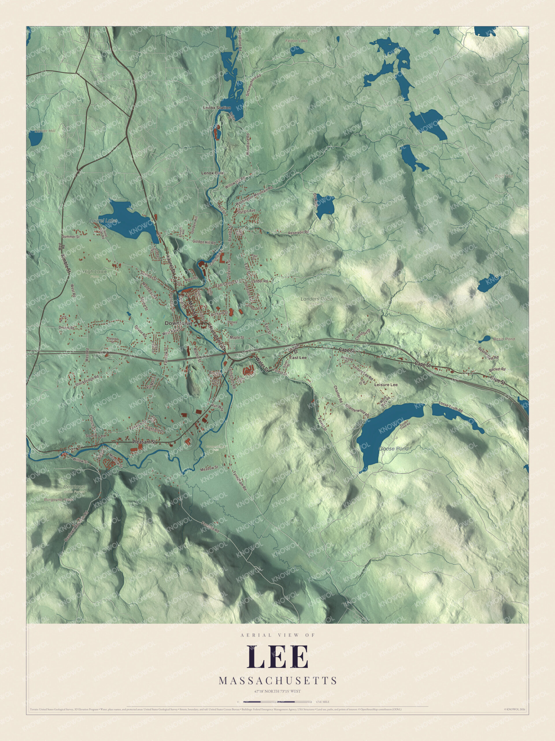
Click to explore a larger preview. The digital watermark does not appear on printed maps.
Names on this map
These names are printed on this map.
Places: Downtown, South Lee, Leisure Lee, Bald Top, Burgoyne Pass, Lanier Hill, Basin Pond, Felton Lake, Goose Pond, Laurel Lake, Beartown State Forest, Courser Brook Farm, High Lawn Farm, Landers Road Reserve, East Lee, Lenox Dale and Lenox Station.
Streets and roads: Laurel Street, Main Street, Housatonic Street, Water Street, Kimble Street, Cape Street, Pleasant Street, Forest Street, West Park Street, Summer Street, Orchard Street, Maple Street.
More street names, A to Z
Antelope Drive, Beartown Mountain Road, Beaver Dam Road, Becket Road, Birch Street, Bradley Street, Canal Street, Chanter Road, Chanterwood Road, Chapel Street, Chestnut Street, Church Street, Columbia Street, Cone Street, Cooper Creek Road, Devon Road, Dirt Path, Dublin Hill, East Center Street, East Street, Elk Drive, Fairview Street, Fernside Road, Fox Run, George Street, Golden Hill, Golden Hill Road, Greylock Street, Hartwood Road, Highfield Drive, High Street, Lana Avenue, Lander Road, Laurel Lake Road, Leisure Lee Road, Leonard Street, Loose Tooth Road, Mallard Lane, Mandalay Road, Marble Street, Meadow Street, Mill Street, Navin Avenue, Navin Heights, Park View Terrace, Paul Drive, Pine Street, Pinnacle Way, Prospect Street, Reservoir Road, Robert Street, Run Way, Schemerhorn Road, Silver Street, Spring Street, Stockbridge Road, Sturgis Avenue, Tabar Avenue, Tamarack Avenue, Theresa Terrace, Tyringham Road, Valley Street, Via Maria, Washington Mountain Road, West Road, Willow Hill Road, Willow Street, Wood Duck Road, Woodland Road.
See it on a wall
The Lee map as a framed print. Swipe for more.


Around the map
Start with South Lee, then follow Laurel Street, Main Street, Housatonic Street, Water Street, Kimble Street and Cape Street across town. South Lee’s historic district, on the National Register since 1999, runs along Route 102 to the Stockbridge line and keeps the 1794 Merrell Tavern and an 1872 paper mill. Look outward toward Leisure Lee, East Lee, Lenox Dale and Lenox Station; Lenox Dale is a village of Lenox, on the Housatonic at the Lee border. Basin Pond, Felton Lake, Goose Pond, Laurel Lake, Lanier Hill and Burgoyne Pass are all printed on the map, and every one of those names is right there on the artwork. Laurel Lake, about 170 acres, straddles the line with Lenox. Goose Pond, more than two miles long and no more than a quarter mile wide, has an upper pond in the Goose Pond Reservation, where the Appalachian Trail crosses. Burgoyne Pass crosses the northern end of the mountain in the part of Beartown State Forest that lies in Lee, and its page notes 10 acres of old-growth forest there. Two sections of October Mountain State Forest also reach into town.
The Lee map makes a fine addition to an office, library or den, and it can help teach children the geography and history of a Berkshire paper town. It’s made for people who call Lee home, from East Lee to South Lee, and it shows the town as it looks today. Zoom in on the preview above to explore the details, then click here to get your copy of the Lee, Massachusetts map.

Sources
- Lee, Massachusetts, Wikipedia
- Charles Lee (general), Wikipedia
- South Lee Historic District, Wikipedia
- Lenox Dale, Massachusetts, Wikipedia
- Goose Pond Reservation, Wikipedia
- Beartown State Forest, Wikipedia
- October Mountain State Forest, Wikipedia
- City and Town Incorporation and Settlement Dates, Secretary of the Commonwealth of Massachusetts (archived copy)