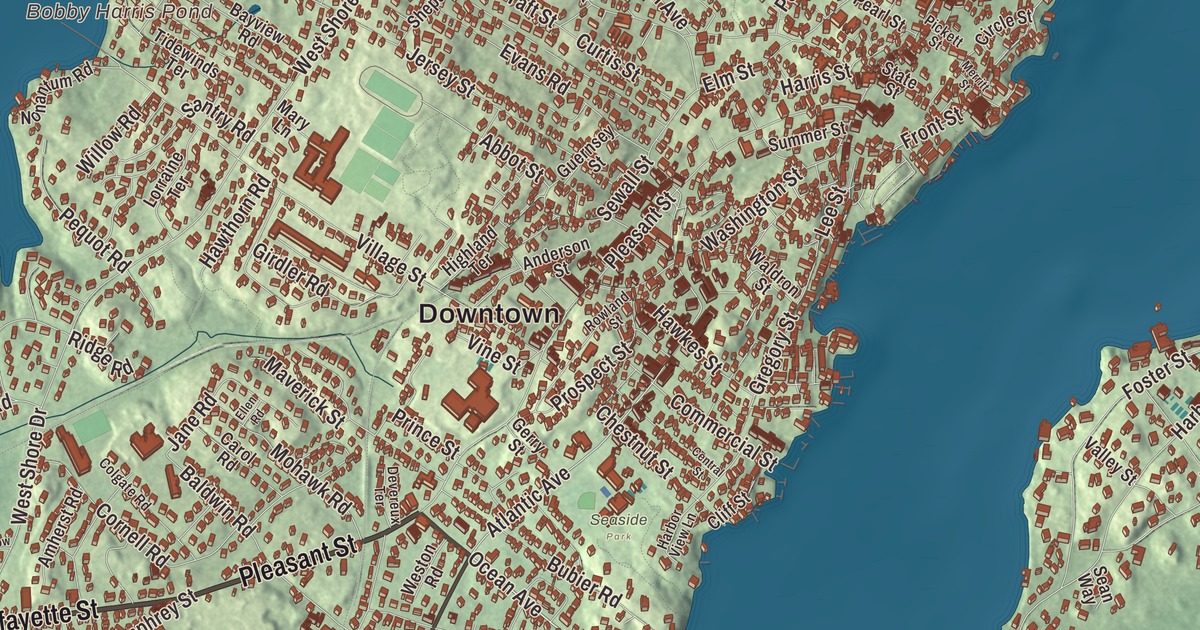
Marblehead is a fishing and sailing town on a small peninsula reaching into Massachusetts Bay, with Marblehead Neck across the harbor and Old Burial Hill on the high ground by the Old Town. This map prints Lafayette Street, Pleasant Street, Atlantic Avenue, Ocean Avenue, Front Street and Abbot Street, with Redds Pond, Black Joe Pond, Ware Pond and Bobby Harris Pond. Click here to purchase a print of this map for your wall.
Marblehead is in Essex County.
KNOWOL made this map in 2026 from public survey data and gave it the look of an old atlas. The relief comes from United States Geological Survey elevation data, and the streets and the town line come from the Census Bureau. Marblehead lies on the North Shore, and Marblehead Neck, a near island, is joined to the mainland by a narrow isthmus. Marblehead Harbor, sheltered from the open sea by shoals and rocks, lies between them. Besides the town center there are two villages, the Old Town, the original center, and Clifton, along the Swampscott line. The town had 20,441 people at the 2020 census.
Ledges that looked like marble
The land was first called Massebequash, after the river between it and Salem, and it was home to the Naumkeag people under the sachem Nanepashemet. In 1684 his heirs sold their 3,700 acres, and the deed is kept today at Abbot Hall. The Town of Marblehead’s recorded history, in the Secretary of the Commonwealth’s list, dates European settlement to 1629, when Joseph Doliber or John Peach (the town page calls it highly disputed) set up on the shore. Three years before that, Isaac Allerton, a Pilgrim from the Mayflower, had started a fishing village at Little Harbor. Captain John Smith called the place Marble Harbour, and the name Marblehead came from settlers who took its granite ledges for marble. The General Court made Marblehead a town in May 1635, on land that belonged to Salem, then reversed itself within a year. Marblehead was incorporated as a town in 1649, and the town remains part of Essex County today.
Marblehead began as a fishing village of narrow, crooked streets that grew inland from the harbor, and much of that Old Town is protected today in the Marblehead Historic District. The district covers 2,300 acres, with 988 contributing buildings and about 200 houses built before the Revolution. Its landmarks include the General John Glover House and the Jeremiah Lee Mansion of 1768, built for Colonel Jeremiah Lee, then the wealthiest merchant and ship owner in the province, and named a National Historic Landmark as one of the finest Late Georgian houses in the country. Fort Sewall, at Gale’s Head on the harbor mouth, was first fortified in 1644. On April 3, 1814, USS Constitution took shelter under its guns from two British frigates, and the fort’s garrison, short of powder, ran out its guns as if to fight, and the British turned away.
Glover’s mariners
Marblehead men went to the Revolution early. The town page says scholars generally recognize the town’s sailors as forerunners of the United States Navy, and the first vessel commissioned for the army, Hannah, sailed with a Marblehead crew and stores that included the local molasses cookie called the Joe Frogger. Marblehead is often called the birthplace of the American Navy, a title Beverly sometimes disputes. Under General John Glover, the Marblehead men helped the Continental Army escape after the Battle of Long Island, and they rowed George Washington across the Delaware River for his attack on Trenton. Their regiment, the 14th Continental, was one of the few integrated regiments in the army. When Washington visited in 1789, he observed that the town “had the appearance of antiquity.” Elbridge Gerry, a signer of the Declaration of Independence and the fifth Vice President, was a native son.
Abbot Hall, on Washington Street, is named for Benjamin Abbot, a barrel maker and trader who left his fortune to the town when he died in 1872. It’s the town hall and a museum, and it holds the original The Spirit of ’76 by Archibald Willard, a bust of Gerry, and a picture of Marbleheaders rowing Washington across the Delaware. Later chapters are proud ones too. The Burgess and Curtis factory here was the first licensed aircraft manufacturer in the United States, and on August 20, 1912, Alfred Austell Cunningham took off from Marblehead Harbor in a Burgess seaplane to become the first Marine aviator, the start of Marine Corps Aviation. The town’s Men’s Softball League, started in 1939, is called the oldest and longest standing adult softball league in the world on the town page, which also names the Pleon Yacht Club as the oldest junior yacht club in America.
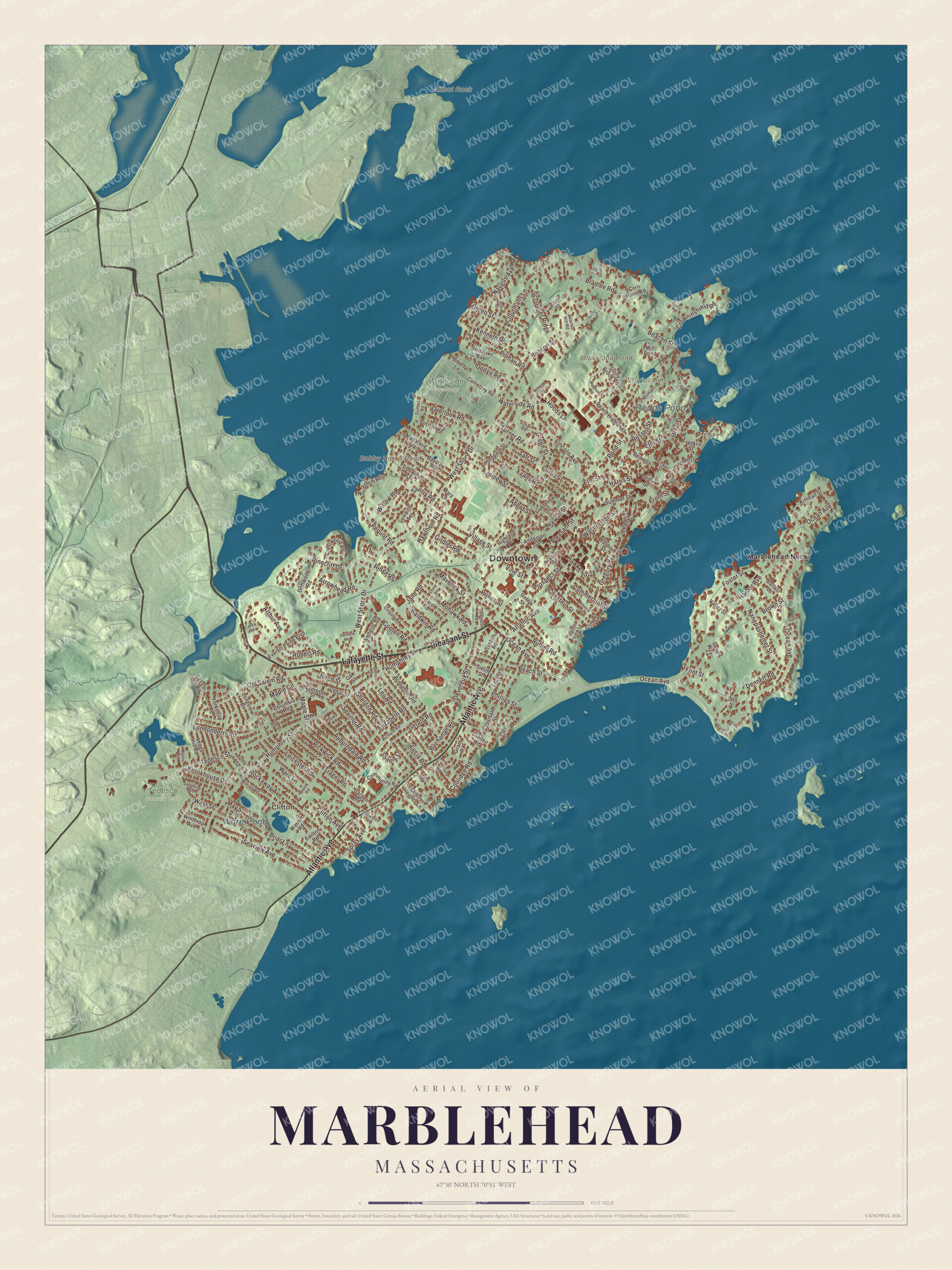
Click to explore a larger preview. The digital watermark does not appear on printed maps.
Names on this map
These names are printed on this map.
Places: Downtown, Clifton, Abbot Rock, Burial Hill, Black Joe Pond, Bobby Harris Pond, Ware Pond, Redds Pond, Seaside Park, Tedesco Country Club, Waterside Cemetery and Marblehead Neck.
Streets and roads: Lafayette Street, Pleasant Street, Atlantic Avenue, Ocean Avenue, Front Street, Abbot Street, Humphrey Street, Russell Street, Leicester Road, Briar Lane, Maple Circle, Santry Road.
More street names, A to Z
Amherst Road, Anderson Street, Arnold Terrace, Arrowhead Road, Arthur Avenue, Auburndale Road, Baldwin Road, Ballast Lane, Bayview Road, Beach Street, Beacon Hill Road, Beacon Street, Birch Street, Blueberry Road, Bradlee Road, Bridge Street, Brookhouse Drive, Brook Road, Broughton Road, Brown Street, Bubier Road, Buchanan Road, Carlton Road, Carna Road, Carol Road, Casino Road, Cedar Street, Cemetery Road, Central Street, Chestnut Street, Circle Street, Cleveland Road, Cliff Street, Clifton Avenue, Clifton Heights Lane, Cloutmans Lane, Colgate Road, Columbia Road, Commercial Street, Community Road, Coolidge Road, Cornell Road, Corn Point Road, Crestwood Road, Crowninshield Road, Curtis Street, Cypress Street, Dean Road, Dennett Road, Devereux Street, Devereux Terrace, Dodge Road, Driftwood Road, Elizabeth Road, Ellen Road, Elm Street, Eustis Road, Evans Road, Everett Paine Boulevard, Flint Street, Foster Street, Franklin Street, Ft Sewall Terrace, Fuller Lane, Garden Road, Gerald Road, Gerry Street, Girdler Road, Grant Road, Green Street, Gregory Street, Guernsey Street, Harbor Avenue, Harbor View Lane, Harris Street, Hawkes Street, Hawthorn Road, Highland Terrace, Hoods Lane, Jane Road, Jersey Street, Johns Road, Kenneth Road, Kimball Street, Laurel Street, Lee Street, Leggs Hill Road, Leo Road, Liberty Lane, Lincoln Avenue, Lindbergh Road, Locust Street, Londonderry Road, Longview Drive, Lorraine Terrace, Lucia Road, Manataug Trail, Maple Street, Marion Road, Mary Lane, Maverick Street, May Street, Merritt Street, Mill Pond, Mohawk Road, Mooring Road, Mystic Road, Nanepashemet Street, Naugus Avenue, Nonantum Road, Norman Street, Oak Street, Old Salem Road, Orchard Street, Orne Street, Overlook Road, Peach Highlands, Pearl Street, Pequot Road, Phillips Street, Pickett Street, Pickwick Road, Pinecliff Drive, Pitman Road, Pond Street, Prince Street, Prospect Street, Puritan Road, Rainbow Road, Richard Road, Ridge Road, Robert Road, Rockaway Avenue, Rolleston Road, Rowland Street, Sandie Lane, Sapphire Avenue, Sargent Road, Schooner Ridge, Sean Way, Seaview Avenue, Sevinor Road, Sewall Street, Sheldon Road, Shepard Street, Smith Street, Spray Avenue, State Street, Stevens Road, Stony Brook Road, Stramski Way, Summer Street, Summit Road, Sunset Road, Susan Road, Taft Street, Tedesco Street, Tidewinds Terrace, Trager Road, Tufts Street, Turner Road, Valley Street, Village Street, Vine Street, Waldron Street, Ware Lane, Warren Road, Washington Street, Waterside Road, Weston Road, West Shore Drive, West Street, Whittier Road, Willow Road, Winthrop Avenue, Yorkshire Road.
Around the map
Start with Clifton, then follow Lafayette Street, Pleasant Street, Atlantic Avenue, Ocean Avenue, Front Street and Abbot Street across town. The Landing, the public town dock, is on Front Street. Then look outward toward Marblehead Neck, where summer homes for wealthy Bostonians went up in the late 1800s. Marblehead Light stands on the Neck; its iron skeleton tower replaced the 1835 tower in 1895, and its page calls it the only tower of its type in New England. Black Joe Pond, Bobby Harris Pond, Ware Pond, Redds Pond and Burial Hill are all printed on the map, and every one of those names is right there on the artwork. Old Burial Hill, the burying ground founded in 1638, was also the site of the town’s First Meeting House, and from its high ground there are views of Marblehead Harbor and Salem Sound; a walkway climbs to it from Redds Pond.
The Marblehead map makes a fine addition to an office, library or den, and it can help teach children the geography and history of a North Shore harbor town. It’s made for people who call Marblehead home, from Clifton to the Neck, and it shows the town as it looks today. Zoom in on the preview above to explore the details, then click here to get your copy of the Marblehead, Massachusetts map.

We made a map for every town and city in Massachusetts. Explore the complete Massachusetts map collection and find your town.
Sources
- Marblehead, Massachusetts, Wikipedia
- Marblehead Historic District, Wikipedia
- Jeremiah Lee Mansion, Wikipedia
- Fort Sewall, Wikipedia
- John Glover (general), Wikipedia
- Elbridge Gerry, Wikipedia
- Abbot Hall (Marblehead, Massachusetts), Wikipedia
- Alfred A. Cunningham, Wikipedia
- Marblehead Light (Massachusetts), Wikipedia
- Old Burial Hill (Marblehead, Massachusetts), Wikipedia
- City and Town Incorporation and Settlement Dates, Secretary of the Commonwealth of Massachusetts (archived copy)