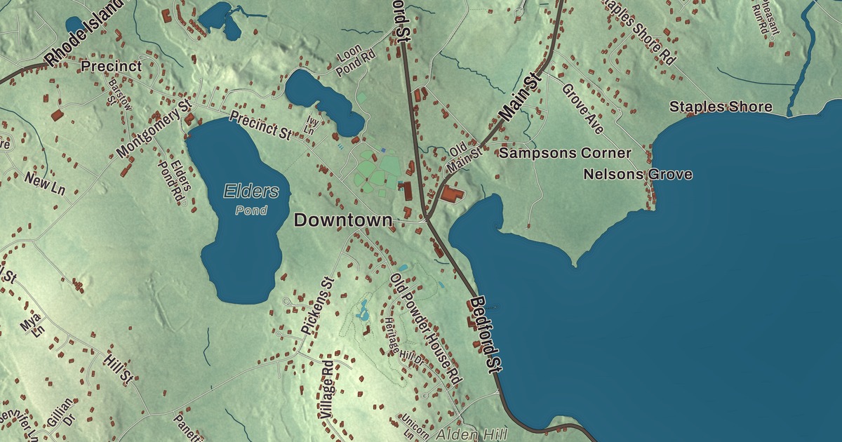
Lakeville is named for its water, and the town page says its namesake lakes dominate its geography. This map prints Bedford Street, Main Street, Myricks Street, Lakeside Avenue, Rhode Island Road and Harding Street, with Assawompset Pond, Long Pond, Cain Pond, Anuxanon Island and Bettys Neck. Click here to purchase a print of this map for your wall.
Lakeville is in Plymouth County.
KNOWOL made this map in 2026 from public survey data and gave it the look of an old atlas. The relief comes from United States Geological Survey elevation data, and the streets and the town line come from the Census Bureau. Lakeville covers 36.1 square miles, 6.6 of them water. It’s roughly at the center of southeastern Massachusetts, about 5 miles north of New Bedford and 40 miles south of Boston, bordered by Middleborough, Rochester, Freetown, Berkley and Taunton. The town had 11,523 people at the 2020 census.
Soewampset and the ponds
The town takes its name from its chain of lakes: Assawompset Pond, Great Quittacas Pond, Little Quittacas Pond, Pocksha Pond and Long Pond, which the town page notes are called “ponds” in everyday speech. The Native name for the area was Soewampset, and a 1634 list of New England settlements names Soewampset as a noted place, which suggests that Assawompset Pond may take its name from a Wampanoag village on its banks. The Wampanoag Royal Cemetery lies on a peninsula between Little and Great Quittacas Pond, and the Wampanoag settlement at Assawompset Pond lasted until at least the early 1800s. During King Philip’s War, Metacomet and his forces sheltered for a time at Assawompset Pond.
A man named Peirce made the first recorded non-native settlement here in 1705. The Town of Lakeville’s recorded history, in the Secretary of the Commonwealth’s list, dates European settlement to 1717, when the area was settled more widely as a western parish of Middleborough. Lakeville was incorporated as a town in 1853, when it split from Middleborough, and the town remains part of Plymouth County today.
Benjamin Simonds and other Lakeville stories
One of Lakeville’s Revolutionary War soldiers was Benjamin Simonds, a Wampanoag man who, according to the town page, served as an aide-de-camp to George Washington at Valley Forge. He likely belonged to one of the town’s two militias, the Pond Militia Company or the Beech Woods Company of Minutemen, which were combined into Middleborough’s Fourth Company of Foot, where he served. He became a local celebrity, both for his service and as the last fully Wampanoag person to live on Assawompset Pond. Ninety-one men from Lakeville served in the Civil War, eighty-five in the army and six in the navy.
Today the cranberry cooperative Ocean Spray has its headquarters in Lakeville; it moved to a building on the Lakeville-Middleborough line in 1989. The Ted Williams Camp, one of the town’s parks, was once the site of a summer baseball camp run by the Boston Red Sox Hall of Famer. The town page counts 31 known cemeteries in Lakeville, almost one for every square mile, drawn from a book of the town’s gravestone inscriptions from 1711 to 2003.
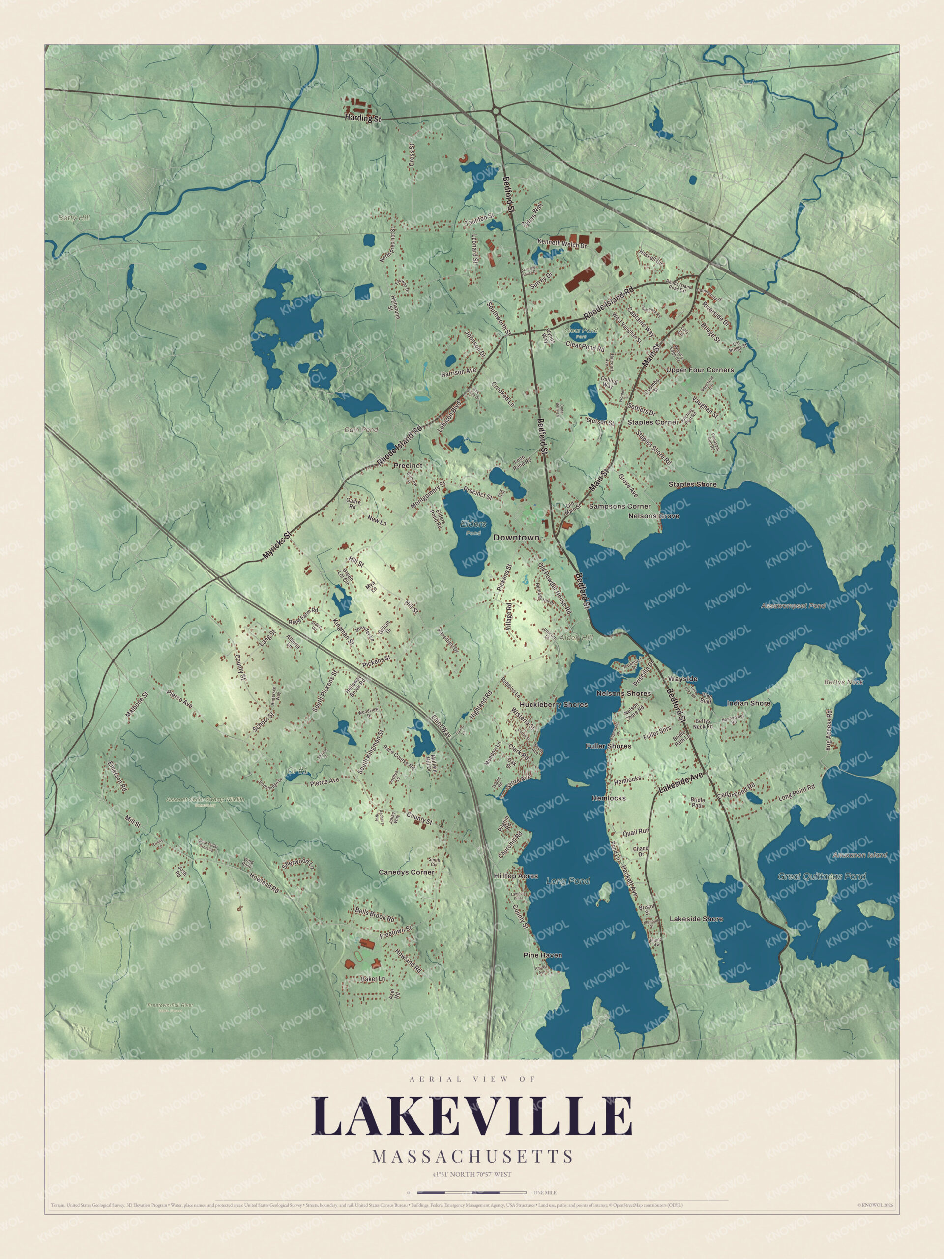
Click to explore a larger preview. The digital watermark does not appear on printed maps.
Names on this map
These names are printed on this map.
Places: Downtown, Alden Hill, Anuxanon Island, Betty Hill, Bettys Neck, Assawompset Pond, Cain Pond, Long Pond, Great Quittacas Pond, Assonet Cedar Swamp Wildlife Sanctuary, Clear Pond Park, Cr #1, Elders Pond, Freetown-Fall River State Forest, Canedys Corner, Fuller Shores, Hemlocks, Hilltop Acres, Huckleberry Shores, Indian Shore, Lakeside Shore, Nelsons Grove, Nelsons Shores, Pine Haven, Precinct, Sampsons Corner, Staples Corner, Staples Shore, Upper Four Corners and Wayside.
Streets and roads: Bedford Street, Main Street, Myricks Street, Lakeside Avenue, Rhode Island Road, Harding Street, Howland Road, Crooked Lane, Staples Shore Road, Vaughan Street, Grove Avenue, County Street.
More street names, A to Z
Alberta Lane, Alden Road, Anderson Way, Andrea Avenue, Azel Road, Baker Lane, Barstow Street, Bells Brook Road, Bettys Neck Road, Bog Access Road, Bridge Street, Bridle Path, Bridle Path Lane, Bristol Street, Captains Way, Carriage House Drive, Carrie Street, Cedar Berry Lane, Cedar Pond Road, Chace Drive, Churchill Road, Clark Road, Clear Pond Road, Commercial Drive, Coombs Street, Cross Street, Deerfield Lane, Edgewater Drive, Elders Pond Road, Elliot Way, Emerson Road, Fairway Drive, Freetown Street, Fuller Shrs, Galfre Road, Gillian Drive, Great Cedar Crossing, Green Lot Circle, Hackett Avenue, Harcourt Avenue, Harrison Avenue, Haskell Circle, Heritage Hill Drive, Highland Road, Highstone Street, Hill Street, Hitching Post Road, Holloway Brook Road, Island Road, Island Vw, Ivy Lane, Jennifer Lane, Johnson Drive, Josh Road, Joshua Lane, Julias Way, Kenneth Welch Drive, Kingman Street, Langlois Pines, Lang Street, Lebaron Boulevard, Leonard Street, Long Point Road, Loon Pond Road, Lori Lane, Malbone Street, Meadow Lane, Mill Street, Montgomery Street, Mullein Hill Drive, Mya Lane, Nachaomet Road, Nelson Shore Road, New Lane, North Precinct Street, Oak Street, Old Bridge Street, Old Main Street, Old Powder House Road, Oshing Way, Panettieri Drive, Parkhurst Drive, Pheasant Run Road, Pickens Street, Pierce Avenue, Pilgrim Road, Pine Bluff, Pine Ridge Drive, Plymouth Street, Pond Lane, Precinct Street, Priscilla Drive, Quail Run, Race Course Road, Rachel's Way, Reed Farm Road, Rhode Island Road Extension, Riverside Drive, Robbins Lane, Rush Pond Road, School Street, Settlers Drive, Shaylee Lane, Sherwood Lane, Shore Avenue, Smith Circle, South Avenue, South Kingman Street, South Pickens Street, Southworth Street, Stetson Street, Stonehedge Drive, Surrey Drive, Susan Lane, Taunton Street, Trinity Lane, Twin Oaks Road, Tylers Way, Unicorn Lane, Village Road, West Vaughan Street, Wind Rush, Wisteria Street, Wood's Edge Road, Woodview Drive, Wordell Lane, Wynns Way.
Around the map
Start with Canedys Corner, then follow Bedford Street, Main Street, Myricks Street, Lakeside Avenue, Rhode Island Road and Harding Street across town. Look outward toward Fuller Shores, Hemlocks, Hilltop Acres, Huckleberry Shores and Indian Shore. Anuxanon Island, Assawompset Pond, Cain Pond, Long Pond, Alden Hill, Betty Hill and Bettys Neck are all printed on the map, and every one of those names is right there on the artwork. Assawompset Pond, shared with Middleborough, covers almost four square miles; its page calls it the largest natural lake in Massachusetts and gives its Wampanoag name as “Place of the White Stones.” Bettys Neck was one of the summer camps of Native people who came up the Taunton and Nemasket rivers to the pond. Assawompset is the source of the Nemasket River, and Long Pond, which Lakeville shares with Freetown, is the source of the Acushnet River. Long Pond is about four miles long and a mile wide, with three islands, Goat, Lewis and Nelson, and the two ponds supply drinking water to New Bedford.
The Lakeville map makes a fine addition to an office, library or den, and it can help teach children the geography and history of a town named for its lakes. It’s made for people who call Lakeville home, from Indian Shore to Canedys Corner, and it shows the town as it looks today. Zoom in on the preview above to explore the details, then click here to get your copy of the Lakeville, Massachusetts map.

We made a map for every town and city in Massachusetts. Explore the complete Massachusetts map collection and find your town.
Sources