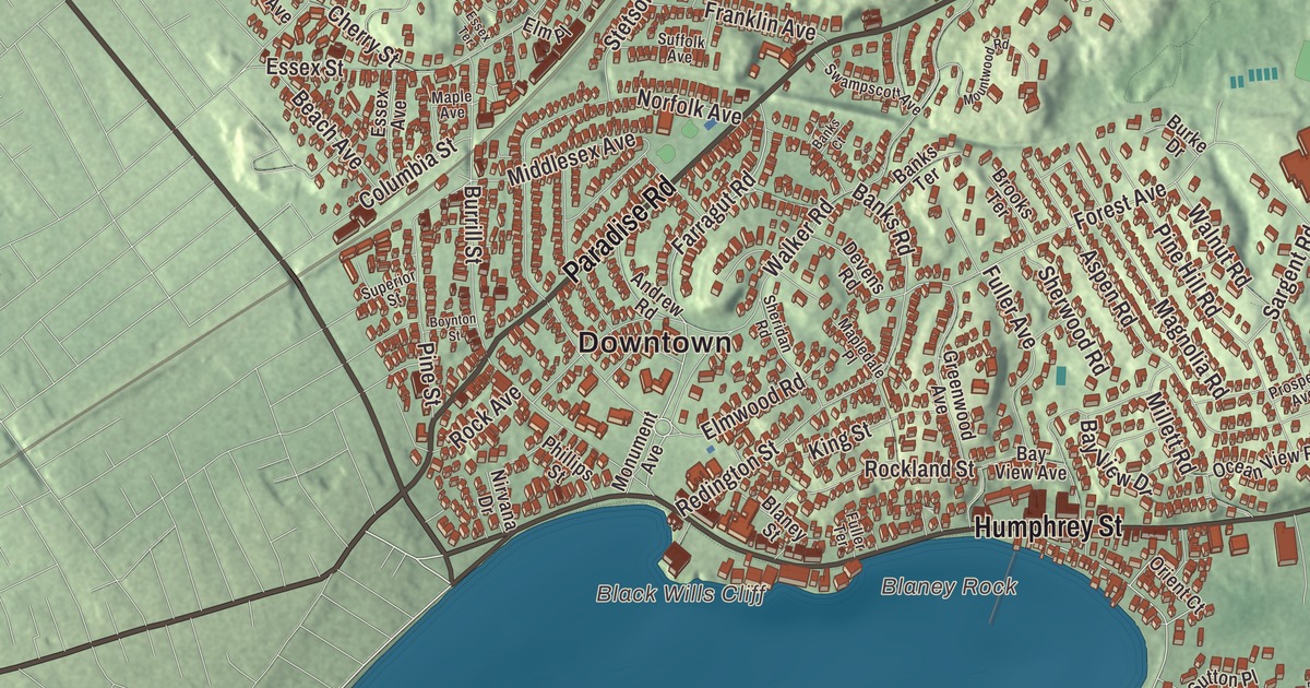
This aerial map of Swampscott, Massachusetts was created in 2026 using real geographic data to bring the town’s streets, buildings, neighborhoods, ponds and waterways, and terrain together in one highly detailed view. Look closer and you can pick out the familiar places that make Swampscott feel like home. Start with the street you know, then see how it connects to the rest of the Swampscott you call home. Click here to purchase a print of this map for your wall.
Explore an aerial view of Swampscott, Massachusetts
Start with Downtown and Beach Bluff. Follow Paradise Road, Humphrey Street, Atlantic Avenue, Puritan Road, Farragut Road, and Middlesex Avenue across town. Then look outward toward Phillips Point.
Foster Pond, Goldfish Pond, Ware Pond, Palmer Pond, Black Wills Cliff, and Blaney Rock are all labeled on the map. Every one of those names is printed directly on the artwork, giving you plenty to explore.
The Town of Swampscott’s recorded history dates European settlement to 1629. Swampscott was incorporated as a town in 1852. The town remains part of Essex County today. Click the image below to see the area as it looked in 2026.
Take a closer look at the Swampscott map
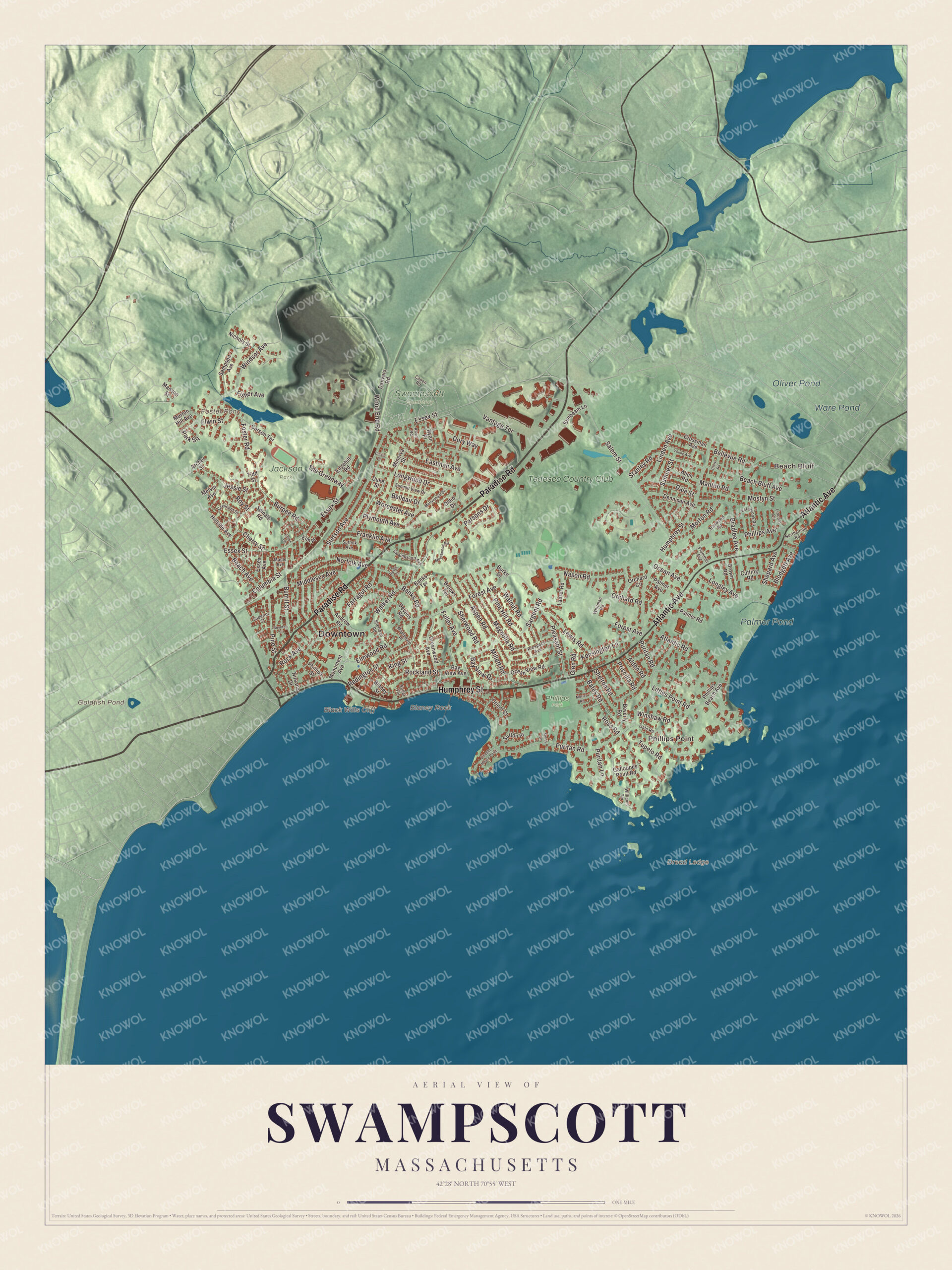
Click to explore a larger preview. The digital watermark does not appear on printed maps.
Names on this map
These names are printed on this map.
Places: Downtown, Beach Bluff, Phillips Point, Black Wills Cliff, Blaney Rock, Dread Ledge, Foster Pond, Goldfish Pond, Ware Pond, Palmer Pond, Oliver Pond, Jackson Park, Phillips Park, Swampscott Cemetery and Tedesco Country Club.
Streets and roads: Paradise Road, Humphrey Street, Atlantic Avenue, Puritan Road, Farragut Road, Middlesex Avenue, Essex Street, Forest Avenue, Salem Street, Windsor Avenue, Burrill Street, Walker Road.
More street names, A to Z
Alden Road, Allen Road, Alvin Road, Andrew Road, Archer Street, Aspen Road, Atlantic Road, Banks Court, Banks Road, Banks Terrace, Bates Road, Bay View Avenue, Bay View Drive, Beach Avenue, Beach Bluff Avenue, Belleair Drive, Bellevue Road, Beverly Road, Blaney Street, Blodgett Avenue, Boynton Street, Bradlee Avenue, Brooks Terrace, Brown Road, Burke Drive, Burpee Road, Capen Road, Carson Terrace, Cherry Street, Clark Road, Columbia Street, Crescent Street, Crossman Avenue, Cutting Road, Dale Street, Danvers Road, Dennison Avenue, Devens Road, Didio Drive, Dilisio Drive, Dory Way, Duke Street, Eastman Avenue, Edgehill Road, Elm Place, Elmwood Road, Elwin Street, Essex Avenue, Essex Terrace, Estabrook Road, Fisher Avenue, Foster Road, Franklin Avenue, Fuller Avenue, Fuller Terrace, Gale Road, Galloupes Point Road, Glen Road, Greenwood Avenue, Hillside Avenue, Jessie Street, Kensington Lane, King Street, Laurel Road, Lewis Road, Lincoln Circle, Lincoln House Point, Linden Avenue, Littles Point Road, Longley Avenue, Longwood Drive, Magnolia Road, Manson Street, Manton Road, Maple Avenue, Mapledale Place, Melvin Avenue, Merrymount Drive, Millett Road, Minerva Street, Monument Avenue, Morton Hill Avenue, Morton Road, Mostyn Street, Mountwood Road, Muriel Road, Nason Road, Nichols Street, Nirvana Drive, Norfolk Avenue, Northstone Road, Ocean Avenue, Ocean View Road, Orchard Circle, Orchard Road, Orient Court, Palmer Avenue, Palmer Road, Park Square, Parsons Drive, Phillips Avenue, Phillips Beach Avenue, Phillips Street, Pine Hill Road, Pine Street, Pleasant Street, Plummer Avenue, Plymouth Avenue, Priscilla Road, Prospect Avenue, Puritan Lane, Redington Street, Rock Avenue, Rockland Street, Ross Road, Roy Street, Ryan Place, Sampson Avenue, Sargent Road, Shelton Road, Shepard Avenue, Sheridan Road, Sherwood Road, Smith Lane, Spinale Road, Stanley Road, Stanwood Road, Stetson Avenue, Suffolk Avenue, Summit View Drive, Sumner Street, Sunbeam Lane, Superior Street, Sutton Place, Swampscott Avenue, The Greenway, Tidd Street, Tupelo Road, Vantage Terrace, Walnut Road, Whitman Road, Williams Terrace, Winshaw Road, Wood End Road, Worcester Avenue, Young Avenue.
See it on a wall
The Swampscott map as a framed print. Swipe for more.


We designed the artwork at KNOWOL using Swampscott’s real streets, buildings, neighborhoods, ponds and waterways, and terrain, the town boundary, and the way buildings spread across the town. Then we chose the color, relief, lettering, and layout that make the map look great on the wall.
This beautifully detailed map of Swampscott makes an attractive addition to your office, library, or den and can even be used to teach children the geography and history of the area. When you’re done exploring, click here to get your copy of the Swampscott, Massachusetts map.