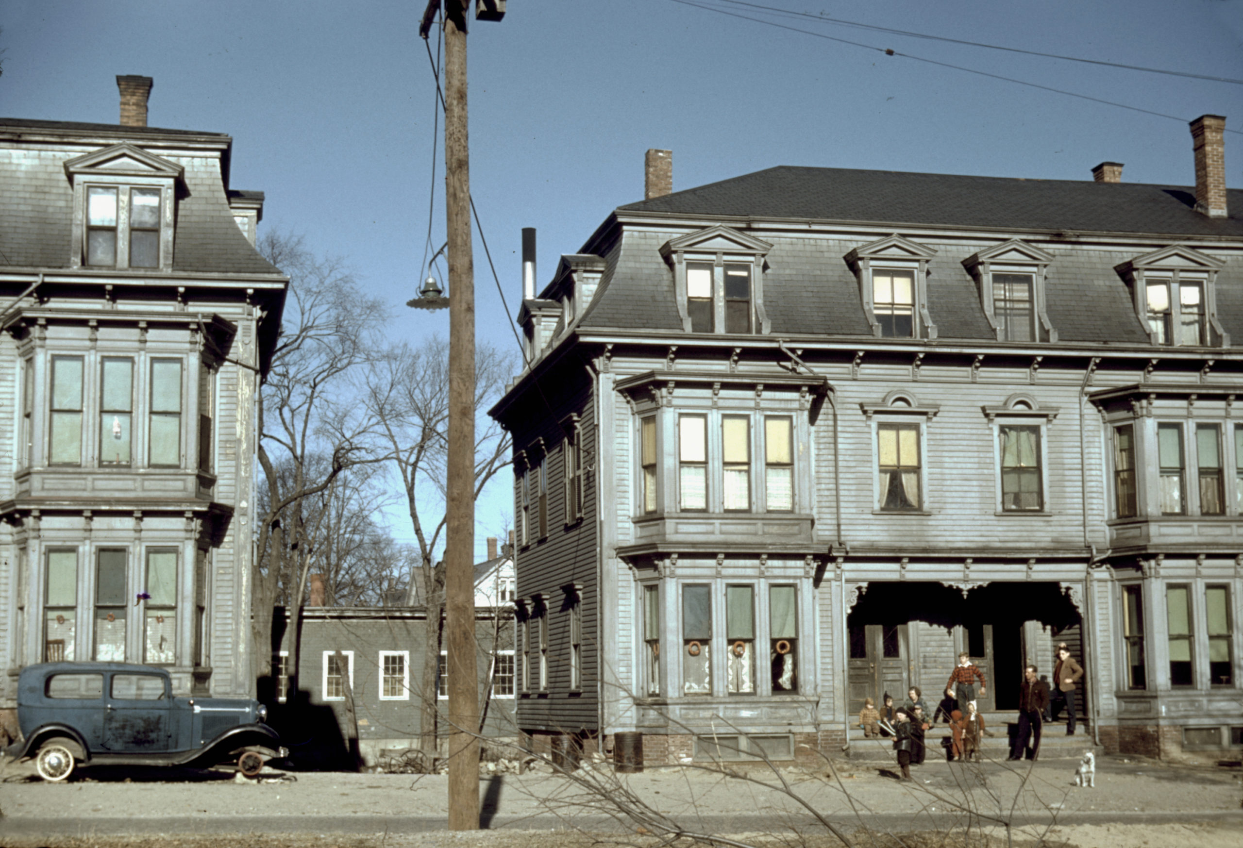
This photo showing children in the tenement district of Brockton, MA was taken by Jack Delano in December, 1940. The building on the left is 14-20 Rosseter St and the one on the right is 22-28 Rosseter St.
More Pictures of Massachusetts
Beautifully detailed map of Winchendon, MA from 1878
Historic bird’s eye view of Winchendon, Massachusetts from 1878
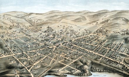
Beautifully detailed map of Hyde Park, Massachusetts from 1879
Historic bird’s eye view of Hyde Park, Massachusetts in 1879
Beautiful old map of Waltham, Massachusetts from 1877
Detailed bird’s eye view of Waltham, Massachusetts in 1877
Beautifully restored map of Westford, MA from 1886
Historic bird’s eye view of Westford, Massachusetts from 1886
Beautiful map of Onset Bay Grove in Wareham, MA from 1885
Click here to see what Wareham, Massachusetts looked like in the late 19th century.
Beautifully detailed map of East Douglas, Mass from 1886
Click here to see the full map.
Beautifully detailed map of Whitinsville, Massachusetts from 1879
Detailed bird’s eye view of Whitinsville, Massachusetts in 1879
The Gloucester, Massachusetts sea serpent sightings of 1817
In August 1817, it was reported by various authorities that an animal with a unique appearance had been recently and repeatedly seen in the harbor of Gloucester, Cape Ann Massachusetts. It was said to resemble a serpent in its general form and motions, to be of immense size, and to move with wonderful speed.
Amazingly detailed map of Taunton, MA from 1875
This map shows Taunton, Mass as it looked in 1875
Beautifully restored map of Uxbridge, Massachusetts from 1880
Detailed bird’s eye view of Uxbridge, Massachusetts in 1880
Beautifully detailed map of Medway, Massachusetts from 1887
Bird’s eye view of Medway, Massachusetts from 1887
Bird’s eye view of Williamstown, Massachusetts in 1889
Click here to see Williamstown, MA in 1889
Bird’s Eye View of North Adams, Massachusetts in 1881
Historic bird’s eye view of North Adams, Massachusetts from 1881
Historic map of Middleboro, MA from 1881
Detailed bird’s eye view of Middleboro, Massachusetts from 1881
Historical map of New Bedford, Massachusetts from 1871
This amazing map of New Bedford, Massachusetts shows the town as it looked in 1871
Historic old map of Winchester, MA from 1886
Detailed bird’s eye view of Winchester, Massachusetts from 1886
Wonderfully detailed map of East Bridgewater, MA from 1887
This map shows East Bridgewater, Massachusetts as it looked in 1887.
Beautifully Detailed Map of Barre, MA from 1891
Step back in time to 1891 Barre, Massachusetts, with this captivating bird’s-eye view map. Discover the town’s booming granite industry, iconic landmarks, and bustling community life. Explore historical details, from factories and railroads to cemeteries and public squares. Own a piece of Barre’s history and uncover the fascinating story of this once-thriving town.