South Dakota Town Maps A to Z
All 497 town maps, from Aberdeen to Yankton. Each one opens its own page with the whole map.
A
B
- Badger
- Baltic
- Bancroft
- Batesland
- Bath
- Bath Corner
- Belle Fourche
- Belvidere
- Beresford
- Big Stone City
- Bijou Hills
- Bison
- Blackhawk
- Blucksberg Mountain
- Blumengard Colony
- Blunt
- Bon Homme Colony
- Bonesteel
- Boulder Canyon
- Bowdle
- Box Elder
- Bradley
- Brandon
- Brandt
- Brant Lake
- Brant Lake South
- Brentford
- Brentwood Colony
- Bridger
- Bridgewater
- Bristol
- Britton
- Broadland
- Brookings
- Bruce
- Bryant
- Buffalo
- Buffalo Chip
- Buffalo Gap
- Bullhead
- Burbank
- Burke
- Bushnell
- Butler
C
- Cameron Colony
- Camp Crook
- Camrose Colony
- Canistota
- Canova
- Canton
- Caputa
- Carthage
- Castlewood
- Cavour
- Cedar Grove Colony
- Centerville
- Central City
- Chamberlain
- Chancellor
- Chelsea
- Cherry Creek
- Chester
- Claire City
- Claremont
- Claremont Colony
- Clark
- Clark Colony
- Clear Lake
- Clearfield Colony
- Cloverleaf Colony
- Collins Colony
- Colman
- Colome
- Colonial Pine Hills
- Colton
- Columbia
- Conde
- Corn Creek
- Corona
- Corsica
- Cottonwood
- Cow Creek
- Cresbard
- Crocker
- Crook City
- Crooks
- Custer
D
E
F
G
H
I
J
K
L
M
- Madison
- Manderson-White Horse Creek
- Mansfield
- Marion
- Martin
- Marty
- Marvin
- Maurine
- Maverick Junction
- Maxwell Colony
- Mayfield Colony
- McIntosh
- McLaughlin
- Meadow View Addition
- Meckling
- Mellette
- Menno
- Midland
- Milbank
- Milesville
- Millbrook Colony
- Miller
- Millerdale Colony
- Milltown
- Mina
- Mission
- Mission Hill
- Mitchell
- Mobridge
- Monroe
- Montrose
- Morningside
- Morristown
- Mound City
- Mount Vernon
- Mountain Plains
- Murdo
N
O
P
Q
R
S
- Salem
- Scotland
- Selby
- Seneca
- Shamrock Colony
- Shannon Colony
- Sherman
- Shindler
- Sicangu Village
- Silver Lake Colony
- Sinai
- Sioux Falls
- Sisseton
- Smithwick
- Soldier Creek
- South Shore
- Spearfish
- Spencer
- Spink Colony
- Spring Creek
- Spring Creek Colony
- Spring Lake Colony
- Spring Valley Colony
- Springfield
- St. Charles
- St. Francis
- St. Lawrence
- St. Onge
- Stephan
- Stickney
- Stockholm
- Storla
- Strandburg
- Stratford
- Sturgis
- Summerset
- Summit
- Sunset Colony
- Swift Bird
T
U
V
W
- Wagner
- Wakonda
- Wakpala
- Wall
- Wallace
- Wanblee
- Ward
- Warner
- Wasta
- Watertown
- Waubay
- Waverly
- Webster
- Wentworth
- Wessington
- Wessington Springs
- West Brule
- Westport
- Westwood Colony
- Wetonka
- White
- White Horse
- White Lake
- White River
- White Rock
- White Rock Colony
- Whitehorse
- Whitewood
- Willow Lake
- Wilmot
- Winfred
- Winner
- Wolf Creek Colony
- Wolsey
- Wonderland Homes
- Wood
- Woonsocket
- Worthing
- Wounded Knee
Y
Don’t see your town? Ask us to draw it.
About South Dakota
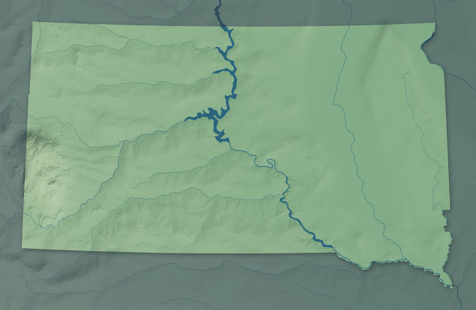
The Missouri River cuts South Dakota in two, and people here still split the state into East River and West River. East River is mostly farm country, and West River is mostly ranch land, with the Badlands and the Black Hills. Pierre won the vote to be the capital at statehood in 1889, then had to win it again in 1890 and 1904.
Sioux Falls and Rapid City are the biggest cities. Many East River towns began as railroad stops in the Dakota Boom of the 1880s, while Deadwood, Lead and Rapid City began with the gold rush of 1876. Nine tribal nations of the Lakota, Dakota and Nakota people have reservations in South Dakota.
- Statehood
- November 2, 1889
- Capital
- Pierre
- Population
- 935,0942025 Census estimate
- Highest point
- Black Elk Peak, 7,244 feet
- Lowest point
- Big Stone Lake on the Minnesota border, 966 feet
- Size
- 77,116 square miles, the 17th largest state
The Black Hills
Rapid City, Spearfish, Sturgis and Hot Springs sit around the Black Hills, which the Lakota call Paha Sapa, hills that look black under their pine forests. Deadwood began as a gold camp in 1876, and the whole town is now a National Historic Landmark. Near Keystone, workers carved Mount Rushmore from 1927 to 1941. In Lead, the Homestake Mine dug gold from 1876 until 2002 and went more than 8,000 feet underground.


The Badlands and West River
Ranch towns like Philip, Kadoka, Murdo, Winner and Lemmon sit far apart on the West River plains. Philip is named for Scotty Philip, a rancher who helped save the bison. Near Interior, the Badlands rise in layered buttes and spires, and the park's South Unit is on the Pine Ridge Reservation of the Oglala Sioux Tribe. The Rosebud Sioux Tribe is based at Rosebud and the Cheyenne River Sioux Tribe at Eagle Butte, and the Standing Rock Sioux Tribe's land crosses the North Dakota line.


Pierre and the Missouri River
Pierre and Fort Pierre face each other across the Missouri, and Mobridge and Chamberlain are river towns too. In 1913, schoolchildren on a hill above Fort Pierre found a lead plate that French explorers had buried in 1743. On the bluffs near Chamberlain, a 50-foot steel statue called Dignity shows a Lakota woman with a star quilt around her shoulders. The Crow Creek, Lower Brule and Yankton Sioux tribes have their lands along this stretch of the river.


Aberdeen and the James River Valley
The James River, which people here call the Jim, runs south through the farm country around Aberdeen, Redfield and Huron. Aberdeen began in 1881 on the Milwaukee Road, and it's called the Hub City because four railroads met there. L. Frank Baum ran a store and a newspaper in Aberdeen from 1888 to 1891, before he wrote The Wonderful Wizard of Oz. In Wessington Springs, a teacher named Emma Shay planted a Shakespeare garden in 1927.


Watertown and the Glacial Lakes
Glaciers left the lakes that dot the northeast around Watertown, Webster, Clear Lake and Milbank. Laura Ingalls Wilder's family came to De Smet in 1879, and five of her books are set there, including Little Town on the Prairie. Brookings is home to South Dakota State University, founded in 1881. The Sisseton Wahpeton Oyate are based at Agency Village near Sisseton, and the Flandreau Santee Sioux Tribe is based at Flandreau.


Sioux Falls and the Southeast
Sioux Falls, the state's largest city, grew up around the falls of the Big Sioux River, and its old courthouse is built of pink Sioux quartzite. Yankton was the first capital of Dakota Territory, from 1861 to 1883. In Mitchell, the Corn Palace gets a new design made of corn and other grains every year. Bon Homme Colony, founded in 1874, is the oldest Hutterite colony still in existence.


- 12 × 18 inPrint $39.99Framed $89.99
- 18 × 24 inPrint $49.99Framed $129.99
- 24 × 36 inPrint $89.99Framed $199.99

Sizes and Prices
Every map comes in three sizes on archival matte paper. Framed prints come in black or white wood.
How each map is made
It starts with the real place
Streets, buildings, terrain and water form the map, drawn the way South Dakota looks today.
Then the details
Local research and an old atlas style give each town its character.
Then it's yours
Look around the map, then pick a print to keep or give.