Tennessee Town Maps A to Z
All 641 town maps, from Adams to Yuma. Each one opens its own page with the whole map.
A
B
- Baileyton
- Ball Camp
- Baneberry
- Banner Hill
- Barfield
- Bargerton
- Bartlett
- Baxter
- Bean Station
- Beech Bluff
- Beersheba Springs
- Bell Buckle
- Belle Meade
- Bellevue
- Bells
- Belvidere
- Benton
- Berry Hill
- Bethel Springs
- Bethesda
- Bethpage
- Big Rock
- Big Sandy
- Biltmore
- Blackman
- Blaine
- Blanche
- Bloomingdale
- Blountville
- Bluff City
- Bogota
- Bolivar
- Bolton
- Bon Air
- Bon Aqua Junction
- Bonny Kate
- Boone
- Boone Lake
- Bowman
- Boyds Creek
- Braden
- Bradford
- Bransford
- Brentwood
- Briceville
- Bridgeport
- Brighton
- Bristol
- Broadview
- Brownsville
- Bruceton
- Buchanan
- Bulls Gap
- Burlison
- Burns
- Butler
- Byrdstown
C
- Calhoun
- Camden
- Camp Creek
- Carter, Carter County
- Carter, Knox County
- Carthage
- Caryville
- Cassville
- Castalian Springs
- Cedar Bluff
- Cedar Hill
- Celina
- Center Hill Lake
- Centertown
- Centerville
- Central
- Chapel Hill
- Charleston
- Charlotte
- Chattanooga
- Cherokee
- Cherokee Lake
- Chesterfield
- Chewalla
- Childers Hill
- Chilhowee Lake
- Christiana
- Chuckey
- Church Hill
- Clairfield
- Clarkrange
- Clarksburg
- Clarksville
- Claxton
- Cleveland
- Clifton
- Clinton
- Clovercroft
- Coalfield
- Coalmont
- Coker Creek
- College Grove
- Collegedale
- Collierville
- Collinwood
- Colonial Heights
- Colonial Village
- Columbia
- Conasauga
- Cookeville
- Cooper-Young
- Coopertown
- Copperhill
- Cordell Hull Lake
- Cornersville
- Corryton
- Cosby
- Cottage Grove
- Cottontown
- Counce
- Covington
- Cowan
- Crab Orchard
- Cross Plains
- Crossville
- Crump
- Culleoka
- Cumberland City
- Cumberland Gap
- Cumberland Heights
D
E
F
G
- Gadsden
- Gainesboro
- Gallatin
- Gallaway
- Garland
- Gates
- Gatlinburg
- Germantown
- Gibson
- Gilt Edge
- Gladeville
- Gleason
- Goodlettsville
- Gordonsville
- Graball
- Grand Junction
- Grassland
- Grassy Fork
- Gray
- Graysville
- Great Smoky Mountains National Park
- Green Hill
- Greenback
- Greenbrier
- Greeneville
- Greenfield
- Greenvale
- Griffith Creek
- Grimsley
- Gruetli-Laager
- Guys
H
- Habersham
- Halls
- Halls Crossroads
- Hampshire
- Hampton
- Harriman
- Harrison
- Harrogate
- Hartsville
- Helenwood
- Henderson
- Hendersonville
- Henning
- Henry
- Hermitage Springs
- Hickman
- Hickory Hill
- Hickory Valley
- Highland Park
- Highland Park, Chattanooga
- Hilham
- Hillsboro
- Hohenwald
- Holladay
- Hollow Rock
- Holston
- Holston Hills
- Holston View
- Homestead
- Hopewell
- Hornbeak
- Hornsby
- Humboldt
- Hunter
- Huntingdon
- Huntland
- Huntsville
- Huron
I
J
K
L
- La Follette
- La Grange
- La Vergne
- Lafayette
- Lake Tansi
- Lakeland
- Lakesite
- Lakewood Park
- Lanier
- Lascassas
- Lavinia
- Lawrenceburg
- Lebanon
- Lenoir City
- Lenox
- Leoma
- Lewisburg
- Lexington
- Liberty
- Lincoln
- Linden
- Little Milligan
- Livingston
- Lobelville
- Lone Oak
- Lookout Mountain
- Loretto
- Loudon
- Louisville
- Luray
- Luttrell
- Lyles
- Lynchburg, Moore County
- Lynnville
M
- Madison
- Madisonville
- Manchester
- Marguerite
- Martin
- Maryville
- Mascot
- Mason
- Maury City
- Mayland
- Maynardville
- McDonald
- McEwen
- McKenzie
- McLemoresville
- McMinnville
- Medina
- Medon
- Melton Hill Lake
- Memphis
- Mercer
- Michie
- Middle Valley
- Middleton
- Midtown
- Midtown, Memphis
- Midway
- Milan
- Milledgeville
- Millersville
- Millington
- Minor Hill
- Miston
- Mitchellville
- Monteagle
- Monterey
- Montvale
- Mooresburg
- Morris Chapel
- Morrison
- Morristown
- Moscow
- Mosheim
- Mount Carmel
- Mount Horeb
- Mount Juliet
- Mount Pleasant
- Mountain City
- Mowbray Mountain
- Munford
- Murfreesboro
N
O
P
- Palmer
- Palmersville
- Paris
- Park City
- Parker's Crossroads
- Parkridge
- Parkway Village
- Parrottsville
- Parsons
- Paulette
- Pegram
- Pelham
- Percy Priest Lake
- Petersburg
- Petros
- Philadelphia
- Piedmont
- Pigeon Forge
- Pikeville
- Pine Crest
- Pine Haven
- Pinson
- Piperton
- Pisgah
- Pittman Center
- Plainview
- Plainview, Rutherford County
- Pleasant Hill
- Pleasant View
- Pocahontas
- Portland
- Powell
- Powell Valley
- Powells Crossroads
- Prospect
- Prospect, Blount County
- Prospect, Bradley County
- Pulaski
- Puryear
R
S
- Sale Creek
- Salem
- Saltillo
- Samburg
- Sango
- Santa Fe
- Sardis
- Saulsbury
- Savannah
- Scotts Hill
- Selmer
- Sequatchie
- Sevierville
- Sewanee
- Seymour
- Shackle Island
- Sharon
- Sharps Chapel
- Shelbyville
- Sherwood
- Shiloh
- Signal Mountain
- Silerton
- Slayden
- Smithville
- Smyrna
- Sneedville
- Snow Hill
- Soddy-Daisy
- Somerville
- South Carthage
- South Cleveland
- South Fulton
- South Holston Lake
- South Memphis
- South Pittsburg
- Southside
- Sparta
- Spencer
- Spring City
- Spring Hill
- Spring Hill, Gibson County
- Springdale
- Springfield
- Spurgeon
- St. Joseph
- Stanton
- Stantonville
- Statesville
- Strawberry Plains
- Sullivan Gardens
- Sulphur Springs
- Summertown
- Sunbright
- Surgoinsville
- Sweetwater
- Sycamore
T
U
V
W
- Walden
- Walland
- Walnut Grove, Hardin County
- Walnut Grove, Sumner County
- Walnut Hill
- Walterhill
- Wartburg
- Wartrace
- Washburn
- Watauga
- Watauga Lake
- Watertown
- Watts Bar Reservoir
- Waverly
- Waynesboro
- West Hills
- Westmoreland
- Westpoint
- White Bluff
- White House
- White Oak
- White Pine
- Whitehaven
- Whitesburg
- Whiteside
- Whiteville
- Whitlock
- Whitwell
- Wildersville
- Wildwood
- Wildwood Lake
- Williston
- Winchester
- Winfield
- Woodbury
- Woodland Mills
- Woodlawn
- Woodstock
- Wrigley
- Wynn
- Wynnburg
Y
Don’t see your town? Ask us to draw it.
About Tennessee
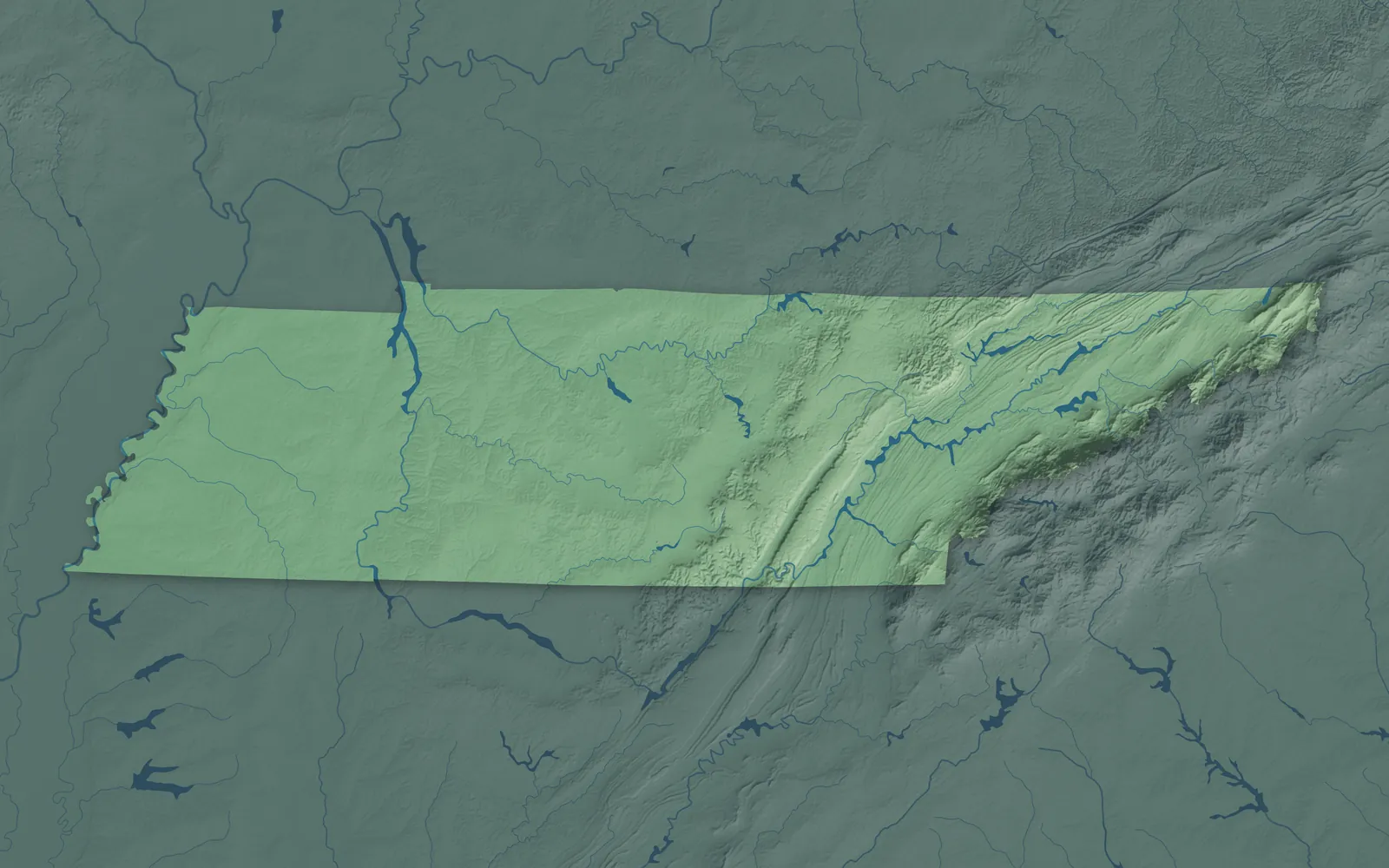
Tennessee is long and narrow, about 440 miles from the Appalachian Mountains on its eastern edge to the Mississippi River. By law it has three Grand Divisions: the ridges and valleys of East Tennessee, the rolling hills of Middle Tennessee, and the flat farmland of West Tennessee. The three stars on the state flag stand for them. Tennessee became the 16th state in 1796, the first one made from a federal territory.
Nashville, Memphis, Knoxville, Chattanooga and Clarksville are the biggest cities. Many smaller towns began as river landings, railroad stops, coal and mill towns, or county seats built around a courthouse square. Tennessee is called the Volunteer State for the thousands of its people who volunteered to fight in the War of 1812.
- Statehood
- June 1, 1796
- Capital
- Nashville
- Population
- 7,315,0762025 Census estimate
- Highest point
- Kuwohi (formerly Clingmans Dome), 6,643 feet
- Lowest point
- Mississippi River at the Mississippi border, 178 feet
- Size
- 42,144 square miles, the 36th largest state
Memphis and West Tennessee
Memphis sits on bluffs above the Mississippi River in the southwest corner. The flat farm country of West Tennessee spreads east to the Tennessee River, around Jackson, Dyersburg, Union City, Martin and Paris. In 1977, Congress named Beale Street in Memphis the Home of the Blues, and Elvis Presley recorded his first single at Sun Studio there in 1954. In the northwest corner, Reelfoot Lake is known for its cypress trees and the bald eagles that winter there.


Nashville and Middle Tennessee
Nashville sits on the Cumberland River in rolling hill and farm country, with Murfreesboro, Franklin, Clarksville, Columbia, Lebanon and Tullahoma around it. Nashville began in 1779 as Fort Nashborough, and the Grand Ole Opry has been on the radio there since 1925. Columbia's Mule Day began in 1840 as a meeting day for mule breeders. Lynchburg is home to the Jack Daniel's distillery.


The Upper Cumberland
The Upper Cumberland is the hill and plateau country east of Nashville, with Cookeville, Crossville, McMinnville, Sparta, Smithville and Livingston. Dale Hollow and Center Hill lakes spread through its river valleys. McMinnville is known as the Nursery Capital of the World. In the 1930s, the government built the Cumberland Homesteads near Crossville, houses of local sandstone for struggling families. Near Pall Mall, the farm and gristmill of Alvin York, a hero of World War I, are now a state park.


Chattanooga and Southeast Tennessee
Chattanooga sits on a bend of the Tennessee River below Lookout Mountain, with Cleveland, Athens, Dayton, Dunlap and Jasper nearby. The Incline Railway has climbed Lookout Mountain since 1895, and it's one of the steepest passenger railways in the world. In 1925, the Scopes trial over teaching evolution was held in the Rhea County Courthouse in Dayton, which is still in use. The whitewater races of the 1996 Olympics were held on the Ocoee River.


Knoxville, Oak Ridge and Morristown
Knoxville sits where the Holston and French Broad rivers meet to form the Tennessee River, with Oak Ridge, Morristown, Lenoir City, Clinton and Oneida around it. Knoxville was Tennessee's first capital. Oak Ridge was built in secret starting in 1942 for the Manhattan Project, and it's still called the Secret City. Up on the Cumberland Plateau, English author Thomas Hughes founded the village of Rugby in 1880, and many of its Victorian buildings still stand.


The Great Smoky Mountains
The Great Smoky Mountains rise along the North Carolina line above Gatlinburg, Pigeon Forge, Sevierville, Townsend, Maryville and Newport. The national park here is the most visited in the country. In Cades Cove, near Townsend, the log cabins, churches and gristmill of an old mountain farm valley still stand. Dolly Parton grew up in the hills of Sevier County, and Dollywood opened in Pigeon Forge in 1986.


The Tri-Cities and Northeast Tennessee
Kingsport, Johnson City and Bristol make up the Tri-Cities, in the mountains and valleys of the northeast corner. Greeneville, Elizabethton, Rogersville, Erwin and Mountain City are nearby. Founded in 1779, Jonesborough is the oldest town in Tennessee, and it has held the National Storytelling Festival since 1973. In 1927, the Carter Family and Jimmie Rodgers made their first records in Bristol, where State Street is the state line.


- 12 × 18 inPrint $39.99Framed $89.99
- 18 × 24 inPrint $49.99Framed $129.99
- 24 × 36 inPrint $89.99Framed $199.99

Sizes and Prices
Every map comes in three sizes on archival matte paper. Framed prints come in black or white wood.
How each map is made
It starts with the real place
Streets, buildings, terrain and water form the map, drawn the way Tennessee looks today.
Then the details
Local research and an old atlas style give each town its character.
Then it's yours
Look around the map, then pick a print to keep or give.