Oklahoma Town Maps A to Z
All 887 town maps, from Achille to Zion. Each one opens its own page with the whole map.
A
B
- Bache
- Badger Lee
- Baker
- Balko
- Ballou
- Banner
- Barber
- Barnsdall
- Baron
- Bartlesville
- Battiest
- Bearden
- Beaver
- Bee
- Beggs
- Belfonte
- Bell
- Bennington
- Bentley
- Bernice
- Bessie
- Bethany
- Bethel Acres
- Big Cabin
- Billings
- Binger
- Bison
- Bixby
- Blackburn
- Blackgum
- Blackwell
- Blair
- Blanchard
- Blanco
- Blue
- Bluejacket
- Boise City
- Bokchito
- Bokoshe
- Boley
- Boswell
- Bowden
- Bowlegs
- Bowring
- Box
- Boynton
- Bradley
- Braggs
- Braman
- Bray
- Breckenridge
- Brent
- Briartown
- Bridge Creek
- Bridgeport
- Briggs
- Bristow
- Broken Arrow
- Broken Bow
- Broken Bow Lake
- Bromide
- Brooksville
- Brush Creek
- Brushy
- Bryant
- Buffalo
- Bug Tussle
- Bull Hollow
- Bunch
- Burbank
- Burlington
- Burneyville
- Burns Flat
- Bushyhead
- Butler
- Byars
- Byng
- Byron
C
- Cache
- Caddo
- Calera
- Calumet
- Calvin
- Camargo
- Cameron
- Canadian
- Canadian Shores
- Caney
- Caney Ridge
- Canton
- Canton Lake
- Canute
- Capron
- Carlisle
- Carlton Landing
- Carmen
- Carnegie
- Carney
- Carrier
- Carter
- Cartwright
- Cashion
- Castle
- Catoosa
- Cave Spring
- Cayuga
- Cedar Crest
- Cedar Lake
- Cedar Valley
- Cement
- Centrahoma
- Central High
- Chambers
- Chance
- Chandler
- Chattanooga
- Checotah
- Chelsea
- Cherokee
- Cherry Tree
- Chester
- Chewey
- Cheyenne
- Chickasha
- Choctaw
- Chouteau
- Christie
- Cimarron City
- Claremore
- Clarita
- Clarksville
- Clayton
- Clearview
- Cleo Springs
- Cleora
- Cleveland
- Clinton
- Cloud Creek
- Coalgate
- Colbert
- Colcord
- Cole
- Coleman
- Collinsville
- Colony
- Comanche
- Commerce
- Connerville
- Cookson
- Cooperton
- Copan
- Copeland
- Corn
- Cornish
- Cottonwood
- Council Hill
- Covington
- Coweta
- Cowlington
- Coyle
- Crescent
- Crescent Springs
- Cromwell
- Crowder
- Cumberland
- Cushing
- Custer City
- Cyril
D
E
F
G
- Gage
- Gans
- Garber
- Garvin
- Gate
- Geary
- Gene Autry
- Geronimo
- Gerty
- Gideon
- Glencoe
- Glenpool
- Glover
- Golden
- Goldsby
- Goltry
- Goodwell
- Gore
- Gotebo
- Gould
- Gowen
- Gracemont
- Grainola
- Grand Lake O' the Cherokees
- Grand Lake Towne
- Grandfield
- Grandview
- Granite
- Grant
- Grayson
- Greasy
- Great Salt Plains Lake
- Greenfield
- Greenville
- Gregory
- Grove
- Guthrie
- Guymon
- Gypsy
H
- Haileyville
- Hallett
- Hammon
- Hanna
- Hanson
- Hardesty
- Harrah
- Hartshorne
- Haskell
- Hastings
- Haworth
- Haywood
- Headrick
- Healdton
- Heavener
- Helena
- Hendrix
- Hennepin
- Hennessey
- Henryetta
- Hickory
- Hillsdale
- Hinton
- Hitchcock
- Hitchita
- Hobart
- Hochatown
- Hodgen
- Hoffman
- Holdenville
- Hollis
- Hollister
- Holly Creek
- Homer
- Homestead
- Hominy
- Honey Hill
- Hooker
- Hoot Owl
- Hopeton
- Horntown
- Hough
- Howe
- Hoyt
- Hugo
- Hulbert
- Hunter
- Hydro
I
J
K
L
- Lahoma
- Lake Altus
- Lake Aluma
- Lake Ellsworth Addition
- Lake Eufaula
- Lake Hefner
- Lake Lawtonka
- Lake of the Arbuckles
- Lake Overholser
- Lake Stanley Draper
- Lake Texoma
- Lake Thunderbird
- Lakeside Village
- Lamar
- Lambert
- Lamont
- Lane
- Langley
- Langston
- Latta
- Laverne
- Lawrence Creek
- Lawton
- Lawtonka Acres
- Le Flore
- Leach
- Lebanon
- Leedey
- Lehigh
- Lenapah
- Leon
- Leonard
- Lequire
- Lexington
- Liberty
- Lima
- Limestone
- Lindsay
- Little City
- Little Ponderosa
- Little Rock
- Loco
- Locust Grove
- Lone Chimney
- Lone Grove
- Lone Wolf
- Long
- Longdale
- Longtown
- Lookeba
- Lost City
- Lotsee
- Loveland
- Lovell
- Lowrey
- Loyal
- Lucien
- Luther
- Lyons Switch
M
- Macomb
- Madill
- Mallard Bay
- Manchester
- Mangum
- Manitou
- Mannford
- Mannsville
- Maramec
- Marble City
- Marietta
- Marland
- Marlow
- Marshall
- Martha
- Mason
- Maud
- May
- Maysville
- Mazie
- McAlester
- McBride
- McCord
- McCurtain
- McLoud
- Mead
- Medford
- Medicine Park
- Meeker
- Mehan
- Meno
- Meridian
- Merritt
- Miami
- Middleberg
- Midwest City
- Milburn
- Milfay
- Mill Creek
- Millerton
- Minco
- Moffett
- Monroe
- Moodys
- Moore
- Mooreland
- Morris
- Morrison
- Mounds
- Mountain Park
- Mountain View
- Moyers
- Mulberry
- Muldrow
- Mule Barn
- Mulhall
- Murphy
- Muskogee
- Mustang
- Mutual
N
O
P
- Paden
- Panama
- Panola
- Paoli
- Paradise Hill
- Park Hill
- Pauls Valley
- Pawhuska
- Pawnee
- Peavine
- Peckham
- Peggs
- Pensacola
- Peoria
- Perkins
- Perry
- Pershing
- Pettit
- Phillips
- Pickett
- Piedmont
- Pin Oak Acres
- Piney
- Pinhook Corner
- Pink
- Pittsburg
- Platter
- Pocasset
- Pocola
- Ponca City
- Pond Creek
- Pontotoc
- Porter
- Porum
- Poteau
- Prague
- Preston
- Proctor
- Prue
- Pryor Creek
- Pump Back
- Pumpkin Hollow
- Purcell
- Putnam
Q
R
S
- Salina
- Sallisaw
- Sams Corner
- Sand Hill
- Sand Point
- Sand Springs
- Sapulpa
- Sardis Lake
- Sasakwa
- Savanna
- Sawyer
- Sayre
- Schulter
- Scipio
- Seiling
- Selman
- Seminole
- Sentinel
- Sequoyah
- Seward
- Shady Grove, Cherokee County
- Shady Grove, McIntosh County
- Shady Point
- Shamrock
- Sharon
- Shattuck
- Shawnee
- Shidler
- Short
- Sickles
- Silo
- Simms
- Skedee
- Skiatook
- Skiatook Lake
- Slaughterville
- Slick
- Smith Village
- Smithville
- Snake Creek
- Snyder
- Soper
- Sour John
- South Coffeyville
- Sparks
- Sparrowhawk
- Spaulding
- Spavinaw
- Spencer
- Sperry
- Spiro
- Sportmans Shores
- Sportsmen Acres
- Springer
- St. Louis
- Steely Hollow
- Sterling
- Stidham
- Stigler
- Stillwater
- Stilwell
- Stonewall
- Stoney Point
- Straight
- Strang
- Stratford
- Stringtown
- Strong City
- Stroud
- Stuart
- Sugden
- Sulphur
- Summit
- Sumner
- Sunray
- Swan Lake
- Sweetwater
- Swink
- Sycamore
T
- Taft
- Tagg Flats
- Tahlequah
- Talala
- Talihina
- Taloga
- Tamaha
- Tatums
- Taylor Ferry
- Tecumseh
- Temple
- Tenkiller
- Tenkiller Ferry Lake
- Teresita
- Terlton
- Terral
- Texanna
- Texhoma
- Texola
- Thackerville
- The Heights
- The Village
- Thomas
- Tiawah
- Tipton
- Tishomingo
- Titanic
- Tonkawa
- Tonkawa Tribal Housing
- Toppers
- Tribbey
- Tryon
- Tullahassee
- Tulsa
- Tupelo
- Turkey Ford
- Turley
- Turpin
- Tushka
- Tuskahoma
- Tuttle
- Twin Lakes
- Twin Oaks
- Tyrone
U
V
W
- Wagoner
- Wainwright
- Wakita
- Walters
- Wanette
- Wann
- Wapanucka
- Wardville
- Warner
- Warr Acres
- Warwick
- Washington
- Washita
- Watonga
- Watova
- Watts
- Wauhillau
- Waukomis
- Waurika
- Wayne
- Waynoka
- Weatherford
- Webb City
- Webbers Falls
- Welch
- Weleetka
- Welling
- Wellston
- Welty
- West Peavine
- West Siloam Springs
- Westport
- Westville
- Wetumka
- Wewoka
- Whippoorwill
- White City
- White Eagle
- White Oak
- White Water
- Whitebead
- Whitefield
- Whitehorn Cove
- Whitesboro
- Wickliffe
- Wilburton
- Willow
- Wilson
- Wilson, Okmulgee County
- Winchester
- Wister
- Woodall
- Woodlawn Park
- Woodward
- Wright City
- Wyandotte
- Wynnewood
- Wynona
Y
Z
Don’t see your town? Ask us to draw it.
About Oklahoma
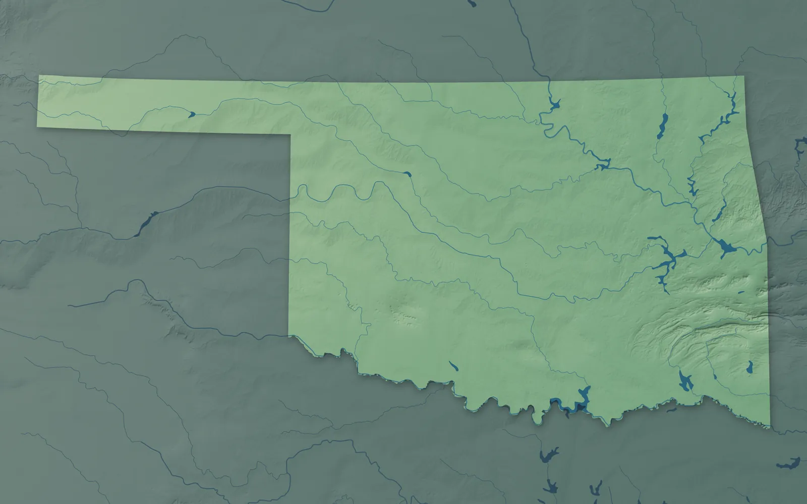
Oklahoma slopes down from the high plains of the Panhandle to the wooded hills and wetlands of the southeast. The Ozark foothills cover the northeast, the Ouachita Mountains the southeast, and the Red River runs along most of the Texas line. Oklahoma became the 46th state in 1907, when Oklahoma Territory and Indian Territory were joined. Its name comes from the Choctaw words okla and humma, meaning red people.
Nearly two of every three Oklahomans live in the Oklahoma City and Tulsa metro areas. Many towns sprang up in a day during the land runs that began in 1889, and others started as railroad stops, oil boomtowns or tribal capitals. Thirty-eight federally recognized tribes have their headquarters in Oklahoma.
- Statehood
- November 16, 1907
- Capital
- Oklahoma City
- Population
- 4,123,2882025 Census estimate
- Highest point
- Black Mesa, 4,975 feet
- Lowest point
- Little River at the Arkansas border, 289 feet
- Size
- 69,899 square miles, the 20th largest state
Oklahoma City and Central Oklahoma
Oklahoma City, Edmond, Norman, Moore and Stillwater are in the Cross Timbers country at the center of the state, a mix of prairie and oak woods. Guthrie and Oklahoma City grew up overnight in the land run of April 22, 1889, and Guthrie was the capital until 1910. Wewoka is the capital of the Seminole Nation, and Shawnee is home to the Citizen Potawatomi Nation. Woody Guthrie, who wrote "This Land Is Your Land," was born in Okemah in 1912.


Tulsa and Green Country
Tulsa, Broken Arrow, Bartlesville, Muskogee and Tahlequah are in the wooded Ozark foothills and lake country of the northeast. Tahlequah has been the Cherokee Nation's capital since 1839 and Okmulgee the Muscogee (Creek) Nation's since 1868, and the Osage Nation is based in Pawhuska. Tulsa boomed after oil strikes in 1901 and 1905 and was long called the Oil Capital of the World. Will Rogers was born near Oologah in 1879, a citizen of the Cherokee Nation.


Kiamichi Country and the Southeast
McAlester, Durant, Poteau, Idabel and Broken Bow sit among the pine forests of the Kiamichi and Ouachita mountains, the lakes and the Red River country. The Choctaw Nation's reservation covers most of this corner, which state maps now call Choctaw Country, and the nation is based in Durant. In Krebs, an old coal camp where many Italian miners settled, Pete's Place has served Italian dinners since 1925. Hugo, called Circus City, USA, has been a winter home for traveling circuses since the early 1940s.


Ardmore, Ada and Chickasaw Country
Ardmore, Ada, Sulphur and Madill sit around the Arbuckle Mountains, old worn-down hills with springs and waterfalls, and Lake Texoma lies on the Red River to the south. The Chickasaw Nation is based in Ada, and its red granite capitol from 1898 still stands in Tishomingo. Sulphur's springs became Platt National Park in 1906, now part of the Chickasaw National Recreation Area. In 1941, Berwyn renamed itself Gene Autry for the singing cowboy, who broadcast his radio show from there.


Lawton and Southwest Oklahoma
Lawton, Duncan, Altus, Elk City and Weatherford sit on the plains of the southwest, where the granite Wichita Mountains rise near Lawton. The Comanche Nation is based in Lawton, the Kiowa Tribe in Carnegie, and the Wichita, Delaware and Apache tribes in Anadarko. In 1907, 15 bison from the Bronx Zoo came to restock the Wichita Mountains, and Comanche leader Quanah Parker was there to welcome them. Texas claimed Greer County, around Mangum, until the Supreme Court ruled against it in 1896.


Enid, Ponca City and the Northwest
Enid, Ponca City, Woodward, Alva and Perry sit among the wheat fields, gypsum mesas and sand dunes of the northwest. About 100,000 people raced for land here on September 16, 1893, when the Cherokee Outlet opened, and Enid was founded that day. Ponca City oilman Ernest Marland finished his mansion, the Palace on the Prairie, in 1928. Near Jet, visitors dig for hourglass-shaped selenite crystals on the Great Salt Plains.


Guymon and the Panhandle
Guymon, Boise City, Hooker, Goodwell and Beaver sit on the high, flat plains of the Panhandle. From 1850 to 1890 this strip belonged to no state or territory, so people called it No Man's Land. Cimarron County, at the western tip, is the only county in the country that borders four states, and Kenton, near Black Mesa, keeps Mountain Time. Beaver hosts the World Cow Chip Throwing Championship every year.


- 12 × 18 inPrint $39.99Framed $89.99
- 18 × 24 inPrint $49.99Framed $129.99
- 24 × 36 inPrint $89.99Framed $199.99

Sizes and Prices
Every map comes in three sizes on archival matte paper. Framed prints come in black or white wood.
How each map is made
It starts with the real place
Streets, buildings, terrain and water form the map, drawn the way Oklahoma looks today.
Then the details
Local research and an old atlas style give each town its character.
Then it's yours
Look around the map, then pick a print to keep or give.