Virginia Town Maps A to Z
All 855 town maps, from Abbs Valley to Yuma. Each one opens its own page with the whole map.
A
- Abbs Valley
- Abingdon
- Accomac
- Achilles
- Addington
- Adwolf
- Afton
- Alberta
- Aldie
- Alexandria
- Allison Gap
- Allisonia
- Alonzaville
- Altavista
- Amelia Court House
- Amherst
- Amonate
- Annandale
- Appalachia
- Apple Mountain Lake
- Appomattox
- Aquia Harbour
- Arcola
- Arlington
- Arlington Forest
- Armel
- Arrington
- Ashburn
- Ashland
- Atkins
- Atlantic
- Atlee
- Auburn
- Augusta Springs
- Austin Ridge
- Austinville
- Avalon
- Axton
B
- Bailey's Crossroads
- Ballston
- Barboursville
- Baskerville
- Bassett
- Bastian
- Basye
- Bayside
- Baywood
- Bealeton
- Beaverdam
- Bedford
- Belfast
- Belle Haven
- Bellwood
- Belmont
- Belmont Estates
- Belspring
- Belview
- Benns Church
- Bensley
- Berkley
- Berryville
- Bethel Manor
- Big Island
- Big Rock
- Big Stone Gap
- Big Stone Gap East
- Blacksburg
- Blackstone
- Blairs
- Bland
- Bloxom
- Blue Ridge
- Blue Ridge Shores
- Bluefield
- Bluemont
- Bobtown
- Boissevain
- Bon Air
- Bonsack
- Boones Mill
- Boston
- Bowling Green
- Bowmans Crossing
- Boyce
- Boydton
- Boykins
- Bracey
- Braddock
- Brambleton
- Branchville
- Brandermill
- Brandy Station
- Breaks
- Brentsville
- Bridgewater
- Brightwood
- Bristol
- Bristow
- Broadlands
- Broadway
- Brodnax
- Brookbury
- Brooke
- Brookneal
- Brosville
- Brucetown
- Buchanan
- Buckhall
- Buckingham Courthouse
- Buckland
- Buena Vista
- Buffalo Gap
- Bull Run, Fairfax County
- Bull Run Mountain Estates
- Bull Run, Prince William County
- Burke
- Burke Centre
- Burkeville
- Burnt Chimney
C
- Callaghan
- Callaway
- Calverton
- Camp Barrett
- Camptown
- Cana
- Cape Charles
- Capron
- Captains Cove
- Carillon
- Carrollton
- Carrsville
- Carysbrook
- Carytown
- Cascades
- Castlewood
- Catlett
- Cats Bridge
- Cave Spring
- Cedar Bluff
- Central Garage
- Centreville
- Chamberlayne
- Chancellor
- Chantilly
- Charles City
- Charlotte Court House
- Charlottesville
- Chase City
- Chase Crossing
- Chatham
- Chatham Heights
- Chatmoss
- Cheriton
- Cherry Hill
- Chesapeake
- Chesapeake Beach
- Chester
- Chester Gap
- Chesterfield
- Chilhowie
- Chincoteague
- Christiansburg
- Church Hill
- Churchville
- Claremont
- Claremont, Arlington
- Clarendon
- Clarksville
- Clary
- Claypool Hill
- Clays Mill
- Clearbrook
- Cleveland
- Clifton
- Clifton Forge
- Cliftondale Park
- Clinchco
- Clinchport
- Clintwood
- Clover
- Cloverdale
- Cluster Springs
- Coeburn
- Collinsville
- Colonial Beach
- Colonial Forge
- Colonial Heights
- Columbia
- Columbia Forest
- Columbia Furnace
- Concord
- Conicville
- Council
- Countryside
- County Center
- Courthouse Square
- Courtland
- Covington
- Craigsville
- Crestview
- Crewe
- Crimora
- Crosspointe
- Crozet
- Culpeper
- Cumberland
D
E
F
- Fair Lakes
- Fair Oaks
- Fairfax
- Fairfax Station
- Fairfield
- Fairland
- Fairlawn
- Fairmount
- Fairview
- Fairview Beach
- Falls Church
- Falls Mills
- Falls Run
- Falmouth
- Fancy Gap
- Farmville
- Ferrum
- Ferry Farm
- Fieldale
- Fincastle
- Fishers Hill
- Fishersville
- Flat Rock
- Flint Hill
- Floris
- Floyd
- Forest
- Forest Hill
- Forestville
- Fort Belvoir
- Fort Blackmore
- Fort Chiswell
- Fort Defiance
- Fort Hunt
- Fort Lee
- Franconia
- Franklin
- Franklin Farm
- Franktown
- Fredericksburg
- Free Union
- Fries
- Front Royal
- Fulks Run
G
- Gainesboro
- Gainesville
- Galax
- Garden City
- Gargatha
- Garrisonville
- Gasburg
- Gate City
- Gayton
- George Mason
- Georgetown
- Glade Spring
- Gladesboro
- Glasgow
- Glen Allen
- Glen Cove
- Glen Lyn
- Glen Wilton
- Glencarlyn
- Glenvar
- Gloucester Courthouse
- Gloucester Point
- Goochland
- Goodview
- Goose Creek Village
- Gordonsville
- Gore
- Goshen
- Grafton
- Grafton Village
- Grandin Court
- Gratton
- Great Falls
- Great Falls Crossing
- Greenbackville
- Greenbriar
- Greenbush
- Greendale
- Greenville
- Greenville, Fauquier County
- Gretna
- Grottoes
- Groveton
- Grundy
- Gwynn
H
- Halifax
- Hallwood
- Hamilton
- Hampden-Sydney
- Hampton
- Hampton Oaks
- Hanover
- Harborton
- Harrisonburg
- Harriston
- Hartwood
- Hayfield
- Haymarket
- Haysi
- Heathsville
- Henry, Charlotte County
- Henry Fork
- Henry, Franklin County
- Herndon
- Hidenwood
- Highland Springs
- Hillsboro
- Hillsville
- Hilltown
- Hilton Village
- Hiltons
- Hiwassee
- Holland
- Hollins
- Hollymead
- Honaker
- Hopewell
- Horntown
- Horse Pasture
- Hot Springs
- Huddleston
- Hudson Crossroads
- Huguenot Farms
- Huntersville
- Huntington
- Hurley
- Hurt
- Hutchison
- Hybla Valley
I
J
K
L
- La Crosse
- Lacey Spring
- Lafayette
- Lake Arrowhead
- Lake Barcroft
- Lake Caroline
- Lake Holiday
- Lake Land'Or
- Lake Monticello
- Lake of the Woods
- Lake Ridge
- Lake Wilderness
- Lakeside
- Lancaster
- Langley
- Lansdowne
- Laurel
- Laurel Hill
- Laurel Park
- Lawrenceville
- Laymantown
- Lebanon
- Lebanon Church
- Lee Hall
- Lee Mont
- Leeland Station
- Leesburg
- Leesylvania
- Lexington
- Liberty
- Lincoln
- Lincolnia
- Linton Hall
- Linville
- Loch Lomond
- Locust Grove
- Locust Mount
- Long Branch
- Lorton
- Loudoun Valley Estates
- Louisa
- Lovettsville
- Lovingston
- Low Moor
- Lowes Island
- Lucketts
- Lunenburg
- Luray
- Lynchburg
- Lyndhurst
- Lyon Village
M
- Madison
- Madison Heights
- Magruder
- Makemie Park
- Mallow
- Manassas
- Manassas Park
- Manchester
- Mantua
- Mappsburg
- Mappsville
- Marion
- Marshall
- Martinsville
- Mason Neck
- Massanetta Springs
- Massanutten
- Massaponax
- Mathews
- Matoaca
- Maurertown
- Max Meadows
- McDowell
- McGaheysville
- McKenney
- McLean
- McMullin
- McNair
- Meadowbrook
- Meadows of Dan
- Meadowview
- Meadville
- Mechanicsburg
- Mechanicsville
- Melfa
- Mendota
- Merrifield
- Merrimac
- Metompkin
- Middlebrook
- Middleburg
- Middletown
- Midland
- Midlothian
- Millboro
- Mineral
- Modest Town
- Moneta
- Montclair
- Monterey
- Montevideo
- Montgomery
- Montrose
- Montross
- Montvale
- Moorefield
- Motley
- Mount Airy
- Mount Clifton
- Mount Crawford
- Mount Hermon
- Mount Jackson
- Mount Olive
- Mount Pleasant
- Mount Sidney
- Mount Vernon
- Mountain Road
- Mountain View, Roanoke
- Mountain View, Rockbridge County
- Mountain View, Stafford County
- Museum District
N
O
P
- Painter
- Palmyra
- Pamplin City
- Pantops
- Paris
- Park Ridge
- Parksley
- Parrott
- Passapatanzy
- Pastoria
- Patrick Springs
- Pattonsville
- Pearisburg
- Pembroke
- Penhook
- Pennington Gap
- Petersburg
- Phenix
- Phoebus
- Pimmit Hills
- Piney Mountain
- Pleasant Valley
- Plum Creek
- Pocahontas
- Poquoson
- Port Republic
- Port Royal
- Portsmouth
- Post Oak
- Potomac Mills
- Pound
- Pounding Mill
- Powellton
- Powhatan
- Prices Fork
- Prince George
- Pulaski
- Pungoteague
- Purcellville
Q
R
S
- Salem
- Saltville
- Saluda
- Sandston
- Sandy Level
- Sanford
- Sanville
- Saumsville
- Savage Town
- Savageville
- Saxis
- Schooner Bay
- Schuyler
- Scotland
- Scottsburg
- Scottsville
- Seaford
- Sealston
- Sedley
- Selma
- Seven Corners
- Seven Mile Ford
- Shawneeland
- Shawsville
- Shenandoah
- Shenandoah Farms
- Shenandoah Retreat
- Shenandoah Shores
- Sherando
- Shipman
- Short Pump
- Sinai
- Singers Glen
- Skyland Estates
- Smithfield
- Snowville
- South Boston
- South Garden
- South Hill
- South Riding
- South Run
- Southampton
- Southampton Meadows
- Southside Chesconessex
- Speedwell
- Sperryville
- Spotsylvania Courthouse
- Springfield
- Springfield, Page County
- Springville
- St. Charles
- St. Paul
- Stafford Lakes Village
- Stanardsville
- Stanley
- Stanleytown
- Staunton
- Stephens City
- Sterling
- Stevens Creek
- Stewartsville
- Stickleyville
- Stone Ridge
- Stonega
- Stony Creek
- Stony Mill
- Stony Point
- Strasburg
- Stuart
- Stuarts Draft
- Sudley
- Suffolk
- Sugar Grove
- Sugarland Run
- Sully Square
- Surry
- Sussex
- Sutherland
- Swords Creek
- Sycolin
T
U
V
W
- Wachapreague
- Wakefield
- Wallace
- Warfield
- Warm Springs
- Warrenton
- Warsaw
- Wasena
- Washington
- Washington Heights
- Watauga
- Waterford
- Watson
- Wattsville
- Waverly
- Waynesboro
- Waynewood
- Weber City
- Weems
- West Falls Church
- West Point
- West Springfield
- Westlake Corner
- Westlake Hills
- Weyers Cave
- Whaleyville
- White Stone
- Whitesville
- Widewater
- Williamsburg
- Willis
- Willis Wharf
- Willow Oaks
- Winchester
- Windsor
- Windsor Farms
- Winona
- Wintergreen
- Winterpock
- Wise
- Wolf Trap
- Woodbine
- Woodbridge
- Woodbrook
- Woodburn
- Woodlake
- Woodland Heights
- Woodlawn
- Woodstock
- Woolwine
- Wyndham
- Wytheville
Y
Don’t see your town? Ask us to draw it.
About Virginia
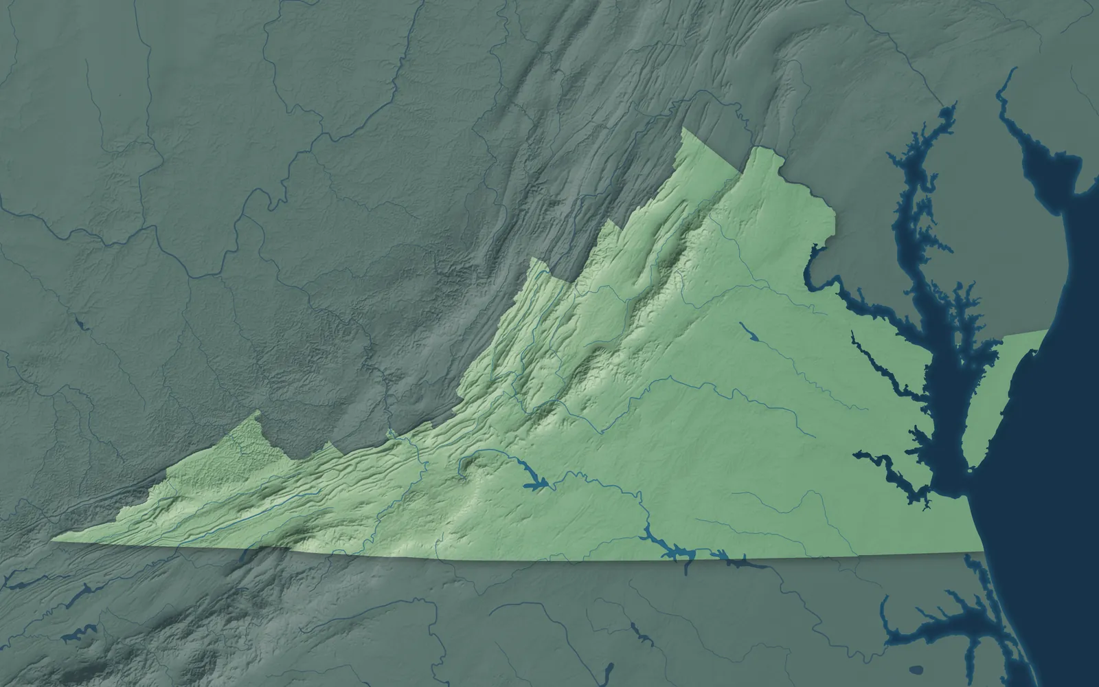
Virginia climbs from the Atlantic beaches and tidal rivers of the Tidewater, across the rolling Piedmont, to the Blue Ridge and the long Appalachian valleys of the west. Its far western tip, at the Cumberland Gap, lies farther west than Detroit. English colonists founded Jamestown in 1607, and in 1788 Virginia became the 10th state, when its convention approved the Constitution by 89 votes to 79.
Most Virginians live in Northern Virginia, around Richmond or in Hampton Roads. Many smaller towns began as tobacco ports on the rivers, mill towns, railroad stops or coal camps, and some county seats are still named for their courthouse, like Amelia Court House. The state recognizes 11 tribes, and each November the Pamunkey and Mattaponi bring the governor a tribute of game, honoring treaties from the 1600s.
- Statehood
- June 25, 1788
- Capital
- Richmond
- Population
- 8,880,1072025 Census estimate
- Highest point
- Mount Rogers, 5,729 feet
- Lowest point
- Atlantic Ocean, sea level
- Size
- 42,775 square miles, the 35th largest state
Northern Virginia and Fredericksburg
Arlington, Alexandria, Fairfax, Reston, Leesburg and Manassas spread west from the Potomac, across from Washington, D.C., and horse country stretches toward the Blue Ridge around Middleburg and Warrenton. Alexandria was laid out in 1749 around a tobacco warehouse, and George Washington's home, Mount Vernon, overlooks the river south of town. Reston takes its name from the initials of Robert E. Simon, who founded it in 1964. Fredericksburg, to the south, became a port on the Rappahannock in 1728.


The Shenandoah Valley
Winchester, Front Royal, Woodstock, Luray, Harrisonburg, Staunton and Lexington sit in the long valley between the Blue Ridge and the Allegheny Mountains. The Shenandoah River flows northeast to the Potomac, so the south end of the Valley is called the upper Valley. Luray Caverns was discovered in 1878, and Woodrow Wilson was born in Staunton in 1856. Farther west, Highland County, called Virginia's Switzerland, holds a maple festival every March.


Richmond, Charlottesville and Lynchburg
Richmond grew up at the falls of the James River, and it's been the capital since 1780. At St. John's Church there in 1775, Patrick Henry gave the speech remembered for "Give me liberty, or give me death!" Petersburg lies just south, and Charlottesville, Culpeper and Lynchburg sit in the rolling Piedmont to the west. Thomas Jefferson built Monticello near Charlottesville and founded the University of Virginia in 1819, and Lynchburg began at John Lynch's ferry across the James.


The Northern Neck and Middle Peninsula
The Northern Neck lies between the Potomac and the Rappahannock, and the Middle Peninsula between the Rappahannock and the York. Colonial Beach, Kilmarnock, Irvington, Tappahannock, Urbanna, West Point and Gloucester are their main towns. George Washington was born at Popes Creek in Westmoreland County in 1732. James Monroe was born in the same county in 1758. When the English arrived, Wahunsenacawh, known as Chief Powhatan, led about 30 tribes from his capital at Werowocomoco, on the York in Gloucester County.


Hampton Roads and Williamsburg
Norfolk, Virginia Beach, Chesapeake, Portsmouth, Suffolk, Hampton and Newport News ring Hampton Roads, one of the world's largest natural harbors, where the James River meets the Chesapeake Bay. Williamsburg was the capital from 1699 to 1780. The British army under Lord Cornwallis surrendered at nearby Yorktown in 1781. Norfolk has the world's largest naval station, and the old Cape Henry Lighthouse, finished in 1792, stands near the spot where the Jamestown colonists first came ashore.


The Eastern Shore
The Eastern Shore is Virginia's end of the Delmarva Peninsula, flat farm and marsh country between the Chesapeake Bay and the Atlantic. Chincoteague, Onancock, Parksley, Exmore and Cape Charles are its towns, and Tangier Island lies out in the bay, reached only by boat or plane. Each July, saltwater cowboys drive the wild ponies of Assateague across the channel to Chincoteague, a tradition that began in 1925. Cape Charles was laid out in 1884 as a railroad and ferry town.


Danville, Martinsville and Southside
Southside is rolling farm and forest country along the North Carolina line, with Danville, Martinsville, South Boston, South Hill, Farmville and Emporia. Martinsville Speedway has held a NASCAR Cup race every year since the series began in 1949, and no other track has. In 1951, 16-year-old Barbara Johns led a student strike at her Farmville high school, and the lawsuit that followed became part of Brown v. Board of Education. Since 2025, her statue and George Washington's have represented Virginia in the U.S. Capitol.


Roanoke and Southwest Virginia
Roanoke, Salem, Blacksburg, Wytheville, Abingdon, Bristol and Big Stone Gap sit among the Blue Ridge, high valleys and coal country that run west to the Cumberland Gap. Roanoke was a small town called Big Lick, named for a salt lick, until the Norfolk and Western Railway put its headquarters there in 1882. In Abingdon, the Barter Theatre opened in 1933, and people could pay for tickets with food from their farms. The Old Fiddler's Convention in Galax began in 1935.


- 12 × 18 inPrint $39.99Framed $89.99
- 18 × 24 inPrint $49.99Framed $129.99
- 24 × 36 inPrint $89.99Framed $199.99

Sizes and Prices
Every map comes in three sizes on archival matte paper. Framed prints come in black or white wood.
How each map is made
It starts with the real place
Streets, buildings, terrain and water form the map, drawn the way Virginia looks today.
Then the details
Local research and an old atlas style give each town its character.
Then it's yours
Look around the map, then pick a print to keep or give.