Maryland Town Maps A to Z
All 881 town maps, from Abell to Zihlman. Each one opens its own page with the whole map.
A
- Abell
- Aberdeen
- Aberdeen Proving Ground
- Abingdon
- Accident
- Accokeek
- Adamstown
- Adelphi
- Algonquin
- Allen
- Allendale
- Andrews AFB
- Annapolis
- Annapolis Neck
- Antietam
- Aquasco
- Arbutus
- Arcadia
- Arden on the Severn
- Arlington
- Armistead Gardens
- Arnold
- Arundel Gardens
- Arundel on the Bay
- Ashburton
- Ashton-Sandy Spring
- Aspen Hill
- Auchentoroly-Parkwood
B
- Baden
- Bagtown
- Bakersville
- Ballenger Creek
- Baltimore
- Baltimore Highlands
- Baltimore Peninsula
- Barclay
- Barclay, Baltimore
- Barnesville
- Barre Circle
- Barrelville
- Barstow
- Barton
- Bartonsville
- Bay View
- Bayview
- Beaver Creek
- Beechfield
- Bel Air
- Bel Air North
- Bel Air South
- Belair-Edison
- Belair-Parkside
- Bellona-Gittings
- Beltsville
- Belvedere
- Benedict
- Bensville
- Berea
- Berlin
- Berwyn Heights
- Bethesda
- Better Waverly
- Betterton
- Beverly Beach
- Beverly Hills
- Biddle Street
- Bier
- Big Pool
- Big Spring
- Bishopville
- Bivalve
- Bladensburg
- Bloomington
- Blythewood
- Bolton Hill
- Boonsboro
- Bowie
- Bowleys Quarters
- Bowling Green
- Bowmans Addition
- Boyd-Booth
- Braddock Heights
- Brandywine
- Breathedsville
- Brentwood
- Brewers Hill
- Bridgeview/Greenlawn
- Broadway East
- Brock Hall
- Broening Manor
- Brookeville
- Brooklyn
- Brooklyn Park
- Brookmont
- Brookview
- Broomes Island
- Brown Station
- Brownsville
- Brunswick
- Bryans Road
- Bryantown
- Buckeystown
- Burkittsville
- Burnt Mills
- Burtonsville
- Butchers Hill
- Butlertown
C
- C&O Canal
- Cabin John
- California
- Callaway
- Callaway-Garrison
- Calvert
- Calvert Beach
- Calverton
- Cambridge
- Cameron Village
- Camp Springs
- Canton
- Canton Industrial Area
- Cape St. Claire
- Capitol Heights
- CARE
- Carlos
- Carney
- Carroll-Camden Industrial Area
- Carroll Manor
- Carroll Park
- Carroll-South Hilton
- Carrollton Ridge
- Catonsville
- Cavetown
- Cearfoss
- Cecil Manor
- Cecilton
- Cedar Heights
- Cedarcroft
- Cedarville
- Cedmont
- Cedonia
- Central Forest Park
- Central Park Heights
- Centreville
- Chance
- Charles North
- Charles Village
- Charlestown
- Charlotte Hall
- Charlton
- Chase
- Cherry Hill
- Cherry Hill, Cecil County
- Chesapeake Beach
- Chesapeake City
- Chesapeake Landing
- Chesapeake Ranch Estates
- Chester
- Chestertown
- Cheswolde
- Cheverly
- Chevy Chase
- Chevy Chase Section Five
- Chevy Chase Section Three
- Chevy Chase View
- Chevy Chase Village
- Chewsville
- Chillum
- Chinquapin Park
- Choptank
- Church Creek
- Church Hill
- Churchville
- Clarksburg
- Clarysville
- Clear Spring
- Clifton Park
- Clinton
- Clopper
- Cloverly
- Cobb Island
- Cockeysville
- Coldspring
- Coldstream Homestead Montebello
- Colesville
- College Park
- Colmar Manor
- Columbia
- Concerned Citizens of Forest Park
- Conowingo
- Coppin Heights/Ash-Co-East
- Coral Hills
- Cordova
- Corriganville
- Cottage City
- Cranberry
- Crellin
- Cresaptown
- Crisfield
- Crofton
- Croom
- Cross Country
- Cross Keys
- Crownsville
- Crumpton
- Cumberland
- Curtis Bay
- Curtis Bay Industrial Area
- Cylburn
D
- Damascus
- Dames Quarter
- Danville
- Dargan
- Darley Park
- Darlington
- Darnestown
- Davidsonville
- Dawson
- Dayton
- Deal Island
- Deale
- Deep Creek Lake
- Deer Park
- Delmar
- Denton
- Derwood
- Detmold
- Dickeyville
- District Heights
- Dolfield
- Dorchester
- Downsville
- Downtown
- Downtown West
- Druid Heights
- Druid Hill Park
- Drum Point
- Dublin
- Dunbar-Broadway
- Dundalk
- Dundalk Marine Terminal
- Dunkirk
- Dynard
E
- Eagle Harbor
- Eakles Mill
- East Arlington
- East Baltimore Midway
- East New Market
- East Riverdale
- Easterwood
- Easton
- Eastwood
- Eckhart Mines
- Eden
- Edesville
- Edgemere
- Edgemont
- Edgewater
- Edgewood
- Edmondson Village
- Edmonston
- Ednor Gardens-Lakeside
- Eldersburg
- Eldorado
- Elk
- Elk Neck
- Elkridge
- Elkton
- Ellerslie
- Ellicott City
- Elliott
- Ellwood Park/Monument
- Emmitsburg
- Ernstville
- Essex
- Evergreen
- Evergreen Lawn
- Evesham Park
F
- Fairfield Area
- Fairland
- Fairlee
- Fairmount
- Fairmount Heights
- Fairplay
- Fairview
- Fairwood
- Fallstaff
- Fallston
- Federal Hill
- Federalsburg
- Fells Point
- Ferndale
- Finzel
- Fishing Creek
- Flintstone
- Flower Hill
- Forest Glen
- Forest Heights
- Forest Hill
- Forest Park
- Forest Park Golf Course
- Forestville
- Fort Howard
- Fort Meade
- Fort Ritchie
- Fort Washington
- Fountainhead-Orchard Hills
- Four By Four
- Four Corners
- Frankford
- Franklin
- Franklin Square
- Franklintown
- Franklintown Road
- Frederick
- Frenchtown-Rumbly
- Friendly
- Friendship
- Friendship Heights Village
- Friendsville
- Frostburg
- Fruitland
- Fulton
- Funkstown
G
- Gaithersburg
- Galena
- Galestown
- Galesville
- Gambrills
- Gapland
- Garrett Park
- Garretts Mill
- Garrison
- Garwyn Oaks
- Gay Street
- Georgetown
- Germantown
- Gilmore
- Girdletree
- Glassmanor
- Glen
- Glen Burnie
- Glen Echo
- Glen Oaks
- Glenarden
- Glenelg
- Glenmont
- Glenn Dale
- Glenwood
- Glyndon
- Golden Beach
- Goldsboro
- Gorman
- Goshen
- Graceham
- Graceland Park
- Grahamtown
- Grantsville
- Grasonville
- Great Mills
- Greektown
- Green Valley
- Greenbelt
- Greenmount Cemetery
- Greenmount West
- Greensboro
- Greensburg
- Greenspring
- Grove Park
- Guilford
- Gunpowder
- Gwynns Falls
- Gwynns Falls/Leakin Park
H
- Hagerstown
- Halfway
- Hamilton
- Hamilton Hills
- Hampden
- Hampstead
- Hampton
- Hancock
- Hanlon-Longwood
- Hanover Hills
- Harbor East
- Harbor Point
- Harlem Park
- Harwood
- Havre de Grace
- Hawkins Point
- Hebron
- Henderson
- Herald Harbor
- Hereford
- Heritage Crossing
- Hernwood
- Herring Run Park
- Hickory
- Highfield-Cascade
- Highland
- Highland Beach
- Highlandtown
- Hillandale
- Hillcrest Heights
- Hillen
- Hillsboro
- Hoes Heights
- Holabird Industrial Park
- Hollins Market
- Hollywood
- Homeland
- Honeygo
- Hopkins Bayview
- Howard Park
- Hughesville
- Hunting Ridge
- Huntingtown
- Hurlock
- Hutton
- Hyattsville
I
J
K
L
- La Plata
- La Vale
- Lake Arbor
- Lake Evesham
- Lake Shore
- Lake Walker
- Lakeland
- Landover
- Landover Hills
- Langley Park
- Langston Hughes
- Lanham
- Lansdowne
- Largo
- Lauraville
- Laurel
- Layhill
- Laytonsville
- Leeds
- Leisure World
- Leitersburg
- Leonardtown
- Levindale
- Lewistown
- Lexington Park
- Liberty Reservoir
- Liberty Square
- Libertytown
- Linganore
- Linthicum
- Lisbon
- Little Italy
- Little Orleans
- Little Seneca Lake
- Loch Lynn Heights
- Loch Raven
- Loch Raven Reservoir
- Lochearn
- Locust Point
- Locust Point Industrial Area
- Lonaconing
- Long Beach
- Lothian
- Lower Herring Run Park
- Loyola/Notre Dame
- Lucille Park
- Luke
- Lusby
- Lutherville
M
- Madison
- Madison-Eastend
- Madison Park
- Malcolm
- Manchester
- Manor
- Mapleville
- Mardela Springs
- Marlboro Meadows
- Marlboro Village
- Marlow Heights
- Marlton
- Martin's Additions
- Marydel
- Maryland City
- Maryland Park
- Maugansville
- Mayfield
- Mayo
- Mays Chapel
- McCoole
- McElderry Park
- Mechanicsville
- Medfield
- Medford
- Melwood
- Mercersville
- Mid-Govans
- Mid-Town Belvedere
- Middle Branch/Reedbird Parks
- Middle East
- Middle River
- Middleburg
- Middletown
- Midland
- Midlothian
- Midtown-Edmondson
- Milford Mill
- Millersville
- Millhill
- Millington
- Milton-Montford
- Mitchellville
- Mondawmin
- Monrovia
- Montebello
- Montgomery Village
- Moravia-Walther
- Morgan Park
- Morgan State University
- Morningside
- Morrell Park
- Moscow
- Mosher
- Mount Aetna
- Mount Airy
- Mount Briar
- Mount Clare
- Mount Harmony
- Mount Holly
- Mount Lena
- Mount Rainier
- Mount Savage
- Mount Vernon
- Mount Washington
- Mount Winans
- Mountain Lake Park
- Mt Pleasant Park
- Mutual
- Myersville
N
- Nanjemoy
- Nanticoke
- Nanticoke Acres
- National
- National Harbor
- Naval Academy
- New Carrollton
- New Market
- New Midway
- New Northwood
- New Windsor
- Newark
- Nikep
- Norrisville
- North Beach
- North Bethesda
- North Brentwood
- North Chevy Chase
- North East
- North Harford Road
- North Kensington
- North Laurel
- North Potomac
- North Roland Park/Poplar Hill
- Northwest Community Action
O
P
- Panway/Braddish Avenue
- Paramount-Long Meadow
- Park Circle
- Park Hall
- Parklane
- Parkside
- Parkville
- Parkway
- Parole
- Parsonsburg
- Pasadena
- Patterson Park
- Patterson Park Neighborhood
- Patterson Place
- Pecktonville
- Pen Lucy
- Penn-Fallsway
- Penn North
- Penrose/Fayette Street Outreach
- Peppermill Village
- Perkins
- Perring Loch
- Perry Hall
- Perryman
- Perryville
- Pikesville
- Pimlico Good Neighbors
- Pinesburg
- Piney Point
- Pittsville
- Pleasant Grove
- Pleasant Hills
- Pleasant Valley
- Pleasant View Gardens
- Plum Point
- Pocomoke City
- Point of Rocks
- Pomfret
- Pondsville
- Poolesville
- Poppleton
- Port Deposit
- Port Tobacco Village
- Potomac
- Potomac Heights
- Potomac Park
- Powellville
- Preston
- Prettyboy
- Prettyboy Reservoir
- Prince Frederick
- Princess Anne
- Pulaski Industrial Area
- Purnell
- Pylesville
Q
R
- Radnor-Winston
- Ramblewood
- Randallstown
- Rawlings
- Redland
- Reid
- Reisterstown
- Reisterstown Station
- Remington
- Reservoir Hill
- Richnor Springs
- Ridge
- Ridgely
- Ridgely's Delight
- Ringgold
- Rising Sun
- Riva
- Riverdale Park
- Riverside
- Riviera Beach
- Robinwood
- Rock Hall
- Rock Point
- Rockville
- Rocky Gorge Reservoir
- Rognel Heights
- Rohrersville
- Roland Park
- Romancoke
- Rosaryville
- Rosebank
- Rosedale
- Rosemont
- Rosemont, Baltimore
- Rosemont East
- Rosemont Homeowners/Tenants
- Rosemont, Montgomery County
- Rossville
S
- Sabillasville
- Sabina-Mattfeldt
- Saint Agnes
- Saint Helena
- Saint Josephs
- Saint Paul
- Salisbury
- San Mar
- Sandtown-Winchester
- Sandy Hook
- Savage
- Scaggsville
- Seabrook
- Seat Pleasant
- Secretary
- Seton Business Park
- Seton Hill
- Severn
- Severna Park
- Shady Side
- Shaft
- Sharp-Leadenhall
- Sharpsburg
- Sharptown
- Shiloh
- Shipley Hill
- Showell
- Silver Hill
- Silver Spring
- Smith Island
- Smithsburg
- Snow Hill
- Solomons
- Somerset
- South Baltimore
- South Clifton Park
- South Kensington
- South Laurel
- South River
- Sparks
- Spencerville
- Spring Gap
- Spring Garden Industrial Area
- Spring Ridge
- Spring Ridge, St. Mary's County
- Springdale
- St. George Island
- St. James
- St. Leonard
- St. Michaels
- Stadium/Entertainment Area
- Stevensville
- Still Pond
- Stockton
- Stonewood-Pentwood-Winston
- Sudlersville
- Suitland
- Summerfield
- Sunderland
- Swan Creek
- Swanton
- Sykesville
T
- Takoma Park
- Tall Timbers
- Taneytown
- Taylor Heights
- Taylors Island
- Temple Hills
- Templeville
- Ten Hills
- Ten Mile Creek
- The Orchards
- Thomson Estates
- Thurmont
- Tilghman Island
- Tilghmanton
- Timber Grove
- Timonium
- Tolchester
- Towanda-Grantley
- Towson
- Trappe
- Travilah
- Trego-Rohrersville Station
- Tremont
- Triadelphia Reservoir
- Tuscany-Canterbury
- Tyaskin
U
V
W
- Wakefield
- Walbrook
- Waldorf
- Walker Mill
- Walkersville
- Waltherson
- Washington Grove
- Washington Hill
- Washington Village/Pigtown
- Waterview
- Watkins Mill
- Waverly
- West Arlington
- West Denton
- West Forest Park
- West Friendship
- West Hills
- West Laurel
- West Ocean City
- West Pocomoke
- Westernport
- Westfield
- Westgate
- Westminster
- Westphalia
- Westport
- Whaleyville
- Wheaton
- White Marsh
- White Oak
- Whitehaven
- Wildewood
- Wilhelm Park
- Willards
- Williamsport
- Williston
- Wilson-Conococheague
- Wilson Park
- Winchester
- Windsor Hills
- Winfield
- Winston-Govans
- Wolfsville
- Woodberry
- Woodbourne Heights
- Woodbourne-McCabe
- Woodland
- Woodlawn, Baltimore County
- Woodlawn, Prince George's County
- Woodmere
- Woodmore
- Woodsboro
- Worton
- Wyman Park
- Wyndhurst
Y
Z
Don’t see your town? Ask us to draw it.
About Maryland
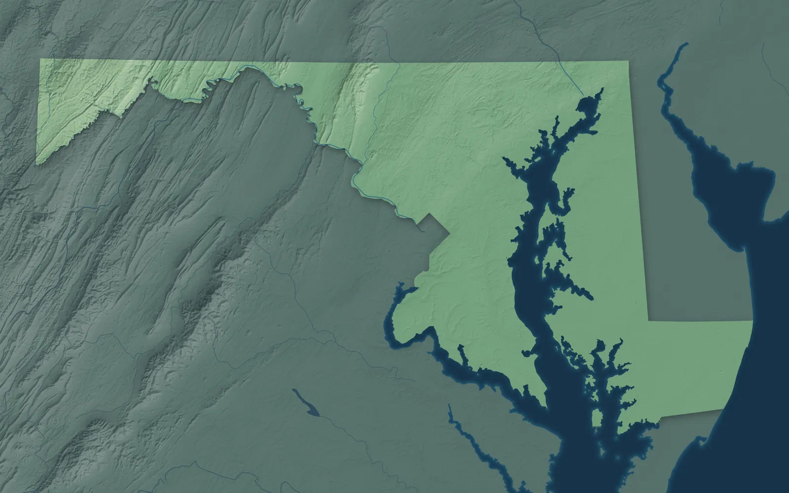
Maryland wraps around the Chesapeake Bay, from Ocean City on the Atlantic to the mountains of Garrett County. Near Hancock it's only about 1.8 miles wide, between the Pennsylvania line and the Potomac River. Maryland became the seventh state in 1788, and in 1791 it gave up the land where Washington, D.C., stands today.
Most Marylanders live between Baltimore and Washington, D.C. Towns here began as tobacco ports on the bay's rivers, mill towns on fast streams, and canal and railroad towns in the mountains. On the Eastern Shore, many started as fishing and farm villages. In 1649, the colony's assembly passed the Toleration Act, one of the first laws in America to protect freedom of worship.
- Statehood
- April 28, 1788
- Capital
- Annapolis
- Population
- 6,265,3472025 Census estimate
- Highest point
- Hoye-Crest, 3,370 feet
- Lowest point
- Atlantic Ocean, sea level
- Size
- 12,406 square miles, the 42nd largest state
Baltimore and Its Neighborhoods
Baltimore grew up around its harbor on the Patapsco River. Its neighborhoods, from Fells Point and Federal Hill to Canton and Hampden, are full of brick rowhouses, many with white marble steps. In 1814, the defense of Fort McHenry inspired Francis Scott Key to write the words of the national anthem. The Baltimore and Ohio, one of the country's first railroads, began here on July 4, 1828. The Washington Monument in the Mount Vernon neighborhood, begun in 1815, was the first major monument to George Washington.


Annapolis and Central Maryland
Annapolis, the state capital, sits on the Severn River. Towson, Catonsville, Columbia, Ellicott City, Bel Air and Westminster spread through the rolling country around Baltimore. George Washington resigned as head of the Continental Army in the Annapolis State House in 1783. It's the oldest state capitol in continuous use by its legislature. Ellicott City began as a flour mill town in 1772, and its old B&O depot is the oldest surviving railroad station in the country. Columbia was planned from scratch and opened in 1967.


Frederick and the Capital Region
Bethesda, Silver Spring, Rockville, Gaithersburg, Bowie and College Park sit just outside Washington, D.C. Frederick lies farther northwest, among farms and the Catoctin Mountains. College Park Airport, where Wilbur Wright taught Army officers to fly in 1909, is the world's oldest airport still in use. Clara Barton ran the American Red Cross from her house in Glen Echo from 1897 to 1904. Frederick's church steeples are the "clustered spires" of John Greenleaf Whittier's 1863 poem "Barbara Frietchie."


Western Maryland and the C&O Canal
Western Maryland is mountain country, from Hagerstown in its wide valley to Hancock, Cumberland, Frostburg and Oakland, near Deep Creek Lake. Jonathan Hager laid out Hagerstown in 1762. Work on the National Road, the first highway paid for by the federal government, began at Cumberland in 1811. The C&O Canal follows the Potomac for 184.5 miles and ends at Cumberland. Mule teams towed boats loaded with coal down the canal until 1924, and today it's a national historical park.


Southern Maryland
Southern Maryland is the low, wooded land between the Potomac and the Chesapeake, with Waldorf, La Plata, Leonardtown, Lexington Park, Prince Frederick and Solomons. Maryland began here in 1634, when colonists from the Ark and the Dove landed at St. Clement's Island. They built St. Mary's City, the first capital, on land bought from the Yaocomico people. Tobacco was the main crop for over 300 years, and old tobacco barns still stand. Calvert Cliffs hold fossil shark teeth 10 to 20 million years old.


The Eastern Shore
East of the Chesapeake Bay, the Eastern Shore is flat farm and marsh country cut by rivers. Its towns include Elkton, Chestertown, Easton, Cambridge, Salisbury and Berlin. Harriet Tubman was born in Dorchester County in 1822, escaped slavery in 1849 and returned again and again to lead others to freedom. Ocean City, on the Atlantic, began with the Atlantic Hotel, opened on July 4, 1875. Smith Island, reached only by boat, gave Maryland its state dessert, a cake of eight or more thin layers.


- 12 × 18 inPrint $39.99Framed $89.99
- 18 × 24 inPrint $49.99Framed $129.99
- 24 × 36 inPrint $89.99Framed $199.99

Sizes and Prices
Every map comes in three sizes on archival matte paper. Framed prints come in black or white wood.
How each map is made
It starts with the real place
Streets, buildings, terrain and water form the map, drawn the way Maryland looks today.
Then the details
Local research and an old atlas style give each town its character.
Then it's yours
Look around the map, then pick a print to keep or give.