North Carolina Town Maps A to Z
All 952 town maps, from Aberdeen to Zebulon. Each one opens its own page with the whole map.
A
B
- Badin
- Badin Lake
- Bailey
- Bakersville
- Bald Head Island
- Balfour
- Banner Elk
- Banoak
- Barbecue
- Barker Heights
- Barker Ten Mile
- Barnardsville
- Bath
- Baton
- Bayboro
- Bayshore
- Bayview
- Bear Grass
- Beaufort
- Beech Mountain
- Belews Lake
- Belhaven
- Bell Arthur
- Belmont
- Belmont, Halifax County
- Belville
- Belvoir
- Belwood
- Bennett
- Benson
- Bent Creek
- Bermuda Run
- Berryhill
- Bessemer City
- Bethania
- Bethany
- Bethel
- Bethel, Haywood County
- Bethel Hill
- Bethel, Watauga County
- Bethlehem
- Beulaville
- Biddleville
- Biltmore Forest
- Biscoe
- Black Creek
- Black Mountain
- Blackburn
- Bladenboro
- Blowing Rock
- Blue Clay Farms
- Boardman
- Bogue
- Boiling Spring Lakes
- Boiling Springs
- Bolivia
- Bolton
- Bonlee
- Bonnetsville
- Boomer
- Boone
- Boonville
- Bostic
- Bowdens
- Bowmore
- Brandywine Bay
- Brevard
- Briar Chapel
- Brices Creek
- Bridgeton
- Broad Creek
- Broadway
- Brogden
- Brookford
- Brunswick
- Bryson City
- Buckland
- Buies Creek
- Bunn
- Bunnlevel
- Burgaw
- Burlington
- Burnsville
- Butner
- Butters
- Buxton
C
- Cajah's Mountain
- Calabash
- Calypso
- Camden
- Cameron
- Candler
- Candor
- Cane
- Cane River
- Canton
- Cape Carteret
- Cape Colony
- Caroleen
- Carolina Beach
- Carolina Meadows
- Carolina Shores
- Carpenter
- Carrboro
- Carthage
- Cary
- Casar
- Cashiers
- Castalia
- Castle Hayne
- Caswell Beach
- Catawba
- Cedar Point
- Cedar Rock
- Centerville
- Central
- Cerro Gordo
- Chadbourn
- Chapel Hill
- Charlotte
- Cherokee
- Cherry Branch
- Cherryville
- Chestnut Grove
- Chicod
- Chimney Rock Village
- China Grove
- Chinquapin
- Chocowinity
- Chowan
- Chowan Beach
- Churchland
- Claremont
- Clarkton
- Clayton
- Clear Creek
- Clement
- Clemmons
- Cleveland
- Cliffside
- Clingman
- Clinton
- Clover Garden
- Clyde
- Coats
- Cofield
- Coinjock
- Colerain
- Coleridge
- Colfax
- Collettsville
- Columbia
- Columbus
- Comfort
- Como
- Concord
- Conetoe
- Connelly Springs
- Conover
- Conway
- Cooleemee
- Copeland
- Cordova
- Cornatzer
- Cornelius
- Courtney
- Cove City
- Cove Creek
- Cramerton
- Cranberry
- Creedmoor
- Creswell
- Cricket
- Crossnore
- Crouse
- Cullowhee
- Cypress Landing
D
E
F
- Fair Bluff
- Fairfield
- Fairfield Harbour
- Fairmont
- Fairplains
- Fairview
- Faison
- Faith
- Falcon
- Falkland
- Fallston
- Farmer
- Farmington
- Farmville
- Fayetteville
- Fearrington Village
- Ferguson
- Five Points
- Flat Rock
- Fletcher
- Fontana Dam
- Fontana Lake
- Forbush
- Forest City
- Forest Hills
- Forest Oaks
- Foscoe
- Fountain
- Four Oaks
- Foxfire
- Franklin
- Franklin, Surry County
- Franklinton
- Franklinville
- Fremont
- Frisco
- Fruitland
- Fuquay-Varina
G
- Gamewell
- Garland
- Garner
- Garysburg
- Gaston
- Gastonia
- Gatesville
- Germanton
- Gerton
- Gibson
- Gibsonville
- Glen Alpine
- Glen Raven
- Glenville
- Glenwood
- Gloucester
- Godwin
- Gold Hill
- Goldsboro
- Goldston
- Gorman
- Governors Club
- Governors Village
- Graham
- Graingers
- Grandfather Village
- Grandy
- Granite Falls
- Granite Quarry
- Grantham
- Grantsboro
- Grays Chapel
- Great Smoky Mountains National Park
- Green Level
- Greenevers
- Greensboro
- Greenville
- Grifton
- Grimesland
- Grover
- Gulf
H
- Half Moon
- Halifax
- Hallsboro
- Hamilton
- Hamlet
- Hampstead
- Happy Valley
- Harkers Island
- Harmony
- Harnett
- Harrells
- Harrellsville
- Harris
- Harrisburg
- Hassell
- Hatteras
- Havelock
- Haw River
- Hawfields
- Hayesville
- Hays
- Hemby Bridge
- Henderson
- Hendersonville
- Henrietta
- Hertford
- Hickory
- Hiddenite
- High Point
- High Shoals
- Highlands
- Hightsville
- Hildebran
- Hillsborough
- Hiwassee
- Hobbton
- Hobgood
- Hobucken
- Hoffman
- Holden Beach
- Hollister
- Holly Ridge
- Holly Springs
- Hominy
- Hookerton
- Hoopers Creek
- Hope Mills
- Horse Shoe
- Hot Springs
- Hudson
- Huntersville
- Hyco Lake
I
J
K
L
- La Grange
- Lake Gaston
- Lake Glenville
- Lake James
- Lake Junaluska
- Lake Lure
- Lake Mattamuskeet
- Lake Norman
- Lake Norman of Catawba
- Lake Norman of Iredell
- Lake Park
- Lake Phelps
- Lake Royale
- Lake Santeetlah
- Lake Tillery
- Lake Waccamaw
- Lake Wylie
- Lakeview
- Landis
- Lansing
- Lasker
- Lattimore
- Laurel
- Laurel Hill
- Laurel Park
- Laurinburg
- Lawndale
- Lawsonville
- Leggett
- Leicester
- Leland
- Lenoir
- Level Cross
- Lewiston Woodville
- Lewisville
- Lexington
- Liberty
- Light Oak
- Lilesville
- Lillington
- Lincolnton
- Linden
- Linville
- Littleton
- Locust
- Long Branch
- Long Creek
- Long View
- Louisburg
- Love Valley
- Lowell
- Lowesville
- Lowgap
- Lucama
- Lumber Bridge
- Lumberton
M
- Mabel
- Macclesfield
- Macon
- Madison
- Maggie Valley
- Magnolia
- Maiden
- Malpass Corner
- Mamers
- Manns Harbor
- Manteo
- Mar-Mac
- Marble
- Marietta
- Marion
- Mars Hill
- Marshall
- Marshallberg
- Marshville
- Martins Creek
- Marvin
- Matthews
- Maury
- Maxton
- Mayodan
- Maysville
- McAdenville
- McDonald
- McFarlan
- McLeansville
- Mebane
- Mesic
- Micaville
- Micro
- Middleburg
- Middlesex
- Midland
- Midway
- Midway, Sampson County
- Millers Creek
- Millingport
- Mills River
- Milton
- Milwaukee
- Mineral Springs
- Minnesott Beach
- Mint Hill
- Misenheimer
- Mocksville
- Momeyer
- Moncure
- Monroe
- Monroeton
- Monticello
- Montreat
- Mooresboro
- Mooresville
- Moravian Falls
- Morehead City
- Morganton
- Morrisville
- Morven
- Moss Hill
- Mount Airy
- Mount Gilead
- Mount Holly
- Mount Olive
- Mount Olive, Stokes County
- Mount Pleasant
- Mount Pleasant, Wilkes County
- Mount Vernon
- Mountain Home
- Mountain Island
- Mountain Island Lake
- Mountain Park
- Mountain View
- Moyock
- Mulberry
- Murfreesboro
- Murphy
- Murraysville
- Myrtle Grove
N
- Nags Head
- Nakina
- Nantahala
- Nantahala Lake
- Nashville
- Navassa
- Nebo
- Neuse Forest
- New Bern
- New Hope
- New Hope, Orange County
- New Hope, Wilson County
- New London
- New Market
- New Salem
- Newland
- Newport
- Newton
- Newton Grove
- Norlina
- Norman
- North Belmont
- North Cove
- North Topsail Beach
- North Wilkesboro
- Northchase
- Northlakes
- Northwest
- Norwood
O
P
- Pactolus
- Pantego
- Parkton
- Parmele
- Patterson Springs
- Peachland
- Peachtree
- Peletier
- Pembroke
- Penderlea
- Pikeville
- Pilot Mountain
- Pine Hall
- Pine Knoll Shores
- Pine Level
- Pinebluff
- Pinehurst
- Pinetops
- Pinetown
- Pineville
- Piney Creek
- Piney Green
- Pink Hill
- Pinnacle
- Pisgah Forest
- Pittsboro
- Plain View
- Pleasant Garden
- Pleasant Gardens
- Pleasant Grove
- Pleasant Hill
- Plymouth
- Polkton
- Polkville
- Pollocksville
- Poplar Springs
- Porters Neck
- Potters Hill
- Powellsville
- Princeton
- Princeville
- Proctorville
- Prospect
- Pumpkin Center
- Pumpkin Center, Lincoln County
R
- Raeford
- Raemon
- Raleigh
- Ramseur
- Randleman
- Ranlo
- Raynham
- Red Cross
- Red Oak
- Red Springs
- Reid Park
- Reidsville
- Rennert
- Rex
- Rhodhiss
- Rich Square
- Richfield
- Richlands
- Riegelwood
- River Bend
- River Road
- Roanoke Rapids
- Roaring River
- Robbins
- Robbinsville
- Roberdel
- Robersonville
- Rock Rest
- Rock Ridge
- Rockfish
- Rockingham
- Rockwell
- Rocky Mount
- Rocky Point
- Rocky River
- Rodanthe
- Rolesville
- Ronda
- Roper
- Rose Hill
- Roseboro
- Rosewood
- Rosman
- Rougemont
- Rowland
- Roxboro
- Roxobel
- Royal
- Royal Pines
- Ruffin
- Rugby
- Rural Hall
- Ruth
- Rutherford College
- Rutherfordton
S
- Salem
- Salemburg
- Salisbury
- Saluda
- Salvo
- Sandy Creek
- Sandy Grove
- Sandy Ridge
- Sandyfield
- Sanford
- Saratoga
- Savannah
- Sawmills
- Saxapahaw
- Scotch Meadows
- Scotland Neck
- Scotts
- Sea Breeze
- Seaboard
- Seaforth
- Seagrove
- Sedalia
- Sedgefield
- Selma
- Seven Devils
- Seven Lakes
- Seven Springs
- Severn
- Shallotte
- Shannon
- Sharon
- Sharpsburg
- Shawboro
- Shawtown
- Shelby
- Shoals
- Siler City
- Silk Hope
- Silver City
- Silver Lake
- Silver Valley
- Silverdale
- Simpson
- Sims
- Skippers Corner
- Smithfield
- Smithtown
- Smyrna
- Sneads Ferry
- Snow Hill
- South Henderson
- South Mills
- South Rosemary
- South Weldon
- Southern Pines
- Southern Shores
- Southmont
- Southport
- Southwest
- Southwood
- Sparta
- Speed
- Spencer
- Spencer Mountain
- Spindale
- Spivey's Corner
- Spout Springs
- Spring Hill
- Spring Hope
- Spring Lake
- Springdale
- Spruce Pine
- St. Helena
- St. James
- St. Pauls
- St. Stephens
- Staley
- Stallings
- Stanfield
- Stanley
- Stantonsburg
- Star
- Statesville
- Stedman
- Stem
- Stokes
- Stokesdale
- Stoneville
- Stonewall
- Stoney Point
- Stony Point
- Stovall
- Sugar Mountain
- Summerfield
- Sunbury
- Sunny View
- Sunset Beach
- Sunshine
- Supply
- Surf City
- Swan Quarter
- Swannanoa
- Swansboro
- Swepsonville
- Sylva
T
U
V
W
- Waco
- Wade
- Wadesboro
- Wagram
- Wake Forest
- Wakulla
- Walkertown
- Wallace
- Wallburg
- Walnut Cove
- Walnut Creek
- Walstonburg
- Wanchese
- Warrenton
- Warsaw
- Washington
- Washington Park
- Watha
- Waves
- Waxhaw
- Waynesville
- Weaverville
- Webster
- Weddington
- Weeksville
- Welcome
- Weldon
- Wendell
- Wentworth
- Wesley Chapel
- West Canton
- West Edgecombe
- West End
- West Jefferson
- West Marion
- West Rockingham
- Westfield
- Westport
- Whispering Pines
- Whitakers
- White Lake
- White Oak
- White Plains
- Whiteville
- Whitsett
- Whittier
- Wilkesboro
- Williams
- Williamsburg
- Williamston
- Willow Springs
- Wilmington
- Wilson
- Wilson's Mills
- Wilton
- Windsor
- Winfall
- Wingate
- Winston-Salem
- Winterville
- Winton
- Woodfin
- Woodington
- Woodland
- Woodlawn
- Wrightsboro
- Wrightsville Beach
Y
Z
Don’t see your town? Ask us to draw it.
About North Carolina
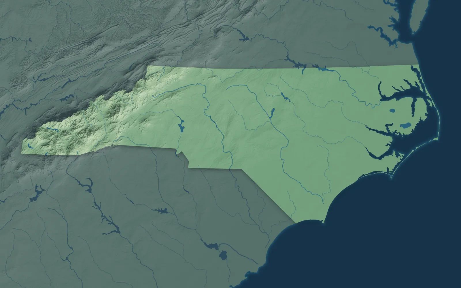
North Carolina stretches about 500 miles from the Great Smoky Mountains to the Outer Banks, across the rolling Piedmont and the flat Coastal Plain. It wouldn't ratify the Constitution until a bill of rights was promised, and it became the 12th state on November 21, 1789.
Most North Carolinians live around Charlotte, the Triangle and the Triad, the three big metro areas of the Piedmont. Many towns began as mill villages, tobacco markets, railroad stops or river ports. In 2025, the Lumbee Tribe of southeastern North Carolina won full federal recognition, 137 years after it first asked Congress.
- Statehood
- November 21, 1789
- Capital
- Raleigh
- Population
- 11,197,9682025 Census estimate
- Highest point
- Mount Mitchell, 6,684 feet
- Lowest point
- Atlantic Ocean, sea level
- Size
- 53,819 square miles, the 28th largest state
Asheville and the Mountains
Asheville, Boone, Hendersonville and Waynesville sit in the Blue Ridge and Great Smoky Mountains, and Hickory, Morganton and Lenoir lie in the foothills below. George Vanderbilt finished Biltmore, his 250-room house in Asheville, in 1895, and it's still the largest privately owned home in the country. The Eastern Band of Cherokee Indians has its home on the Qualla Boundary, around the town of Cherokee. Boone is named for Daniel Boone, who camped there on several trips.


The Charlotte Area
Charlotte, the Queen City, is named for Queen Charlotte, the wife of King George III. Concord, Gastonia, Mooresville and Salisbury fill the rolling Piedmont around it, with Lake Norman to the north. In 1799, 12-year-old Conrad Reed found a 17-pound rock in Cabarrus County, and it served as the family doorstop until a jeweler saw it was gold. It was the first documented gold find in the country and set off its first gold rush.


Greensboro and the Triad
Greensboro, Winston-Salem, High Point, Burlington and Asheboro sit in the rolling hills of the Piedmont Triad. Moravians began building Salem in 1766, and many of its original buildings still stand in Old Salem. High Point is named for the highest spot on the old North Carolina Railroad, and its furniture market meets there every April and October. Mount Airy is Andy Griffith's hometown and is thought to be the model for Mayberry.


Raleigh and the Triangle
Raleigh, Cary, Durham and Chapel Hill are the main towns of the Triangle, home to three big research universities: NC State, Duke and UNC. Raleigh was laid out in 1792 as the new capital and named for Sir Walter Raleigh. UNC began taking students in 1795, which makes it one of the oldest public universities in the country. Durham grew up around a railroad depot built in 1849, and its tobacco factories made it a city.


Fayetteville and the Sandhills
Fayetteville, Sanford, Pinehurst, Southern Pines and Laurinburg sit in the Sandhills, rolling hills of old wind-blown sand covered in longleaf pine. Scottish Highlanders began settling along the upper Cape Fear River in 1739. Fayetteville was the first city in the country named for the Marquis de Lafayette, who visited in 1825. James Walker Tufts founded Pinehurst in 1895 as a health resort, and its golf courses have hosted the men's U.S. Open four times.


Greenville and the Coastal Plain
Greenville, Rocky Mount, Wilson, Goldsboro, Kinston and Lumberton sit in the flat farm country of the Coastal Plain, where sweet potatoes and tobacco grow. At Halifax on April 12, 1776, North Carolina made the first official call by a colony for independence, and that date is on the state flag. Bath, chartered in 1705, was the colony's first town. Princeville, chartered in 1885, was the first independently governed Black town in the country.


Wilmington and the Southern Coast
Wilmington, Jacksonville, New Bern and Southport sit along the beaches, sounds and rivers of the southern coast, with Morehead City and Emerald Isle on the Crystal Coast. Swiss and German settlers founded New Bern in 1710 and named it for Bern, Switzerland. A New Bern pharmacist first made the drink that became Pepsi in 1893. Old Baldy, the lighthouse built in 1817 on Bald Head Island, is the oldest one still standing in North Carolina.


The Outer Banks and Albemarle
Kitty Hawk, Nags Head and Ocracoke sit on the Outer Banks, a chain of thin barrier islands. Manteo, Elizabeth City and Edenton are on the sounds and rivers behind them. On December 17, 1903, the Wright brothers made the first successful powered airplane flights at Kill Devil Hills, near Kitty Hawk. In 1774, 51 women in Edenton signed a pledge to give up British tea and cloth, one of the first political protests by women in the colonies.


- 12 × 18 inPrint $39.99Framed $89.99
- 18 × 24 inPrint $49.99Framed $129.99
- 24 × 36 inPrint $89.99Framed $199.99

Sizes and Prices
Every map comes in three sizes on archival matte paper. Framed prints come in black or white wood.
How each map is made
It starts with the real place
Streets, buildings, terrain and water form the map, drawn the way North Carolina looks today.
Then the details
Local research and an old atlas style give each town its character.
Then it's yours
Look around the map, then pick a print to keep or give.